SPECIAL ANNOUNCEMENT |
 |
Come join forecasters from the UAC along with the talented athletes from Boondockers for our second annual Essential Avy and Riding Skills Workshop.There are a a few open slots left. Click here for more details. |
|
|
BOTTOM LINE
Danger by aspect and elevation on slopes approaching 35° or steeper.
(click HERE for tomorrow's danger rating)
|
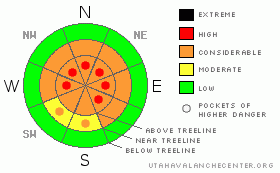
Danger Rose Tutorial
|
In steep, rocky, mid and upper elevation terrain the stability pattern is complicated and the avalanche danger is CONSIDERABLE (Level 3) on slopes that face northwest through southeast, particularly those with a shallow snowpack. Dangerous human triggered slides which break into weak snow near the ground are probable in this type of terrain. By day’s end I expect the avalanche danger to rise to HIGH (Level 4) with both natural and human triggered slides becoming likely.
Low elevation terrain and most mid elevation sun exposed slopes have a LOW avalanche danger.
|
|
|
CURRENT CONDITIONS |

|
Clouds are streaming into the region and finally, there’s a storm on our doorstep that isn’t going to take a detour and dive south. Southwesterly winds picked up around 10:00 last night and have been blowing 25-35 mph along the ridges with a few gusts near 45 mph near the highest peaks. Currently, temperatures are in the low 20’s at 8,000’ and upper teens at 10,000’. Riding and turning conditions are a mixed bag at best and there’s lots of wind damage up high, though you can still find soft settled powder in sheltered, shady terrain.
|
|
|
RECENT ACTIVITY |

|
It’s been rather active on the eastern front the past couple o’ days. On Monday, several natural soft slabs were reported in steep, upper elevation terrain. Averaging 1’-2’ deep and up to 150’ wide, most of the activity occurred on northwest through southeast facing slopes. In addition, one very large cornice failed naturally, resulting in a large slide on the southeast face of Windy Peak, breaking on weak snow near the ground, piling up huge amounts of tree snapping debris. Also, yesterday Ted intentionally triggered a slide with a cornice drop on a steep north facing slope near Humpy Creek. The 70’ wide pocket was about a foot deep, running for a couple hundred vertical feet, failing on a layer of buried surface hoar. Click here for pics.
Click here for more Uinta snowpack observations.
|
|
|
THREAT #1 |

|
| WHERE |
PROBABILITY |
SIZE |
TREND |
|
|
|
|
| |
|
|
Over the next
24 hours.
|
|
|
Today’s strong winds combined with new storm snow will rapidly load leeward slopes, creating widespread slabs sensitive to the weight of a rider. You’ll find these fresh drifts not only up high in the wind zone, but they’re also forming in mid elevation terrain as well, especially on slopes facing the north half of the compass. It’s gonna be tricky out there today because the slab is overloading a host of persistent weak layers including near surface facets and surface hoar and avalanches can easily pull out from a distance or break above you, even when you’re on relatively low angle terrain. In addition, avalanches triggered in the newly drifted snow can easily break deeper than you might expect as they descend the slope, particularly where the snowpack is shallow and weak, like around steep breakovers. Rather than taking your chances and blindly center-punching a big open bowl, gather some information and see how the snow’s reacting. Tweak small road cuts and test slopes similar in aspect, elevation and slope angle to what you wanna ride. Also, dig down into the snow with your hands or shovel and see how deeply these weak layers are buried and identify what kind of avalanche dragon you’re dealing with.
|
|
|
THREAT #2 |

|
| WHERE |
PROBABILITY |
SIZE |
TREND |
|
|
|
|
| |
|
|
Over the next
24 hours.
|
|
|
As evidenced by the large slide on the southeast face of Windy Peak, avalanches can still run on weak snow near the ground and the consequences are grim. I can’t believe that here it is almost March and we’re talking about avalanches to the ground… on a southerly facing slope no less! Yes, it’s a crazy year and we’ve got a very weak, complicated snowpack that’ll get slammed with a winter like storm for the next 24 hours. Fragile, sugary facets and depth hoar exists both in the mid portion of our snowpack and down near the ground. We have a dangerous, unstable house of cards snowpack that won’t be able to take much of a load before it fails. I think most of our natural avalanche activity will occur later today, but this morning many steep slopes will need a trigger like us to come along and knock the legs out from underneath it. Avalanches triggered today will break into deeper buried weak layers, producing large, dangerous slides. These are exactly the type of conditions that cause most avalanche accidents in the western Uinta’s. Steep, rocky, mid and upper elevation northerly facing slopes that have a shallow weak snowpack are the kinds of places you could trigger a deep, scary avalanche today. With strong winds on tap for most of the day, avalanche conditions will get tricky and you’ll need to assess slopes on an individual basis especially as the day wares on. Above all, think about the consequences of your terrain choices.
|
|
|
MOUNTAIN WEATHER |

|
A Pacific storm system moves through the region today through tonight, bringing a much needed shot of snow to the area. Heaviest snowfall is expected late this afternoon and early tonight with the arrival of the cold front and storm totals should be right around a foot. Southwest winds will be a nuisance, blowing 25-35 mph along the ridges, gusting to 50 mph near the high peaks. High temperatures reach into the low 30’s at 8,000’, mid 20’s at 10,000’. As cold air arrives later today, winds veer to the west, then northwest and overnight low temperatures dive into the teens. Snow showers linger into Thursday morning before tapering off. A break for Friday with another system affecting the area Saturday, though this one looks like it probably takes a southerly track.
|
|
|
GENERAL ANNOUNCEMENTS |
The information in this advisory expires 24 hours after the date and time posted, but will be updated by 7:00 AM Saturday February 27th, 2010.
If you’re getting out and about and trigger an avalanche or see anything interesting please drop us an email at craig@utahavalanchecenter.org or call 801-231-2170
Come join forecasters from the UAC along with the talented athletes from Boondockers for our second annual Essential Avy and Riding Skills Workshop. Click here for more details.
Also, we've installed two beacon checkers exclusively for snowmobiler's- one at the Noblett's Trailhead, the other at the Bear River Trailhead. Thanks to Backcountry Access, the Bear River Lodge for donating one of the units and the great folks at the National Weather Service for their partnership, support and hard work making this project happen. Click here for a brief tutorial. |
|
|
This information does not apply to developed ski areas or highways where avalanche control is normally done. This advisory is from the U.S.D.A. Forest Service, which is solely responsible for its content. This advisory describes general avalanche conditions and local variations always occur. |
|
This advisory provided by the USDA Forest Service, in partnership with:
The Friends of the Utah Avalanche Center, Utah Division of State Parks and Recreation, Utah Division of Emergency Management, Salt Lake County, Salt Lake Unified Fire Authority and the friends of the La Sal Avalanche Center. See our Sponsors Page for a complete list. |
