SPECIAL ANNOUNCEMENT |
 |
Come join forecasters from the UAC along with the talented athletes from Boondockers for our second annual Essential Avy and Riding Skills Workshop.There are a a few open slots left. Click here for more details. |
|
|
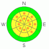
BOTTOM LINE
Danger by aspect and elevation on slopes approaching 35° or steeper.
(click HERE for tomorrow's danger rating)
|

Danger Rose Tutorial
|
In steep, rocky, mid and upper elevation terrain the stability pattern is complicated and there are pockets of CONSIDERABLE (Level 3) avalanche danger on slopes that face northwest through southeast, particularly those with a shallow snowpack. Dangerous human triggered slides which break into weak snow near the ground are probable in this type of terrain.
On steep, upper elevation slopes with recent deposits of wind drifted snow, the avalanche danger is generally MODERATE and human triggered avalanches are possible.
Low elevation terrain and most sun exposed slopes have a LOW avalanche danger. |
|
|
CURRENT CONDITIONS |

|
Under mostly cloudy skies, temperatures are in the mid teens at the trailheads, in the single digits at 10,000’. While it was calm down low, ridgetop winds picked up yesterday afternoon, blowing in the 20’s from the west-southwest through west-northwest with gusts in the upper 30’s along the high ridges. Two inches of snow have fallen in the past 24 hours and despite the overall lack of snow, riding and turning conditions remain quite good. |
|
|
RECENT ACTIVITY |

|
Yesterday, a snowmobiler triggered a hard slab avalanche while side-hilling a steep slope in Super Bowl, but fortunately wasn’t caught. The avalanche was 3’ feet deep, 250’ wide, running about 300’ vertically. This slide occurred on a northeast facing slope at around 10,000’ in elevation. Click here for pictures. Thanks to Harry for the great observation and pictures…. please keep ‘em coming!
New snow sluffs and shallow soft slabs on steep slopes were also reported.
Click here for more snowpack, weather and avalanche observations. |
|
|
THREAT #1 |

|
| WHERE |
PROBABILITY |
SIZE |
TREND |
|
|
|
|
| |
|
|
Over the next
24 hours.
|
|
|
Throughout much of the region, it’s a tale of two snowpacks. Where the snowpack is deep, say four feet or greater, we’re seeing the snow gain strength and it’s becoming more difficult to trigger a slide that breaks to the ground. However, as you know, we trigger deep scary avalanches where the pack is thin and weak, say three feet deep or less. Our problem children, the mid pack facets and weak sugary depth hoar near the ground, have gained little strength and it’s still possible to trigger slides which initiate in the mid pack facets, the snow collapses and then rapidly breaks to the ground, as evidenced by yesterday’s Super Bowl slide. As avalanche guys we talk a lot about shallow snowpack’s, but you don’t have to be an avalanche geek or snow scientist to determine where the pack is shallow. Just take a look around your favorite bowl or chute. If there’s rock, small trees and bushes poking through the snow where they are usually covered up this time of year, that’s a shallow portion of the snowpack and these are likely places where you could still trigger an unmanageable avalanche which breaks into weak snow near the ground. Making matters even trickier is the snow has just enough strength, allowing you to get well out onto the slab before it fails, resulting in a dangerous slide that breaks above you. |
|
|
THREAT #2 |

|
| WHERE |
PROBABILITY |
SIZE |
TREND |

|
|
|
|
| |
|
|
Over the next
24 hours.
|
|
|
Winds picked for a while yesterday and they were strong enough to move snow around, creating shallow drifts along the leeward side of ridges. You’ll find fresh slabs on slopes facing north, northeast and east, along with a cross loaded slope or two facing south and southeast. While mostly manageable in size, once triggered, these slabs can easily break into weaker layers of snow as they descend the slope, triggering a larger slide than you might’ve bargained for. |
|
|
MOUNTAIN WEATHER |

|
Another cloudy, spit and sputter kind of day is on tap as most of the energy of the current storm system dives south of our region. Today’s highs at 8,000’ reach into the mid 20’s, at 10,000’ in the upper teens. Overnight lows once again bottom out in the single digits. Winds remain manageable, out of the northwest, blowing less than 20 mph. Storm totals look meager, but we might be able to squeak 1”-3” of snow today with another 1”-3” tonight. Unsettled weather continues for Sunday with an additional 2”-4” of snow expected. |
|
|
GENERAL ANNOUNCEMENTS |
The information in this advisory expires 24 hours after the date and time posted, but will be updated by 7:00 AM Sunday February 21st, 2010.
If you’re getting out and about and trigger an avalanche or see anything interesting please drop us an email at craig@utahavalanchecenter.org or call 801-231-2170
Come join forecasters from the UAC along with the talented athletes from Boondockers for our second annual Essential Avy and Riding Skills Workshop. Click here for more details.
Also, we've installed two beacon checkers exclusively for snowmobiler's- one at the Noblett's Trailhead, the other at the Bear River Trailhead. Thanks to Backcountry Access, the Bear River Lodge for donating one of the units and the great folks at the National Weather Service for their partnership, support and hard work making this project happen. Click here for a brief tutorial. |
|
|
This information does not apply to developed ski areas or highways where avalanche control is normally done. This advisory is from the U.S.D.A. Forest Service, which is solely responsible for its content. This advisory describes general avalanche conditions and local variations always occur. |
|
This advisory provided by the USDA Forest Service, in partnership with:
The Friends of the Utah Avalanche Center, Utah Division of State Parks and Recreation, Utah Division of Emergency Management, Salt Lake County, Salt Lake Unified Fire Authority and the friends of the La Sal Avalanche Center. See our Sponsors Page for a complete list. |
