SPECIAL ANNOUNCEMENT |
 |
Come join forecasters from the UAC along with the talented athletes from Boondockers for our second annual Essential Avy and Riding Skills Workshop. Click here for more details. |
|
|
BOTTOM LINE
Danger by aspect and elevation on slopes approaching 35° or steeper.
(click HERE for tomorrow's danger rating)
|
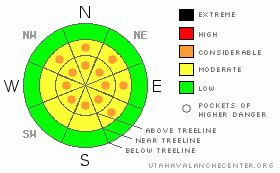
Danger Rose Tutorial
|
The avalanche hazard is CONSIDERABLE (Level 3) on high and mid elevation slopes that face NW, N, NE, E & SE due to a persistent deep slab avalanche hazard. These deep slabs have been failing at the ground naturally in the last few days, and many of these slopes hang in the balance.
Watch for a few lingering wind slabs on slopes that face NE, E, SE & S. Today's light disturbance could build fresh shallow wind slabs on these same aspects. |
|
|
CURRENT CONDITIONS |

|
Temperatures are in the mid teens at upper elevations, while lower elevations are near 20 F this morning at 5 am. Winds remain well behaved after a fairly quiet night, averaging 10 mph out of the NW, gusting to 15.
The riding and turning conditions are excellent at the moment. Storms have been cycling through the Uintas since last Thursday, laying down over an inch of water which translates to over a foot of snow at mid and upper elevations.
The latest conditions, observations and avalanches can always be found here. |
|
|
RECENT ACTIVITY |

|
Large naturals have been the theme as of late, as some of the more pronounced weaknesses on our shady slopes are overloaded. Ted, avalanche hunter, was out yesterday and found this natural in the Moffit Basin on a NE facing aspect off of Moffit Peak.
Craig and I went up Weber Canyon and had a look at some of the action that occurred on Valentines day as the pack adjusted to it's new load.
The sun is climbing ever higher in the sky, producing small point release sluffs as the new snow feels the warmth of the sun for the first time. |
|
|
THREAT #1 |

|
| WHERE |
PROBABILITY |
SIZE |
TREND |
|
|
|
|
| |
|
|
Over the next
24
hours.
|
|
|
This last storm pushed many of the relationships in our dysfunctional snowpack to the breaking point, with most of the action taking place on Northwest through East facing aspects. Many of the slopes which have not avalanched hang in the balance on these same aspects. South facing slopes aren't entirely good to go either. If you're entering steep terrain, you need to be on your game today:
Avoid slopes that are thin. Where-ever you ride, avoid terrain features like rock bands and or small rocks poking out of slopes. These are Mother Nature’s land mines, the places where you are likely to trigger an avalanche.
In places where the pack is deep, say 4' or greater, the hazard is less pronounced as strong snow is helping to bridge over the very weak snow near the ground. Start by tweaking small test slopes before committing to the bigger terrain. Get your avalanche probe out & evaluate the depth of snow on the slope you want to ride. Bang out a few quick snowpit tests so you know what you're getting into. If you don't know how to do these tests, or need a refresher, come take our snowmobile specific avalanche course next weekend.
We're far from being out of the woods at this point. It is possible to trigger the big one out there today which will break as a hard slab failing at the ground. Surviving this type of event would be difficult at best. Keeping your slope angles down and paying attention to changing conditions will help you get home in one piece today. |
|
|
THREAT #2 |

|
| WHERE |
PROBABILITY |
SIZE |
TREND |
|
|
|
|
| |
|
|
Over the next
24
hours.
|
|
|
While I didn't see much for fresh wind slabs yesterday, the Uintas are a big place, and I wouldn't be surprised to find a tired old wind slab considering the erratic behavior of the winds during the storm. These should be a manageable hazard, breaking at or near your machine. The caveat is that once moving, a wind slab could step down into weaknesses lower in the pack triggering a bigger avalanche than you bargained for. |
|
|
MOUNTAIN WEATHER |

|
A very weak & spotty disturbance will move through the Uintas today creating poor visibility, but not much else. We'll see an inch or so of snow today along with winds out of the NW around 10 mph.
A slightly more robust system moves into the area this evening bringing snow showers that should last until Thursday evening. Precipitation totals are a bit hard to pin down at this point, but 3" - 6" of snow seams like a reasonable guess. There is a possibility of storms converging over the forecast area this weekend, but the models are in disagreement. At this point it looks like most of the action will be north & south of us. |
|
|
GENERAL ANNOUNCEMENTS |
The information in this advisory expires 24 hours after the date and time posted, but will be updated by 7:00 AM Saturday February 20th, 2010.
If you’re getting out and about and trigger an avalanche or see anything interesting please drop us an email at craig@utahavalanchecenter.org or call 801-231-2170
Come join forecasters from the UAC along with the talented athletes from Boondockers for our second annual Essential Avy and Riding Skills Workshop. Click here for more details.
Also, we've installed two beacon checkers exclusively for snowmobiler's- one at the Noblett's Trailhead, the other at the Bear River Trailhead. Thanks to Backcountry Access, the Bear River Lodge for donating one of the units and the great folks at the National Weather Service for their partnership, support and hard work making this project happen. Click here for a brief tutorial. |
|
|
This information does not apply to developed ski areas or highways where avalanche control is normally done. This advisory is from the U.S.D.A. Forest Service, which is solely responsible for its content. This advisory describes general avalanche conditions and local variations always occur. |
|
This advisory provided by the USDA Forest Service, in partnership with:
The Friends of the Utah Avalanche Center, Utah Division of State Parks and Recreation, Utah Division of Emergency Management, Salt Lake County, Salt Lake Unified Fire Authority and the friends of the La Sal Avalanche Center. See our Sponsors Page for a complete list. |
