SPECIAL ANNOUNCEMENT |
 |
A Special Avalanche Advisory has been issued for the mountains of northern Utah including the western Uintas. Recent new snow, coupled with strong winds overloaded a variety of weak layers and dangerous human triggered avalanches are likely on steep slopes. |
|
|
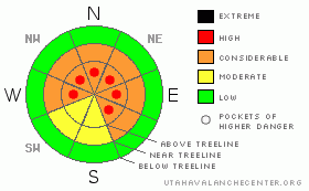
BOTTOM LINE
Danger by aspect and elevation on slopes approaching 35° or steeper.
(click HERE for tomorrow's danger rating)
|
Danger Rose Tutorial
|
At mid and upper elevations the avalanche danger is generally CONSIDERABLE (Level 3) on steep wind drifted slopes and human triggered avalanches are probable. In addition, dangerous human triggered avalanches which break into weak snow near the ground are still probable especially in steep, rocky terrain with a shallow snowpack, on slopes facing northwest through southeast. A CONSIDERABLE (Level 3) avalanche danger still exists on slopes with these characteristics. If your travels take you to the North Slope the avalanche conditions are a bit trickier. A HIGH (Level 4) avalanche danger exists on steep wind loaded slopes and deep, dangerous human triggered avalanches are likely.
Steep wind drifted slopes at lower elevations have a MODERATE (Level 2) avalanche danger and human triggered avalanches are possible.
A LOW (Level 1) avalanche danger exists, especially on sun exposed slopes and those not effected by wind. |
|
|
CURRENT CONDITIONS |

|
A moist, northwest flow remains in place over the region, keeping clouds and a few light snow showers around throughout the day. The North Slope has done well on this flow and storm totals since Wednesday night are just over a foot. Yesterday though, the flow favored the terrain surrounding Trial Lake where 8” of new snow fell during the day. The southern half of the range got skunked on this one and new snow totals are only in the 3”-6” range. Westerly winds yesterday blasted the ridges, gusting to 50 mph, but have relaxed somewhat, switching to the northwest and are now blowing 15-20 mph. Temperatures are in the mid teens at the trailheads and upper elevations. Riding and turning conditions are somewhat dense and inverted and your best bet is to seek wind sheltered terrain. |
|
|
RECENT ACTIVITY |

|
Ted spotted some steep roadbanks yesterday along the Mirror Lake Highway that released naturally and with slope cuts, breaking into weak snow near the ground. Click here for more snowpack and avalanche observations. |
|
|
THREAT #1 |

|
| WHERE |
PROBABILITY |
SIZE |
TREND |
|
|
|
|
| |
|
|
Over the next
24 hours.
|
|
|
For the past few weeks the snowpack has been in a state of equilibrium. However, yesterday’s strong winds combined with a good shot of snow and close to an inch of water since Thursday is beginning to overload and stress the weak, sugary layers of our snowpack. While some steep terrain probably shed a few layers of snow throughout the storm, none of them ripped off their winter coats and I think there are plenty of steep slopes hanging in the balance waiting for a trigger like us to come along and kick the legs out from underneath them. Unfortunately it’s not all that cut and dry and in many places the January storm snow, which is now the mid portion of our snowpack, can handle a little weight before failing, giving us a false sense of snow stability. When these slopes do avalanche however, they’ll take the entire seasons’ snowpack with them, creating a very dangerous avalanche. Today you’ll need to avoid steep terrain, especially slopes that have remained thin and rocky all season. Remember- we trigger deep, dangerous avalanches from thin portions of the snowpack, not where it’s thick and strong. It’s not full on avapocalypse out there today and there are plenty of slopes you can ride safely. However, even if you’re on relatively low angle slopes be aware of steeper terrain above and adjacent to where you’re riding and carefully assess each slope on an individual basis. |
|
|
THREAT #2 |

|
| WHERE |
PROBABILITY |
SIZE |
TREND |

|
|
|
|
| |
|
|
Over the next
24 hours.
|
|
|
Strong ridgetop winds have been all over the map the past few days, whipping the new snow into fresh drifts, not only on the leeward side of ridges, but further downslope as well. Conditions have changed in the past 24 hours and yesterdays manageable slabs could get quickly out of hand once triggered today- stepping down into weaker layers of snow as they descend a slope, creating a larger slide than you might’ve bargained for. Terrain features like steep, rocky breakovers would be likely suspects. Don’t let your guard down and to continue gather information about the snows stability- stomp on road cuts and test slopes and utilize slope cuts to see how the snow is reacting before committing to big terrain. |
|
|
MOUNTAIN WEATHER |

|
A somewhat moist, northwest flow continues today, giving us mostly cloudy skies and a flurry or two. Northwest winds remain in the 15-25 mph range, though a few gusts in the 40’s wouldn’t be out of the question. High temperatures reach into the mid 30’s at 8,000’ and upper 20’s at 10,000’. Overnight lows dip into the mid teens. A weak storm moves through the region tonight and another one is expected late Monday, though neither looks too impressive. High pressure tries to build for the mid portion of the week with a stronger system affecting the area Thursday. |
|
|
GENERAL ANNOUNCEMENTS |
The information in this advisory expires 24 hours after the date and time posted, but will be updated with a holiday forecast by 7:00 AM Tuesday February 15th, 2010.
If you’re getting out and about and trigger an avalanche or see anything interesting please drop us an email at craig@utahavalanchecenter.org or call 801-231-2170
Come join forecasters from the UAC along with the talented athletes from Boondockers for our second annual Essential Avy and Riding Skills Workshop. Click here for more details.
Also, we've installed two beacon checkers exclusively for snowmobiler's- one at the Noblett's Trailhead, the other at the Bear River Trailhead. Thanks to Backcountry Access, the Bear River Lodge for donating one of the units and the great folks at the National Weather Service for their partnership, support and hard work making this project happen.Click here for a brief tutorial. |
|
|
This information does not apply to developed ski areas or highways where avalanche control is normally done. This advisory is from the U.S.D.A. Forest Service, which is solely responsible for its content. This advisory describes general avalanche conditions and local variations always occur. |
|
This advisory provided by the USDA Forest Service, in partnership with:
The Friends of the Utah Avalanche Center, Utah Division of State Parks and Recreation, Utah Division of Emergency Management, Salt Lake County, Salt Lake Unified Fire Authority and the friends of the La Sal Avalanche Center. See our Sponsors Page for a complete list. |
