SPECIAL ANNOUNCEMENT |
 |
Come join forecasters from the UAC along with the talented athletes from Boondockers for our second annual Essential Avy and Riding Skills Workshop. Click here for more details.
Also, we've installed a beacon checker exclusively for snowmobiler's at the Noblett's Trailhead. Click here for a brief tutorial. Thanks to Backcountry Access and the great folks at the National Weather Service for their partnership, support and hard work making this project happen. |
|
|
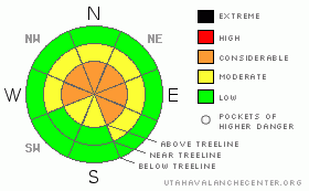
BOTTOM LINE
Danger by aspect and elevation on slopes approaching 35° or steeper.
(click HERE for tomorrow's danger rating)
|
Danger Rose Tutorial
|
At upper elevations the avalanche danger is CONSIDERABLE (Level 3) on steep wind drifted slopes and human triggered soft slab avalanches are probable. In addition, dangerous human triggered avalanches are still probable especially in steep, rocky terrain with a shallow snowpack, on slopes facing northwest through southeast. A CONSIDERABLE (Level 3) avalanche danger still exists on slopes with these characteristics.
On steep wind drifted slopes at mid elevations a MODERATE (Level 2) avalanche danger exists and human triggered avalanches are possible.
A LOW (Level 1) avalanche danger exists in lower elevation terrain, especially on sun exposed slopes and those not effected by wind. |
|
|
CURRENT CONDITIONS |

|
The last in a series of weak weather systems is working its way into northern Utah this morning. Skies are mostly cloudy and temperatures are in the low to mid 20’s. Winds have been rather active the past 24 hours, gusting into the low 50’s yesterday out of west and southwest then switching to the west-northwest early this morning averaging 25 mph with gusts in the mid 30’s. Storm totals aren’t overly impressive, but the little shots of snow are adding up and most upper elevation terrain received close to 6” of new snow since Thursday. Riding and turning conditions remain quite good, especially on wind sheltered slopes. |
|
|
RECENT ACTIVITY |

|
No news of the weird, though shallow soft slabs up to a foot deep were easily triggered, near and along ridgelines yesterday.
Click here for more snowpack observations.
Remember- your snow and avalanche observations can help save another riders life. If you see avalanche activity, please give us a shout with the details. I can be reached at 801-231-2170 or craig@utahavalanchecenter.org |
|
|
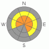
THREAT #1 |

|
| WHERE |
PROBABILITY |
SIZE |
TREND |
|
|
|
|
| |
|
|
Over the next
24 hours.
|
|
|
The western Uintas are an interesting range- high elevation peaks, cold temperatures and less average snowfall than our Wasatch neighbors all add up to create a weak, shallow and notoriously dangerous snowpack. Sure, we’re use to these conditions… heck it’s what we’re famous for! However, this winter even our snowpack has remained unusually thin and the late December dry spell combined with record cold temperatures didn’t help matters a bit. Our snowpack is not only vertically challenged it’s structurally challenged as well; especially in steep, rocky, mid and upper elevation terrain where snow depths are right around 3’ or less. (Check out Grant's snowpit observations from earlier this week here.) This is exactly the type of terrain people are starting to nose into and it’s the kind of place where you could still trigger a dangerous avalanche that breaks on weak snow near the ground. Giving us a false sense of security is a mid-pack structure that keeps us floating in the new fluffy snow whether on our skis, board or sled. However, a simple snowpit with either your hands or shovel easily reveals not only what you’re riding in, but also what you’re riding on as well. It’s easy to see why we continue to have concerns about the snowpack- the basic structure of our pack is inherently dangerous. If you want to ride steep terrain safely, get onto slopes you know already slid big during the January avalanche cycle. |
|
|
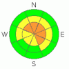
THREAT #2 |

|
| WHERE |
PROBABILITY |
SIZE |
TREND |
|
|
|
|
| |
|
|
Over the next
24 hours.
|
|
|
Strong ridgetop winds the past few days whipped the new snow into fresh drifts which are found on the leeward side of ridges and around terrain features like chutes and gullies. While these soft slabs are mostly manageable, breaking at or below your skis or sled, they have the possibility of stepping down into weaker layers of snow as they descend a slope, creating a larger slide than you might’ve bargained for. Terrain features like steep, rocky breakovers would be likely suspects. Today you'll want to continue gathering information about the snows stability- stomp on road cuts and test slopes and utilize slope cuts to see how the snow is reacting before committing to big terrain. |
|
|
MOUNTAIN WEATHER |

|
A moist northwest flow should usher in scattered snow showers throughout the day with accumulations in the 2”-4” range. High temperatures reach into the low 30’s at 8,000’ and upper 20’s at 10,000’. Overnight lows under clearing skies dive into the single digits. West and Northwest winds are gonna be an issue today, blowing in the 20’s and 30’s with gusts near 50 mph along the high ridges. Partly cloudy skies and warming temperatures are on tap for Sunday and Monday with some uncertainty for a storm developing around Tuesday… we’ll have a better handle on that one for tomorrow’s update. |
|
|
GENERAL ANNOUNCEMENTS |
The information in this advisory expires 24 hours after the date and time posted, but will be updated by 7:00 AM Sunday February 14th, 2010.
If you’re getting out and about and trigger an avalanche or see anything interesting please drop us an email at craig@utahavalanchecenter.org or call 801-231-2170 |
|
|
This information does not apply to developed ski areas or highways where avalanche control is normally done. This advisory is from the U.S.D.A. Forest Service, which is solely responsible for its content. This advisory describes general avalanche conditions and local variations always occur. |
|
This advisory provided by the USDA Forest Service, in partnership with:
The Friends of the Utah Avalanche Center, Utah Division of State Parks and Recreation, Utah Division of Emergency Management, Salt Lake County, Salt Lake Unified Fire Authority and the friends of the La Sal Avalanche Center. See our Sponsors Page for a complete list. |
