SPECIAL ANNOUNCEMENT |
 |
Come join forecasters from the UAC along with the talented athletes from Boondockers for our second annual Essential Avy and Riding Skills Workshop. Click here for more details.
Also, we've installed a beacon checker exclusively for snowmobiler's at the Noblett's Trailhead. Click here for a brief tutorial. Thanks to Backcountry Access and the great folks at the National Weather Service for their partnership, support and hard work making this project happen. |
|
|
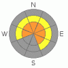
BOTTOM LINE
Danger by aspect and elevation on slopes approaching 35° or steeper.
(click HERE for tomorrow's danger rating)
|

Danger Rose Tutorial
|
At mid and upper elevations the avalanche danger is MODERATE (Level 2) on steep wind drifted slopes and human triggered avalanches are possible. Be aware that within this elevation band a CONSIDERABLE (Level 3) avalanche danger also exists, especially in steep, rocky terrain with a shallow snowpack, on slopes facing northwest through southeast. While not widespread and pockety in nature, dangerous human triggered avalanches are still probable.
A LOW (Level 1) avalanche danger exists in lower elevation terrain, especially on sun exposed slopes and those not effected by wind. |
|
|
CURRENT CONDITIONS |

|
High, thin clouds are moving out of the region early this morning as high pressure begins to build. West and northwest winds remain reasonable, blowing 10-20 mph along the ridges, gusting to 25 mph near the high peaks. It's crisp out there this morning with current trailhead temperatures barely cracking into the double digits, while the upper elevations are closer to 5 degrees. The automated weather station at Mirror Lake is currently reporting a finger numbing -9 degrees. Despite the lack of snow, riding and turning conditions remain quite good, though with only four feet of total snow depth, much of our terrain remains thin. |
|
|
RECENT ACTIVITY |

|
Yesterday, Ted spotted two recent snowmobile triggered slides. One in Super Bowl that was 3' deep, 350' wide, running about 400' vertical. The other, on Double Hill was 3' deep, 150' wide, running 250' vertical. Both avalanches were triggered in upper elevation, steep, rocky terrain with a weak, shallow snowpack. Since no one reported the slides to us, we can only speculate that the riders came out on top and unscathed. Click here for more details.
Remember- your snow and avalanche observations can help save another riders life. If you see avalanche activity, please give us a shout with the details. I can be reached at 801-231-2170 or craig@utahavalanchecenter.org |
|
|
THREAT #1 |

|
| WHERE |
PROBABILITY |
SIZE |
TREND |
|
|
|
|
| |
|
|
Over the next
24 hours.
|
|
|
It's been two weeks since the dust of the big January storm cycle settled and you'd think that by now our snowpack would've adjusted, healing over time and we'd be good to go. Sure, this might be the case in the majority of our terrain, however there are still places where you could trigger a slide today and the latest round of human triggered avalanches share a common denominator we've been highlighting the past couple of weeks- they occurred in steep rocky terrain, with a weak, shallow snowpack. Check out Grant's snowpit observations from yesterday here.
Let's face it, the Uinta snowpack is historically more shallow than our Wasatch neighbors and remains unstable for longer periods of time even on a good winter... but this year is even more unusual. The snowpack is atypically thin for the first week of February and the overall structure remains quite weak. Complicating the stability pattern is the pockety nature of where you can initiate an avalanche. Of course you can rides miles and miles of terrain and not trigger a slide and think to yourself "What are these avalanche guys talking about?" However, if your travels take you into mid and upper elevation terrain that's thin and rocky, you can bet the snowpack is weak.... exactly the type of place you can still trigger a deep, dangerous slide today. Your best bet is to avoid terrain like this a go rip the lower angle slopes and meadows or ride steep terrain on slopes that already avalanched. |
|
|
THREAT #2 |

|
| WHERE |
PROBABILITY |
SIZE |
TREND |
|
|
|
|
| |
|
|
Over the next
24 hours.
|
|
|
There's a few shallow wind slabs along the leeward side of upper elevation ridges that may still be sensitive to the weight of a rider. While mostly manageable in size, these fresh drifts can break into weaker snow as they descend the slope, creating a larger slide than you might have bargained for. You can easily determine the snows stability by tweaking small test slopes and road cuts similar to what you wanna ride. Get some solid information and see how they're reacting before getting into big terrain. |
|
|
MOUNTAIN WEATHER |

|
A storm system diving to the south will keep some low level clouds over the region throughout the day with the possibility of a flurry or two. Winds should remain well behaved, out of the west and southwest, blowing 10-20 mph along the ridges. Temperatures reach into the upper 20's at 8,000' and near 20 degrees at 10,000'. Overnight lows under clearing skies dive into the single digits. High pressure builds for the latter half of the week, giving us partly cloudy skies and warming temperatures. There are no big storms in sight. |
|
|
GENERAL ANNOUNCEMENTS |
The information in this advisory expires 24 hours after the date and time posted, but will be updated by 7:00 AM Saturday February 13th, 2010.
If you’re getting out and about and trigger an avalanche or see anything interesting please drop us an email at craig@utahavalanchecenter.org or call 801-231-2170 |
|
|
This information does not apply to developed ski areas or highways where avalanche control is normally done. This advisory is from the U.S.D.A. Forest Service, which is solely responsible for its content. This advisory describes general avalanche conditions and local variations always occur. |
|
This advisory provided by the USDA Forest Service, in partnership with:
The Friends of the Utah Avalanche Center, Utah Division of State Parks and Recreation, Utah Division of Emergency Management, Salt Lake County, Salt Lake Unified Fire Authority and the friends of the La Sal Avalanche Center. See our Sponsors Page for a complete list. |
