SPECIAL ANNOUNCEMENT |
 |
A SPECIAL AVALANCHE ADVISORY CONTINUES FOR ALL THE MOUNTAINS OF UTAH. DANGEROUS AVALANCHE CONDITIONS PERSIST ON STEEP SNOW COVERED SLOPES IN THE MOUNTAINS OF UTAH. BACK COUNTRY TRAVELERS AND SNOWMOBILES CAN TRIGGER LARGE DEEP AVALANCHES BREAKING NEAR THE GROUND...WHICH MAY BE UNSURVIVABLE. BACK COUNTRY TRAVELERS SHOULD AVOID TRAVEL ON AND BELOW STEEP SLOPES. THIS ADVISORY DOES NOT INCLUDE SKI AREAS OR HIGHWAYS WHERE AVALANCHE CONTROL IS NORMALLY DONE.
Thanks to all who joined the Beacon Basin work party yesterday at the Noblett's Trailhead. I appreciate all the help from Chief, Zeke, Doug, Dan, Phatty, the Boondockers Crew and of course Grant... you guys are awesome! |
|
|
BOTTOM LINE
Danger by aspect and elevation on slopes approaching 35° or steeper.
(click HERE for tomorrow's danger rating)
|
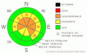
Danger Rose Tutorial
|
At mid and upper elevations the avalanche danger is CONSIDERABLE (Level 3) today, especially in steep, rocky terrain, facing the north half of the compass and dangerous human triggered avalanches are probable.
A MODERATE (Level 2) avalanche danger exists on steep wind drifted slopes at mid and upper elevations and human triggered avalanches are possible.
A LOW (Level 1) avalanche danger exists in lower elevation terrain, especially on sun exposed slopes and those not effected by wind. |
|
|
CURRENT CONDITIONS |

|
A storm system sliding north of the region deposited an evenly distributed 2" of medium density snow overnight. Eclipsing the new snow totals however, are the strong, south and southwest ridgetop winds. They began increasing around 10:00 last night and have been averaging 20-30 mph with gusts near 50 mph along the high peaks. Temperatures are in the upper teens at 10,000' and low 20's at 8,000'. Riding and turning conditions remain quite good, though recent warm temperatures created crusts on most sunny slopes. |
|
|
RECENT ACTIVITY |

|
Two backcountry skiers have been killed in separate avalanche accidents this week and it saddens me to report yet another avalanche accident which occurred Friday near Grandview Peak involving a snowmobiler. Click here for details.
Avalanches everywhere... both natural and human triggered, failing on weak snow near the ground taking out the entire seasons snowpack. Click here for more details. |
|
|
THREAT #1 |

|
| WHERE |
PROBABILITY |
SIZE |
TREND |

|
|
|
|
| |
|
|
Over the next
24 hours.
|
|
|
Large, dangerous and unmanageable avalanches continue to make headline news. These are unusual avalanche conditions for Utah because normally we have a self healing snowpack. It snows, you wait a few days and then you can get after it… this is definitely NOT the case this season.
I must say however, Grant, Ted and I were pretty surprised yesterday by the lack of human triggered avalanches, especially given the amount of terrain tested and ridden by a slew of people. While the snowpack is starting to heal where it's deep and strong, don't let that lure you into a false sense of snowpack stability. The overall structure of our snowpack is poor, particularly in steep, mid and upper elevation, rocky terrain where the pack remains shallow and weak. In addition, old crown lines are starting to get filled in and it's getting harder to tell what slid during the big January storm and what slopes remained intact, further complicating the stability pattern. While they may not be as widespread or sensitive as a few days ago, you can still trigger deep, dangerous avalanches today and the outcome is sure to be devastating. Please think about the consequences of your terrain choices! |
|
|
THREAT #2 |

|
| WHERE |
PROBABILITY |
SIZE |
TREND |

|
|
|
|
| |
|
|
Over the next
24 hours.
|
|
|
Newly formed wind drifts along the leeward side of ridges will be shallow, yet sensitive to the weight of a rider today. This morning these slabs are mostly manageable, breaking at our feet or just below us, but could become more widespread and sensitive as the day wares on. Be alert to changing snow and weather conditions and avoid any fat, rounded, pillows of snow. |
|
|
MOUNTAIN WEATHER |

|
Today's storm system will impact the northern third of the state, though the Uintas should pick up 2"-4" of snow throughout the day. Temperatures will remain cool with 8,000' highs only reaching into the mid 20's and at 10,000' near 20 degrees. Overnight lows under clearing skies will dive into the single digits. It'll be breezy along the ridges and peaks, blowing out of the southwest, 20-30 mph with gusts in the upper 40's. High pressure builds overnight, remaining in place through late Tuesday, giving us partly cloudy skies and warming temperatures. A weak storm grazes the region Wednesday with the possibility of something stronger later in the week. |
|
|
GENERAL ANNOUNCEMENTS |
The information in this advisory expires 24 hours after the date and time posted, but will be updated by 7:00 AM Wednesday February 3rd, 2010.
If you’re getting out and about and trigger an avalanche or see anything interesting please drop us an email at craig@utahavalanchecenter.org or call 801-231-2170 |
|
|
This information does not apply to developed ski areas or highways where avalanche control is normally done. This advisory is from the U.S.D.A. Forest Service, which is solely responsible for its content. This advisory describes general avalanche conditions and local variations always occur. |
|
This advisory provided by the USDA Forest Service, in partnership with:
The Friends of the Utah Avalanche Center, Utah Division of State Parks and Recreation, Utah Division of Emergency Management, Salt Lake County, Salt Lake Unified Fire Authority and the friends of the La Sal Avalanche Center. See our Sponsors Page for a complete list. |
