SPECIAL ANNOUNCEMENT |
 |
Special Avalanche Advisory
Unusually dangerous conditions exist today and through the weekend for most of the mountains in Utah. Many slope lie hanging in the balance waiting for a trigger, such as the weight of a person or snowmobile. These avalanches will be unusually large and mostly unsurvivable. Backcountry travelers should avoid all slopes approaching 35 degrees and steeper that face northwest, north, northeast, east and southeast at mid and upper elevations.
Also, we will be installing Beacon Basin today around 11:00 at the Noblett's Trailhead and could use a couple o' extra hands. Swing by, lend a hand and we'll help you hone your beacon skills too... what a deal!
|
|
|
BOTTOM LINE
Danger by aspect and elevation on slopes approaching 35° or steeper.
(click HERE for tomorrow's danger rating)
|
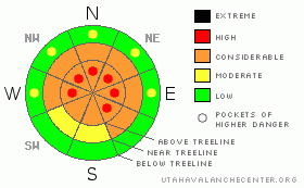
Danger Rose Tutorial
|
At mid and upper elevations the avalanche danger is CONSIDERABLE (Level 3) today, especially in steep, rocky terrain, facing the north half of the compass and dangerous human triggered avalanches are possible. In addition, pockets of HIGH danger still exist in the wind zone at upper elevations on steep, wind drifted slopes. Avalanches triggered today will be deep, wide and likely unsurvivable.
A LOW avalanche danger exists in lower elevation terrain, especially on sun exposed slopes and those not effected by wind. |
|
|
CURRENT CONDITIONS |

|
High pressure is moving east today allowing clouds to stream into the region. Winds are light and southwesterly, blowing 10-20 mph along the ridges. Temperatures are inverted and warmer as you gain elevation. At 8,000’ it’s in the upper teens and in the mid 20’s at 10,000’. Riding and turning conditions are quite good and you can have fun on low angle terrain.
|
|
|
RECENT ACTIVITY |

|
Two backcountry skiers have been killed in separate avalanche accidents this week and it saddens me to report yet another avalanche accident which occurred yesterday near Grandview Peak involving a snowmobiler. Click here for details.
Avalanches everywhere... both natural and human triggered, failing on weak snow near the ground taking out the entire seasons snowpack. Click here for more details. |
|
|
THREAT #1 |

|
| WHERE |
PROBABILITY |
SIZE |
TREND |

|
|
|
|
| |
|
|
Over the next
24 hours.
|
|
|
Large, dangerous and unmanageable avalanches continue to make headline news. These are unusual avalanche circumstances for Utah because normally we have a self healing snowpack. It snows, you wait a few days and then you can get after it… this is definitely NOT the case this season. Why is it so strange right now, well here’s the deal. The latter half of December was extremely dry and very cold. This combination created weak sugary snow at the surface, what we call near surface facets, which then got buried and preserved. Two weeks ago a series of storms slammed our mountains with up to 4’ feet of snow, but since the storm came in waves, the fragile weak snow was able to temporarily adjust and we didn’t see a lot of natural avalanche activity. Now, many slopes hang in the balance just waiting for a trigger like us to come along and kick the legs out from under all this storm snow.
Don’t let sunshine and fresh powder lure you into a false sense of security today. Theses aren’t the types of avalanches we can outrun. They break above us, at the bottom of the slope or when we’re mid-slope climbing or side-hilling. Once triggered, today’s avalanches will break into weaker snow near the ground, producing a wide, deep and deadly slide. If you want to return home safely at the end of the day your best bet is to continue avoiding steep terrain and ride in the low angle meadows where the snow remains cold and light. Even if you’re on relatively flat terrain, be aware of steep slopes above and adjacent to where you’re riding.
Please think about the consequences of your terrain choices!
|
|
|
MOUNTAIN WEATHER |

|
High pressure moves east today as a weakening Pacific storm slides into the region. Today we can expect increasing afternoon clouds and continued mild temperatures with highs at 8,000’ in the upper 30’s and at 10,000’ near freezing. Overnight lows dip into the mid teens. Southwest winds pick up as the day progresses and should blow 10-20 mph with gusts in the low 30’s along the high ridges. Snow develops tonight and we can expect 1”-3” by Sunday morning. Colder air ushers in snow showers on Sunday with another couple of inches expected. A somewhat moist southwest flow develops over the area late Monday, persisting through the week.
|
|
|
GENERAL ANNOUNCEMENTS |
The information in this advisory expires 24 hours after the date and time posted, but will be updated by 7:00 AM Sunday January 31th, 2010.
If you’re getting out and about and trigger an avalanche or see anything interesting please drop us an email at craig@utahavalanchecenter.org or call 801-231-2170 |
|
|
This information does not apply to developed ski areas or highways where avalanche control is normally done. This advisory is from the U.S.D.A. Forest Service, which is solely responsible for its content. This advisory describes general avalanche conditions and local variations always occur. |
|
This advisory provided by the USDA Forest Service, in partnership with:
The Friends of the Utah Avalanche Center, Utah Division of State Parks and Recreation, Utah Division of Emergency Management, Salt Lake County, Salt Lake Unified Fire Authority and the friends of the La Sal Avalanche Center. See our Sponsors Page for a complete list. |
