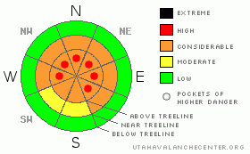
BOTTOM LINE
Danger by aspect and elevation on slopes approaching 35° or steeper.
(click HERE for tomorrow's danger rating)
|
Danger Rose Tutorial
|
At mid and upper elevations the avalanche danger is CONSIDERABLE (Level 3) today, especially in steep, rocky terrain, facing the north half of the compass and dangerous human triggered avalanches are possible. In addition, pockets of HIGH danger still exist in the wind zone on steep, wind drifted slopes. Avalanches triggered today will be deep, wide and likely unsurvivable.
The avalanche danger is generally MODERATE in mid elevation terrain with recent deposits of wind drifted snow.
A LOW avalanche danger exists in lower elevation terrain, especially on sun exposed slopes and those not effected by wind.
|
|
|
CURRENT CONDITIONS |

|
A weak storm brushing by the region today is giving us mostly cloudy skies, a snow shower or two and light winds. Temperatures are currently in the mid teens at 10,000' and low 20's at the trailheads. Winds are blowing west and southwest 10-15 mph along the ridges. An inch of new snow fell in the past 24 hours and average upper elevation snow depths are right around 50". |
|
|
RECENT ACTIVITY |

|
Plenty of large, bone and tree snapping avalanches throughout the range.... both natural and human triggered. Click here to view pictures. |
|
|
THREAT #1 |

|
| WHERE |
PROBABILITY |
SIZE |
TREND |
|
|
|
|
| |
|
|
Over the next
24 hours.
|
|
|
We're entering a deceptively tricky and delicate stage in our snowpacks history. While there's evidence of a decent natural avalanche cycle, especially in terrain that had a weak shallow snowpack prior to last weeks big storm, it's not like widespread avalanche events we've seen in the past. Given the current structure of our snowpack it's a crap shoot. As the snowpack gains strength and starts to adjust it'll get harder to trigger slides, but the ones you do initiate will be deep, wide and dangerous. Click here for a recent snowpack tutorial and snow stability test.
Looking at where and how people are riding the past few days simply blows me away. Sure, given the variability of our snowpack you can get away with center-punching some big slopes without incident, but it's like swimming in a tank full of sharks... you're eventually gonna be looking down the mouth of a Great White and it'll be too late to turn around. These are exactly the type of snowpack conditions that lead to most fatal avalanche accidents in the western Uinta Mountains. This doesn't mean you can't ride and still have a blast. However, it does mean you should think about the consequences of your terrain choices and stick to low angle meadows where the powder is over-the-hood and in your face. |
|
|
THREAT #2 |

|
| WHERE |
PROBABILITY |
SIZE |
TREND |
|
|
|
|
| |
|
|
Over the next
24 hours.
|
|
|
Winds were all over the map during last weeks storm and there's probably a wind slab or two that'll remain sensitive to the weight of a rider. These are becoming a little more well behaved, but once triggered they can break into weaker snow in the mid portion of our snowpack. Be on the lookout for and avoid any fat, rounded pillow of snow, especially in upper elevation leeward terrain. |
|
|
MOUNTAIN WEATHER |

|
A weak storm system moves through the region today, bringing mostly cloudy skies with an inch or two of snow. Highs reach into the low 30's at 8,000' and upper 20's at 10,000'. Overnight lows under clearing skies dive into the mid teens. Winds should remain light and northerly, blowing less than 20 mph. High pressure builds for the latter half of the week producing partly cloudy skies and warming temperatures. |
|
|
GENERAL ANNOUNCEMENTS |
The information in this advisory expires 24 hours after the date and time posted, but will be updated by 7:00 AM Saturday January 30th, 2010.
If you’re getting out and about and trigger an avalanche or see anything interesting please drop us an email at craig@utahavalanchecenter.org or call 801-231-2170 |
|
|
This information does not apply to developed ski areas or highways where avalanche control is normally done. This advisory is from the U.S.D.A. Forest Service, which is solely responsible for its content. This advisory describes general avalanche conditions and local variations always occur. |
|
This advisory provided by the USDA Forest Service, in partnership with:
The Friends of the Utah Avalanche Center, Utah Division of State Parks and Recreation, Utah Division of Emergency Management, Salt Lake County, Salt Lake Unified Fire Authority and the friends of the La Sal Avalanche Center. See our Sponsors Page for a complete list. |
