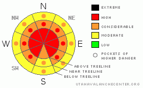
BOTTOM LINE
Danger by aspect and elevation on slopes approaching 35° or steeper.
(click HERE for tomorrow's danger rating)
|
Danger Rose Tutorial
|
At mid and upper elevations the avalanche danger is HIGH (Level 4) and human triggered avalanches are probable. Avalanches triggered today will be large, dangerous and likely un-survivable. A CONSIDERABLE (Level 3) avalanche danger exists on steep mid & low elevation slopes with recent deposits of wind drifted snow.
|
|
|
CURRENT CONDITIONS |

|
Under mostly cloudy skies, temperatures are in the mid and upper teens. Winds switched to the southeast early this morning and are blowing 15-30 mph along the ridges. A trace of snow fell overnight and average snow depths at the upper elevations are close to 50". Last weeks storm totals stacked up over three feet of snow and nearly 2.5 inches of water. |
|
|
RECENT ACTIVITY |

|
I'm sorry to report an avalanche fatality from the backcountry near Snowbasin which occurred on Sunday. Click here for more details. Our prayers and condolences go out to the friends and family of Todd Bell.
Closer to home- Grant and I went rode out of Noblett's yesterday and we counted no less than half a dozen large, bone snapping avalanches.... both natural and human triggered.
Booming collapses and "whoomphing" continues to be the norm throughout the range.
Click here for recent Uinta observations. |
|
|
THREAT #1 |

|
| WHERE |
PROBABILITY |
SIZE |
TREND |
|
|
|
|
| |
|
|
Over the next
24 hours.
|
|
|
Throughout the storm cycle, winds blew out of the south, southeast, southwest, northwest and west, transporting an amazing amount of snow onto leeward slopes, not only up high in the wind zone, but down into mid and low elevation terrain as well. Yesterday the winds switched to the northwest and now they're back to the southeast. You get the idea... nearly every aspect is wind loaded now. Avalanches triggered in the newly formed wind drifts can break into weaker layers of snow, now buried deep in the snowpack, producing larger, more dangerous avalanches than you might expect. |
|
|
THREAT #2 |

|
| WHERE |
PROBABILITY |
SIZE |
TREND |

|
|
|
|
| |
|
|
Over the next
24 hours.
|
|
|
While the avalanche warning has expired, we're not even close to being out of the woods just yet and avalanche conditions will get deceptively trickier the next few days. As the snowpack gains strength avalanches become more difficult to trigger, but once initiated they're likely to be deep, dangerous and unsurvivable. (Click here for a brief snowpack tutorial). Our current problem child is the weak near surface facets formed during the December dry spell and these sugary crystals are now buried and preserved in the mid portion of our snowpack. As a a matter of fact, our snowpit stability tests reveal this persistent buried weak layer isn't well behaved and nearly all the recent avalanche activity revolves around this notoriously dangerous weak layer. Many steep slopes throughout the range hang in the balance, just waiting for a rider to come along and knock the legs out from underneath it. In addition, avalanches are still being triggered on the "flats" at the bottom of steep slopes, so you need to be aware of steep terrain above and adjacent to where you're riding even when you're playing on relatively low angle slopes. These are exactly the type of snowpack conditions that lead to most fatal avalanche accidents in the western Uinta Mountains. There’s no reason to pull on the dogs tail. Have some patience, let the snowpack heal and get after it when the avalanche conditions are manageable. We have a dangerous snowpack and avalanches triggered today can break into weak snow near the ground, resulting in a deep and unsurvivable slide. |
|
|
MOUNTAIN WEATHER |

|
A weak storm system moves through the region today, bringing mostly cloudy skies with a couple inches of snow. Highs reach into the low and mid 20's. Winds switch to the west and northwest, relaxing somewhat later in the day. Another storm system moves through the region tonight and Wednesday, but splits and benefits the southern half of the state. High pressure builds for the latter half of the week. |
|
|
GENERAL ANNOUNCEMENTS |
The information in this advisory expires 24 hours after the date and time posted, but will be updated by 7:00 AM Wednesday January 27th, 2010.
If you’re getting out and about and trigger an avalanche or see anything interesting please drop us an email at craig@utahavalanchecenter.org or call 801-231-2170 |
|
|
This information does not apply to developed ski areas or highways where avalanche control is normally done. This advisory is from the U.S.D.A. Forest Service, which is solely responsible for its content. This advisory describes general avalanche conditions and local variations always occur. |
|
This advisory provided by the USDA Forest Service, in partnership with:
The Friends of the Utah Avalanche Center, Utah Division of State Parks and Recreation, Utah Division of Emergency Management, Salt Lake County, Salt Lake Unified Fire Authority and the friends of the La Sal Avalanche Center. See our Sponsors Page for a complete list. |
