AVALANCHE WARNING »
Dangerous avalanche conditions are occuring or are imminent.
Backcountry travel in avalanche terrain is not recommended.
|
 |
Notice: THE AVALANCHE WARNING CONTINUES FOR THE ALL THE MOUNTAINS OF UTAH. HEAVY SNOWFALL AND STRONG WINDS HAVE OVERLOADED A VERY WEAK PRE-EXISTING SNOWPACK. LARGE UNSURVIVABLE AVALANCHES WILL CONTINUE TO BE SENSITIVE TO HUMAN TRIGGERING. THESE ARE VERY UNUSUAL AND DANGROUS CONDITIONS. BACKCOUNTRY TRAVEL IS NOT RECOMMENDED. AVOID BEING ON OR UNDERNEATH ANY STEEP SLOPES, EVEN PERCEIVED MINOR SLOPES IN THE FOOTHILLS OR MOUNTAIN RESIDENTIAL AREAS. THIS WARNING DOES NOT INCLUDE SKI AREAS OR HIGHWAYS WHERE AVALANCHE CONTROL IS NORMALLY DONE. |
|
|
BOTTOM LINE
Danger by aspect and elevation on slopes approaching 35° or steeper.
(click HERE for tomorrow's danger rating)
|

Danger Rose Tutorial
|
At mid and upper elevations the avalanche danger is HIGH (Level 4). Both natural and human triggered avalanches are probable. Avalanches triggered today will be large, dangerous and likely un-survivable. A CONSIDERABLE (Level 3) avalanche danger exists on steep mid & low elevation slopes with recent deposits of wind drifted snow.
|
|
|
CURRENT CONDITIONS |

|
No new snow fell overnight, but storm totals this past week stacked up over three feet of snow and close to 2.5 inches of water. Westerly winds have been relentless the past 24 hours, averaging 30-40 mph with gusts in the 60's. They've relaxed a bit overnight and are currently blowing 20-30 mph, gusting into the 40's along the high ridges. Temperatures are in the single digits. |
|
|
RECENT ACTIVITY |

|
I'm sorry to report an avalanche fatality from the backcountry near Snowbasin which occurred yesterday. Click here for more details. Our prayers and condolences go out to the friends and family of Todd Bell.
Closer to home- Friday, one large, bone snapping natural avalanche was reported from upper Weber Canyon occurring on a steep, wind loaded northeast facing slope. The slide was 3’-5’ deep, 250’-300’ wide and failed on weak snow near the ground pulling out the entire season’s snowpack.
On Saturday, a very large avalanche was remotely triggered from about 100' away, on a steep, wind loaded, north facing slope near Tower Mountain.
Also on Saturday, the Mill Hollow slide path avalanched, hitting the grooming trail, burying the road in nearly 15' of snow.
Booming collapses and "whoomphing" continues to be the norm throughout the range.
Click here for recent Uinta observations. |
|
|
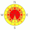
THREAT #1 |

|
| WHERE |
PROBABILITY |
SIZE |
TREND |
|
|
|
|
| |
|
|
Over the next
24 hours.
|
|
|
Winds raged out of the west and northwest yesterday, switching more westerly overnight, transporting an amazing amount of snow onto leeward slopes, not only up high in the wind zone, but well down into mid and low elevation terrain as well. Throughout the storm cycle we've had winds out of the south, southeast, southwest, northwest and west. Almost all aspects are wind loaded now. There are no "safe aspects" at the moment. Avalanches triggered in the newly formed wind drifts can break into weaker layers of snow producing larger more dangerous avalanches than you might expect. |
|
|
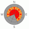
THREAT #2 |

|
| WHERE |
PROBABILITY |
SIZE |
TREND |
|
|
|
|
| |
|
|
Over the next
24 hours.
|
|
|
We've been specifically hunting for weak snow on the southern half of the range to see how it would react to all the added weight of the storm. Ted's been doing the same on the North Slope. (Click here for a brief snowpack tutorial). Our suspicions were confirmed with big red flag warning signs like shooting cracks and booming collapses. As a matter of fact, Grant and I were able to collapse a low angle, 30 degree slope from quite a distance, initiating cracks up to 200’ away. The immediate culprit is the weak near surface facets formed during the December dry spell and our snowpit stability tests reveal this persistent buried weak layer as well. These sugary crystals are buried and preserved in the mid portion of our snowpack and life has been good without any additional weight bearing down on top of them. Essentially they’ve been partying for nearly a month with no worries at all. Now it’s hangover time and they’re reeling from the effects of a heavy dose of fresh snow and strong winds. Many steep slopes throughout the range hang in the balance, just waiting for a rider to come along and reawaken this weak layer. These are exactly the type of snowpack conditions that lead to most fatal avalanche accidents in the western Uinta Mountains. There’s no reason to pull on the dogs tail and second guess the snow stability pattern today. We have a dangerous snowpack and avalanches triggered today can break into weak snow near the ground, resulting in a deep and unsurvivable slide. |
|
|
MOUNTAIN WEATHER |

|
A weak storm system brushing to the north will bring mostly cloudy skies with the chance of a flurry or two. Highs reach into the low and mid 20's. West winds should remain in the 15-35 mph range, relaxing somewhat later in the day. A splitting storm system moves through the region Tuesday and Wednesday for a quick shot of snow. High pressure builds for the latter half of the week. |
|
|
GENERAL ANNOUNCEMENTS |
The information in this advisory expires 24 hours after the date and time posted, but will be updated by 7:00 AM Wednesday January 27th, 2010.
If you’re getting out and about and trigger an avalanche or see anything interesting please drop us an email at craig@utahavalanchecenter.org or call 801-231-2170 |
|
|
This information does not apply to developed ski areas or highways where avalanche control is normally done. This advisory is from the U.S.D.A. Forest Service, which is solely responsible for its content. This advisory describes general avalanche conditions and local variations always occur. |
|
This advisory provided by the USDA Forest Service, in partnership with:
The Friends of the Utah Avalanche Center, Utah Division of State Parks and Recreation, Utah Division of Emergency Management, Salt Lake County, Salt Lake Unified Fire Authority and the friends of the La Sal Avalanche Center. See our Sponsors Page for a complete list. |
