AVALANCHE WARNING »
Dangerous avalanche conditions are occuring or are imminent.
Backcountry travel in avalanche terrain is not recommended.
|
 |
Notice: We’ve issued an AVALANCHE WARNING for all the mountains of Utah. Strong winds and heavy snow have created a HIGH AVALANCHE DANGER on all aspects. Both natural and easily human triggered avalanches are occurring at low, mid & high elevations. People should avoid travel on and below all steep backcountry slopes. BACKCOUNTRY TRAVEL IS NOT RECOMMENDED. |
|
|
BOTTOM LINE
Danger by aspect and elevation on slopes approaching 35° or steeper.
(click HERE for tomorrow's danger rating)
|
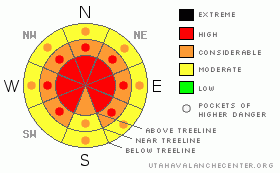
Danger Rose Tutorial
|
At mid and upper elevations the avalanche danger is HIGH (Level 4). Both natural and human triggered avalanches are probable. Avalanches triggered today will be large, dangerous and likely un-survivable. A CONSIDERABLE (Level 3) avalanche danger exists on steep mid & low elevation slopes with recent deposits of wind drifted snow.
|
|
|
CURRENT CONDITIONS |

|
This week’s series of storms transformed our snowpack from a threadbare sheet to a down comforter fit for a king. We have received yet another 12" of snow in the last 24 hours. Winds continue to rage at high elevations, blowing steady out of the W - NW at 45 mph, gusting to 65 mph. Temperatures are hovering around 13 F throughout the range. |
|
|
RECENT ACTIVITY |

|
Friday, one large, bone snapping natural avalanche was reported from upper Weber Canyon occurring on a steep, wind loaded northeast facing slope. The slide was 3’-5’ deep, 250’-300’ wide and failed on weak snow near the ground pulling out the entire season’s snowpack.
We received a second hand report of a few snowmobilers triggering an avalanche in the tower mountain area yesterday. More details would be much appreciated.
Large collapsing or "whoomphing" continues to be the norm throughout the range.
In addition, several smaller natural slides were also reported yesterday, most of them 1’-2’ feet deep and running within the new storm snow.
Click here for recent observations. |
|
|
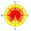
THREAT #1 |

|
| WHERE |
PROBABILITY |
SIZE |
TREND |
|
|
|
|
| |
|
|
Over the next
24 hours.
|
|
|
Winds raged out of the west - northwest overnight & transported an amazing amount of snow onto leeward terrain, not only up high in the wind zone, but well down into mid and low elevation terrain as well. Over the past few days we've had winds out of the southeast, southwest & northwest. Almost all aspects are wind loaded now. There are no "safe aspects" at the moment. Avalanches triggered in the newly formed wind drifts can break into weaker layers of snow producing larger more dangerous avalanches than you might expect.
|
|
|
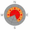
THREAT #2 |

|
| WHERE |
PROBABILITY |
SIZE |
TREND |
|
|
|
|
| |
|
|
Over the next
24 hours.
|
|
|
On Friday, Craig and I specifically went hunting for weak snow on the southern half of the range to see how it would react to all the added weight of the storm. Ted did the same on the North Slope. (Click here for a brief snowpack tutorial). Our suspicions were confirmed with big red flag warning signs like shooting cracks and booming collapses. As a matter of fact, Craig and I were able to collapse a low angle, 30 degree slope from quite a distance, initiating cracks up to 200’ away. The immediate culprit is the weak near surface facets formed during the December dry spell and our snowpit stability tests reveal this persistent buried weak layer as well. These sugary crystals are buried and preserved in the mid portion of our snowpack and life has been good without any additional weight bearing down on top of them. Essentially they’ve been partying for nearly a month with no worries at all. Now it’s hangover time and they’re reeling from the effects of a heavy dose of fresh snow and strong winds. Many steep slopes throughout the range hang in the balance, just waiting for a rider to come along and reawaken this weak layer. These are exactly the type of snowpack conditions that lead to most fatal avalanche accidents in the western Uinta Mountains. There’s no reason to pull on the dogs tail and second guess the snow stability pattern today. We have a dangerous snowpack and avalanches triggered today can break into weak snow near the ground, resulting in a deep and unsurvivable slide. |
|
|
MOUNTAIN WEATHER |

|
Whew, this storm has been a wild ride but, like all good things, it must come to an end. We'll see scattered snow showers phase out this morning as the air mass packs it's bags and leaves town. We'll have a brief respite Monday before a splitting storm rolls in Tuesday morning. Weather models suggest that this storm will do little more for Northern Utah than overcast skies. High pressure builds back in Thursday before another splitter comes off the coast Friday. In short, we seam to have entered a more typical Utah winter weather pattern.
|
|
|
GENERAL ANNOUNCEMENTS |
The information in this advisory expires 24 hours after the date and time posted, but will be updated by 7:00 AM Wednesday January 27th, 2010.
If you’re getting out and about and trigger an avalanche or see anything interesting please drop us an email at craig@utahavalanchecenter.org or call 801-231-2170 |
|
|
This information does not apply to developed ski areas or highways where avalanche control is normally done. This advisory is from the U.S.D.A. Forest Service, which is solely responsible for its content. This advisory describes general avalanche conditions and local variations always occur. |
|
This advisory provided by the USDA Forest Service, in partnership with:
The Friends of the Utah Avalanche Center, Utah Division of State Parks and Recreation, Utah Division of Emergency Management, Salt Lake County, Salt Lake Unified Fire Authority and the friends of the La Sal Avalanche Center. See our Sponsors Page for a complete list. |
