AVALANCHE WARNING »
Dangerous avalanche conditions are occuring or are imminent.
Backcountry travel in avalanche terrain is not recommended.
|
 |
Notice: AN AVALANCHE WARNING IS IN EFFECT FOR ALL THE MOUNTAINS IN UTAH.CONTINUED STRONG WINDS AND HEAVY SNOW HAVE CREATED A HIGHAVALANCHE DANGER FOR ALL THE MOUNTAINS OF UTAH. BACKCOUNTRYTRAVELERS SHOULD AVOID ALL AVALANCHE TERRAIN, ESPECIALLY STEEP SLOPES WITHRECENT DEPOSITS OF WIND DRIFTED SNOW. |
|
|
BOTTOM LINE
Danger by aspect and elevation on slopes approaching 35° or steeper.
(click HERE for tomorrow's danger rating)
|
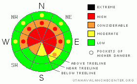
Danger Rose Tutorial
|
At mid and upper elevations the avalanche danger is HIGH (Level 4). Both natural and human triggered avalanches are probable. Avalanches triggered today will be large, dangerous and possibly unsurvivable. Slopes that face the wind and see more sun have a MODERATE danger. Low elevation slopes generally have a LOW danger, as there just isn't much snow down low.
|
|
|
CURRENT CONDITIONS |

|
Several feet of new snow stacked up this week, but the bigger news is the wind. Overnight, south, southwest and southeast winds averaged in the 30’s and 40’s, gusting to 70 mph along the high exposed peaks. Current temperatures are in the mid 20’s at the trailheads and upper teens at 10,000’.
|
|
|
RECENT ACTIVITY |

|
Visibility has been limited and no new avalanches have been reported. |
|
|
THREAT #1 |

|
| WHERE |
PROBABILITY |
SIZE |
TREND |

|
|
|
|
| |
|
|
Over the next
24 hours.
|
|
|
Very strong winds the past 12 hours coupled with an abundance of new storm snow, teamed up to create deep wind drifts along the leeward side of mid and upper elevation terrain, especially on slopes facing the north half of the compass. Some of our shady slopes likely released naturally overnight. Those that didn't won't need much convincing to do the same.
Avalanches triggered within the newly formed wind drifted snow will be large and dangerous and have the potential to break into weak layers of snow near the ground. Avoid slopes that show signs of wind loading- those that appear fat, smooth, rounded & pillow like. |
|
|
THREAT #2 |

|
| WHERE |
PROBABILITY |
SIZE |
TREND |

|
|
|
|
| |
|
|
Over the next
24 hours.
|
|
|
This week’s series of storms have overloaded a very weak and complex snowpack. Today’s avalanches can easily break into the weak, sugary snow near the ground. Once triggered, these slides have the potential to be large, dangerous and possibly unsurvivable. Today, you need to avoid steep slopes and consider the consequences of your terrain choices. Even if you’re traveling on low angle terrain, think about big slopes above and adjacent to you.
|
|
|
MOUNTAIN WEATHER |

|
A moist and unstable southwest flow today will produce 3”-6” of additional snowfall. Southwesterly winds will crank in the 40’s and 50’s along the ridges. High temperatures remain in the mid to upper 20’s.Snow showers tonight and tomorrow with another 5”-10” expectedbefore we finally dry out late Sunday as high pressure returns to the area.
|
|
|
GENERAL ANNOUNCEMENTS |
The information in this advisory expires 24 hours after the date and time posted, but will be updated by 7:00 AM Saturday January 23rd, 2010.
If you’re getting out and about and trigger an avalanche or see anything interesting please drop us an email at craig@utahavalanchecenter.org or call 801-231-2170 |
|
|
This information does not apply to developed ski areas or highways where avalanche control is normally done. This advisory is from the U.S.D.A. Forest Service, which is solely responsible for its content. This advisory describes general avalanche conditions and local variations always occur. |
|
This advisory provided by the USDA Forest Service, in partnership with:
The Friends of the Utah Avalanche Center, Utah Division of State Parks and Recreation, Utah Division of Emergency Management, Salt Lake County, Salt Lake Unified Fire Authority and the friends of the La Sal Avalanche Center. See our Sponsors Page for a complete list. |
