BOTTOM LINE
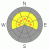
Danger by aspect and elevation on slopes approaching 35° or steeper.
(click HERE for tomorrow's danger rating)
|

Danger Rose Tutorial
|
The avalanche danger is CONSIDERABLE. Fresh wind slabs have developed on lee aspects (Those that face NW, N, NE & E) on both high & mid elevations slopes. Increased load has re-awakened our very weak snow at the ground, and there is potential for large destructive avalanches failing at the ground on those same shady aspects. Slopes that face the wind and see more sun have a MODERATE danger. Low elevation slopes generally have a LOW danger, as there just isn't much snow down low. |
|
|
CURRENT CONDITIONS |

|
Over the past two days we've received a much needed 6" of new snow in the northern part of the range and near a foot of snow in the south. It's not quite enough to cover up the old tracks, but, it certainly helps. The winds have had their way with the new snow, we saw fresh wind slabs approaching 20" in depth yesterday.
Temperatures are around 20 F throughout the range. Winds are steady out of the SE at 20 mph, gusting to 30 mph. |
|
|
RECENT ACTIVITY |

|
Fresh wind slabs were very sensitive yesterday. Light triggers produced slow moving soft slabs that first failed in the new snow, and then stepped down or "gouged" their way into the weaker facets near the ground. These were mostly size 1 soft slab avalanches. While these felt manageable yesterday, continued winds are going to stiffen up the wind slabs which will increase depth and destructive potential. With more snow on the way, you can be sure we will see plenty of natural avalanche activity. |
|
|
THREAT #1 |

|
| WHERE |
PROBABILITY |
SIZE |
TREND |

|
|
|
|
| |
|
|
Over the next
12 hours.
|
|
|
Winds continued to blow above the threshold speed for moving snow last night, and there is plenty of snow available for transport. Wind slabs will be a bit harder to trigger today but they will also be a bit bigger & stiffer. Some of our shady slopes likely released naturally overnight. Those that didn't won't need much convincing to do the same. Avoid slopes that show signs of wind loading, those that appear; fat, smooth, rounded & pillow like. |
|
|
THREAT #2 |

|
| WHERE |
PROBABILITY |
SIZE |
TREND |
|
|
|
|
| |
|
|
Over the next
24 hours.
|
|
|
Yep, it's coming back to life. Yesterday Ted & I saw soft slabs fail first in the new snow, and then step down into the old rotten depth hoar sugar snow near the ground. For the moment, you're going to see this step down occur in area's that had a weak and shallow pack before this last week of storms.
Here's the catch: In deeper locations, say those that had 3' or more before the storm, the pack is going to momentarily hold the new weight. But, we've got more snow on the way, which means more weight on this tired body builder of a snowpack. As we continue to stack weight on the barbells, the pack will eventually give up. Where this magic threshold is, nobody knows, we'll just have to weight and see. But, be aware that the show of strength we're seeing is only temporary. In the southern part of the range where storm totals are higher, the pack will be struggling just to hold up the new load. The weight of a machine, or a rider getting off the machine, could easily be enough to overload the structure, producing potentially large & destructive avalanches failing at the ground. |
|
|
MOUNTAIN WEATHER |

|
We'll see another brief period of snow this morning before things clear up for the afternoon. The next wave of storm is already hitting California, and will pay us a visit this evening. We can expect another 4 - 8 inches of snow tonight before the storm exits east Thursday morning. Friday the jet shifts to a northwesterly flow which will produce for the north slopes, while the rest of the range will largely miss out on the weekend’s storms. |
|
|
GENERAL ANNOUNCEMENTS |
The information in this advisory expires 24 hours after the date and time posted, but will be updated by 7:00 AM Saturday January 23rd, 2010.
If you’re getting out and about and trigger an avalanche or see anything interesting please drop us an email at craig@utahavalanchecenter.org or call 801-231-2170 |
|
|
This information does not apply to developed ski areas or highways where avalanche control is normally done. This advisory is from the U.S.D.A. Forest Service, which is solely responsible for its content. This advisory describes general avalanche conditions and local variations always occur. |
|
This advisory provided by the USDA Forest Service, in partnership with:
The Friends of the Utah Avalanche Center, Utah Division of State Parks and Recreation, Utah Division of Emergency Management, Salt Lake County, Salt Lake Unified Fire Authority and the friends of the La Sal Avalanche Center. See our Sponsors Page for a complete list. |
