BOTTOM LINE
Danger by aspect and elevation on slopes approaching 35° or steeper.
(click HERE for tomorrow's danger rating)
|
Danger Rose Tutorial
|
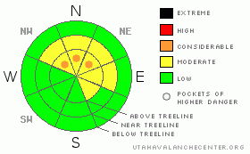
The avalanche danger is MODERATE with pockets of CONSIDERABLE on upper elevation lee aspects. Sensitive wind slabs will begin to develop today on NW, N, NE & E facing slopes.
The avalanche danger remains MODERATE with regard to avalanches breaking into weak snow near the ground. Be weary of mid and upper elevation terrain facing the north half of the compass. While human triggered slides that break into weak snow near the ground are getting harder to initiate, they're still possible, particularly on steep rocky slopes with a shallow weak snowpack.
Be alert for changing conditions and remember; increasing snow and wind mean an increasing avalanche danger. |
|
|
CURRENT CONDITIONS |

|
Our structurally challenged snowpack begins an arduous test as a series of storms enter Utah airspace. This mornings storm will produce only scattered snow showers while this evenings storm will pump out a few inches of snow before moving east. But, this is a sign of things to come later in the week.
Temperatures are very mild this morning, just a few degrees below freezing in most locations while upper elevation winds are raging. Winds are steady out of the South at 30 mph, gusting to over 50 mph. |
|
|
RECENT ACTIVITY |

|
No new avalanche activity to report.
Recent Uinta observations can be found here. |
|
|
THREAT #1 |

|
| WHERE |
PROBABILITY |
SIZE |
TREND |

|
|
|
|
| |
|
|
Over the next
24 hours.
|
|
|
The winds are looking to take any loose snow for a wild ride at the moment. While loose snow has been at a premium, it's all about to change. The big winds will quickly form the new snow into sensitive wind slabs. This hazard should be manageable for the daylight hours today. Slope cuts are a great tool to use when dealing with this avalanche dragon. Take head though, more snow and increased winds this evening could quickly move these wind slabs to the unmanageable category. Wind can move snow at 10x the rate it falls out of the sky. Even a few inches of snow could mean two foot wind slabs on our lee aspects this time tomorrow. |
|
|
THREAT #2 |

|
| WHERE |
PROBABILITY |
SIZE |
TREND |

|
|
|
|
| |
|
|
Over the next
24 hours.
|
|
|
Our snowpack is on trial this week. The suspect is weak, jittery and ready to collapse under the slightest amount of pressure. In short, it doesn't look good. The sugar snow near the ground has been dormant only because there has not been enough weight to overload it. Today's storm won't be enough to bring the facets into the fight, but, they will re-activate as we continue to put additional load on them this week.
Today, the deep avalanche will still be pockety in nature, relegated to steep, rocky upper elevation terrain where the snowpack is shallow and weak. |
|
|
MOUNTAIN WEATHER |

|
Utah will be affected by a moist west - southwest flow this week as a series of increasingly vigorous storms move across the forecast area. Today, the first storm will move through the Western Uintas bringing scattered snow showers ending near noon. A stronger system moves in this evening which will result in snowfall through early Tuesday.
Here in the northern mountains we'll see a bit of a break in the action before the most robust part of the system moves in Thursday. Total precip amounts are hard to pin down at the moment, but, we should see continued snowfall before high pressure moves back into the picture Sunday. |
|
|
GENERAL ANNOUNCEMENTS |
The information in this advisory expires 24 hours after the date and time posted, but will be updated by 7:00 AM Wednesday January 20th, 2010.
If you’re getting out and about and trigger an avalanche or see anything interesting please drop us an email at craig@utahavalanchecenter.org or call 801-231-2170 |
|
|
This information does not apply to developed ski areas or highways where avalanche control is normally done. This advisory is from the U.S.D.A. Forest Service, which is solely responsible for its content. This advisory describes general avalanche conditions and local variations always occur. |
|
This advisory provided by the USDA Forest Service, in partnership with:
The Friends of the Utah Avalanche Center, Utah Division of State Parks and Recreation, Utah Division of Emergency Management, Salt Lake County, Salt Lake Unified Fire Authority and the friends of the La Sal Avalanche Center. See our Sponsors Page for a complete list. |
