SPECIAL ANNOUNCEMENT |
 |
We finally got the kinks worked out and four weather stations are up and running in Weber Canyon and along the Mirror Lake Highway. Click here for real-time wind, temperatures and snowfall. |
|
|
BOTTOM LINE
Danger by aspect and elevation on slopes approaching 35° or steeper.
(click HERE for tomorrow's danger rating)
|
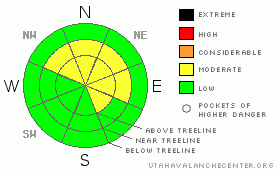
Danger Rose Tutorial
|
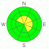
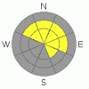
The avalanche danger remains MODERATE in mid and upper elevation terrain facing the north half of the compass and human triggered slides which break into weak snow near the ground are still possible, especially on steep rocky slopes with a shallow weak snowpack.
A MODERATE avalanche danger also exists on upper elevation, leeward slopes with recent deposits of wind drifted snow.
The avalanche danger is generally LOW on sunny slopes and in low elevation terrain. |
|
|
CURRENT CONDITIONS |

|
A couple more days of stagnant weather are on tap before a major pattern shift starts affecting the region. Under partly cloudy skies this morning, temperatures are in the mid 20’s at the trailheads and along the ridges. Northerly winds picked up around 10:00 last night and have been blowing 15-25 mph along the high peaks and exposed ridgelines. No significant new snow has fallen since the New Years Eve storm and upper elevation snow depths are grim at best with only about 3’ total… that’s ½ our average snowpack for this time of year.
|
|
|
RECENT ACTIVITY |

|
No new avalanche activity to report.
Recent Uinta observations can be found here. |
|
|
THREAT #1 |

|
| WHERE |
PROBABILITY |
SIZE |
TREND |
|
|
|
|
| |
|
|
Over the next
24 hours.
|
|
|
Last night’s winds probably created a fresh wind drift or two on the leeward side of upper elevation ridges, but in general these should be easy to detect and mostly manageable in size. However, do take care that one doesn’t catch you off guard, knocking you off your skis, board or sled.
|
|
|
THREAT #2 |

|
| WHERE |
PROBABILITY |
SIZE |
TREND |
|
|
|
|
| |
|
|
Over the next
24 hours.
|
|
|
Right now the snowpack is a lot like me at the end of a busy winter season- tired, lifeless and not full of much energy. Much like me though, the snowpack gets energized and comes back to life once a big storm starts to materialize. Well it looks like winter will finally get going in the next couple of days and it won’t take much of a load before our weak, house of cards snowpack reacts and we see avalanches. Let’s face it; our snowpack has some major issues this winter. It’s unusually weak and shallow for this time of year and as you already know- a weak snowpack is a dangerous snowpack.
Until it starts storming again, the elusive avalanche dragon is in hibernation mode and there are only a few isolated places where you could trigger a deep, scary avalanche today. Of course the usual suspects come to mind- steep, rocky, upper elevation terrain with a shallow, weak snowpack.
|
|
|
MOUNTAIN WEATHER |

|
High pressure remains in place through today, giving us partly cloudy skies and warm temperatures. Highs at 8,000’ will be near 40 degrees and at 10,000’ in the low to mid 30’s. Overnight lows dip into the mid teens. Winds should shift to the southwest and blow in the teens and low 20’s with a few gusts in the 30’s along the high peaks. A weak storm system will move through the area into Sunday and skies will be mostly cloudy. The first in a series of storms begins on Monday, signaling a major weather pattern change for the area with a week-long string of storms expected to impact the region through next weekend. Check out this great weather briefing from the National Weather Service.
|
|
|
GENERAL ANNOUNCEMENTS |
The information in this advisory expires 24 hours after the date and time posted, but will be updated by 7:00 AM Sunday January 17th, 2010.
If you’re getting out and about and trigger an avalanche or see anything interesting please drop us an email at craig@utahavalanchecenter.org or call 801-231-2170
Also, now is a great time to schedule one of our free avalanche awareness presentations for your group or club. Email or call us and we’ll get you booked before things get too crazy. |
|
|
This information does not apply to developed ski areas or highways where avalanche control is normally done. This advisory is from the U.S.D.A. Forest Service, which is solely responsible for its content. This advisory describes general avalanche conditions and local variations always occur. |
|
This advisory provided by the USDA Forest Service, in partnership with:
The Friends of the Utah Avalanche Center, Utah Division of State Parks and Recreation, Utah Division of Emergency Management, Salt Lake County, Salt Lake Unified Fire Authority and the friends of the La Sal Avalanche Center. See our Sponsors Page for a complete list. |
