SPECIAL ANNOUNCEMENT |
 |
We're still waiting for more snow to install Beacon Basin at the Noblett's trailhead, but over at the Bear River trailhead Ted's got a beacon park up and running. |
|
|
BOTTOM LINE
Danger by aspect and elevation on slopes approaching 35° or steeper.
(click HERE for tomorrow's danger rating)
|
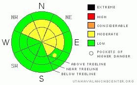
Danger Rose Tutorial
|
The avalanche danger remains MODERATE in mid and upper elevation terrain facing the north half of the compass and human triggered slides which break into weak snow near the ground are still possible, especially on steep rocky slopes with a shallow weak snowpack.
A MODERATE avalanche danger also exists on upper elevation, leeward slopes with recent deposits of wind drifted snow.
The avalanche danger is generally LOW on sunny slopes and in low elevation terrain. |
|
|
CURRENT CONDITIONS |

|
A splitting storm system will affect the state late this afternoon into tonight. Prior to the storms arrival winds began cranking out of the south around 4:00 yesterday afternoon, averaging 35 mph with gusts near 60 mph along the high exposed ridgelines. Overnight, winds became a little better behaved and are currently blowing out of the southwest in the 20-30 mph range. Temperatures are quite mild for January, in the low to mid 20’s. Average total snow depths remain shallow, right around three feet and in many areas the snow is so weak it’s like riding in a sandbox.
|
|
|
RECENT ACTIVITY |

|
No new avalanche activity to report.
Recent Uinta observations can be found here. |
|
|
THREAT #1 |

|
| WHERE |
PROBABILITY |
SIZE |
TREND |
|
|
|
|
| |
|
|
Over the next
24 hours.
|
|
|
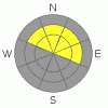
Recent warm temperatures have helped the snowpack gain some strength, but in general the pack remains inherently weak and its structure is rather complex. While I haven’t heard of any recent avalanche activity and it appears that it’s becoming more of a rarity to trigger a slide that breaks into weak layers of snow near the ground, quite frankly I still don’t trust the pack and I’m not about to dive into steep terrain just yet. Remember- the western Uinta’s are a huge range and in dry snow years like this one, the snowpack is incredibly variable. On one slope the pack may be deep and strong while just a hundred feet away it’s shallow and rocky. With that much variability you’re best bet is to continue avoiding terrain where you could trigger a scary avalanche. Steep, upper elevation, rocky slopes with a thin, shallow snowpack remains a likely suspect.
|
|
|
THREAT #2 |

|
| WHERE |
PROBABILITY |
SIZE |
TREND |
|
|
|
|
| |
|
|
Over the next
24 hours.
|
|
|
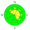
Yesterday’s howling winds probably found enough loose snow to blow around and form shallow, yet stiff and supportable wind slabs along and just down slope of upper elevation ridges. These new wind drifts are resting on top of weak, sugary surface snow and will react to the additional weight of a rider. While manageable in size and easy to detect by their dull appearance and hollow drum like feel, take care that one doesn’t catch you off guard and take you for an unexpected ride.
|
|
|
MOUNTAIN WEATHER |

|
A pacific storm system moving inland splits as it passes through Utah late this afternoon through tonight. Skies will be mostly cloudy today, temperatures will climb into the low to mid 30’s and southwest winds are expected to gust into the upper 30’s along the high ridges. Overnight lows dip into the low 20’s and we should see a couple inches of snow by morning. Mostly cloudy skies and a flurry or two are on tap for Thursday before high pressure returns for Friday into the weekend. A pattern shift comes together for early next week, though at this time it looks like most of the energy dives south of our region.
|
|
|
GENERAL ANNOUNCEMENTS |
The information in this advisory expires 24 hours after the date and time posted, but will be updated by 7:00 AM Saturday January 16th, 2010.
If you’re getting out and about and trigger an avalanche or see anything interesting please drop us an email at craig@utahavalanchecenter.org or call 801-231-2170
Also, now is a great time to schedule one of our free avalanche awareness presentations for your group or club. Email or call us and we’ll get you booked before things get too crazy. |
|
|
This information does not apply to developed ski areas or highways where avalanche control is normally done. This advisory is from the U.S.D.A. Forest Service, which is solely responsible for its content. This advisory describes general avalanche conditions and local variations always occur. |
|
This advisory provided by the USDA Forest Service, in partnership with:
The Friends of the Utah Avalanche Center, Utah Division of State Parks and Recreation, Utah Division of Emergency Management, Salt Lake County, Salt Lake Unified Fire Authority and the friends of the La Sal Avalanche Center. See our Sponsors Page for a complete list. |
