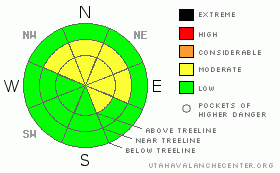
BOTTOM LINE
Danger by aspect and elevation on slopes approaching 35° or steeper.
(click HERE for tomorrow's danger rating)
|

Danger Rose Tutorial
|
The avalanche danger remains MODERATE in mid and upper elevation terrain facing the north half of the compass and human triggered slides which break into weak snow near the ground are still possible, especially on steep rocky slopes with a shallow weak snowpack.
A MODERATE avalanche danger also exists on upper elevation, leeward slopes with recent deposits of wind drifted snow.
The avalanche danger is generally LOW on sunny slopes and in low elevation terrain. |
|
|
CURRENT CONDITIONS |

|
High pressure continues to dominate our weather pattern, producing smoggy haze in the valleys and partly cloudy skies as you gain elevation. Currently, temperatures are in the low 20’s at both the trailheads and along the ridges. Winds picked up early this morning and are blowing 15-20 mph out of the north and northeast. With average snow depths right around three feet, most of our terrain remains thin and rocky. However, soft creamy surface snow can still be found in sheltered shady terrain.
|
|
|
RECENT ACTIVITY |

|
No new avalanche activity to report.
Recent Uinta observations can be found here. |
|
|
THREAT #1 |

|
| WHERE |
PROBABILITY |
SIZE |
TREND |

|
|
|
|
| |
|
|
Over the next
24 hours.
|
|
|
We’ve received no new reports of recent avalanche activity, but yesterday Ted did experience some minor collapsing as he traveled around Gold Hill. In general though, the snowpack seems rather lifeless and lacking much energy. Sure, that may be the case for a large majority of our terrain, but most folks I talk with still have an uneasiness about center punching anything big and gnarly… and rightfully so. Let’s face it, our snowpack has some issues. It remains woefully shallow and the structure is very weak with a cohesionless, sugary base. Not the greatest building blocks for a strong, stable snowpack. As you already know, we trigger deep scary avalanches from thin portions of the snowpack, not where it’s thick and feeling solid. If you’re travels take you into steep, upper elevation terrain facing the north half of the compass today, think not only about the snow you’re riding in, but also the snow you’re riding on. There’s still a isolated possibility of triggering a deeper avalanche which breaks into weak shallow snow near the ground, especially in steep, rocky terrain. |
|
|
THREAT #2 |

|
| WHERE |
PROBABILITY |
SIZE |
TREND |

|
|
|
|
| |
|
|
Over the next
24 hours.
|
|
|
While avalanche conditions seem rather benign right now, be on the lookout for shallow wind drifts along the leeward side of upper elevation ridges which may be sensitive to the weight of a rider. |
|
|
MOUNTAIN WEATHER |

|
A firmly entrenched ridge of high pressure will keep storms at bay for the next couple of days and we can expect partly cloudy skies, warm temperatures and light northwesterly winds. Highs today and tomorrow will reach into the low and mid 40’s at 8,000’ and near freezing at 10,000’. Overnight lows bottom out in the single digits. Winds should remain in the 10-20 mph range. A splitting storm system rolls through the region Tuesday and Wednesday, giving us mostly cloudy skies and light snow showers, but no block buster storm.
|
|
|
GENERAL ANNOUNCEMENTS |
The information in this advisory expires 24 hours after the date and time posted, but will be updated by 7:00 AM Wednesday January 13th, 2010.
If you’re getting out and about and trigger an avalanche or see anything interesting please drop us an email at craig@utahavalanchecenter.org or call 801-231-2170
Also, now is a great time to schedule one of our free avalanche awareness presentations for your group or club. Email or call us and we’ll get you booked before things get too crazy. |
|
|
This information does not apply to developed ski areas or highways where avalanche control is normally done. This advisory is from the U.S.D.A. Forest Service, which is solely responsible for its content. This advisory describes general avalanche conditions and local variations always occur. |
|
This advisory provided by the USDA Forest Service, in partnership with:
The Friends of the Utah Avalanche Center, Utah Division of State Parks and Recreation, Utah Division of Emergency Management, Salt Lake County, Salt Lake Unified Fire Authority and the friends of the La Sal Avalanche Center. See our Sponsors Page for a complete list. |


