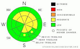
BOTTOM LINE
Danger by aspect and elevation on slopes approaching 35° or steeper.
(click HERE for tomorrow's danger rating)
|
Danger Rose Tutorial
|
A MODERATE hazard is in place for dangerous persistent slabs that exist on high and mid elevation aspects that see the most shade during the day. (NW, N, NE & E) The slab is especially sensitive in areas of shallow snow depth that have not yet slid. Assess each slope thoroughly before committing to ride.
Moderate winds and continued light snowfall have made for a MODERATE wind slab hazard. Be on the lookout for shallow manageable wind slabs on lee aspects. |
|
|
CURRENT CONDITIONS |

|
Shallow, thin, slight, whatever you want to call it. The shallower it is, the weaker it is & low snow depths are the constant across the range. The grass is poking up in lots of places still, the rocks aren't totally buried and the entire snowpack can feel the weight of a rider most anywhere in the range.
Recent Uinta observations can be found here. |
|
|
RECENT ACTIVITY |

|
Some rather scary collapsing was reported from the east side of the range over the weekend. But no natural or human triggered avalanche activity has been reported or observed. |
|
|
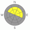
THREAT #1 |

|
| WHERE |
PROBABILITY |
SIZE |
TREND |
|
|
|
|
| |
|
|
Over the next
24
hours.
|
|
|
There's the famous Dutch fairy tale of the princess and the pea. In summary, true royalty were very sensitive to imperfections, and a real princess could feel a pea despite 20 mattresses on top of it. Snow depths are fattest in the central part of the range, stretching towards 48" in wind favored locales. In these kinds of places the facets at the ground are not reactive to the weight of a rider nor testing. The thicker mattress of snow is insulating the weaknesses from force.
This all changes in places where the snowpack is thin. A great observation came in from a snow professional who was "relaxing" at the Boundary creek yurt near Evanston. Over yonder, snow depths are a measly 24" even above 10,000 feet. His experience was hair raising, full of wide spread cracking and collapsing. Here, the facets were overloaded by the weight of a human and the entire snowpack was failing.
So the writing is on the wall. Anywhere it's thin, human triggered avalanches are possible. Avoid steep, shady high elevation terrain and you can likely avoid big slab avalanches. Tweak small test slopes before committing to the bigger stuff and keep your wits about you. Don't let the shallow pack lure you into complacency. Remember that snow, like royalty, does not always behave in a way we can make sense of. Pockets of instability exist even in areas of an otherwise fat snowpack. |
|
|
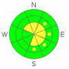
THREAT #2 |

|
| WHERE |
PROBABILITY |
SIZE |
TREND |
|
|
|
|
| |
|
|
Over the next
24
hours.
|
|
|
We'll see another inch or two of new snow come down today with moderate winds out of the NW. Watch for small, manageable wind slab avalanches on lee aspects. Should be a very manageable hazard, but still something to be on the lookout for. |
|
|
MOUNTAIN WEATHER |

|
Warm temperatures this morning. Temps just below freezing are the norm throughout the range. Blowing snow will continue throughout the day before being replaced by a brisk arctic cold front this evening. Best to plug in the diesel tonight. Our weekend will be composed of high pressure and sunny skies. The ridge continues to strengthen next week with no new snow in the foreseeable future. |
|
|
GENERAL ANNOUNCEMENTS |
The information in this advisory expires 24 hours after the date and time posted, but will be updated by 7:00 AM Saturday January 9th, 2010.
If you’re getting out and about and trigger an avalanche or see anything interesting please drop us an email at craig@utahavalanchecenter.org or call 801-231-2170
Also, now is a great time to schedule one of our free avalanche awareness presentations for your group or club. Email or call us and we’ll get you booked before things get too crazy. |
|
|
This information does not apply to developed ski areas or highways where avalanche control is normally done. This advisory is from the U.S.D.A. Forest Service, which is solely responsible for its content. This advisory describes general avalanche conditions and local variations always occur. |
|
This advisory provided by the USDA Forest Service, in partnership with:
The Friends of the Utah Avalanche Center, Utah Division of State Parks and Recreation, Utah Division of Emergency Management, Salt Lake County, Salt Lake Unified Fire Authority and the friends of the La Sal Avalanche Center. See our Sponsors Page for a complete list. |
