BOTTOM LINE
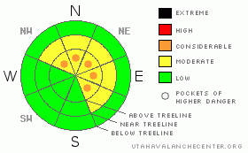
Danger by aspect and elevation on slopes approaching 35° or steeper.
(click HERE for tomorrow's danger rating)
|

Danger Rose Tutorial
|
At mid and upper elevations the avalanche danger is MODERATE today and human triggered avalanches are possible on steep, wind drifted slopes. In the wind zone above treeline, pockets of CONSIDERABLE avalanche danger exist, especially on slopes with an easterly component to their aspect and human triggered avalanches are likely.
A MODERATE avalanche danger still exists for scarier avalanches, which break into deeper buried weak layers of snow near the ground. Dangerous, human triggered avalanches are possible today, especially in steep, rocky, upper elevation terrain that faces the north half of the compass with a shallow weak snowpack.
Out of the wind and at low elevations the avalanche danger is generally LOW. |
|
|
CURRENT CONDITIONS |

|
Light snow is just starting to fall as a fast moving storm system noses into northern Utah this morning. Skies are cloudy, west and southwest winds are blowing 25 mph with gusts in the upper 50’s along the high ridges and temperatures in the mid to upper 20’s are gonna seem balmy. Riding and turning conditions are slowly improving, but with total snow depths averaging right around 3’ at the upper elevations, it’s still relatively thin out there. |
|
|
RECENT ACTIVITY |

|
No new avalanche activity to report.
Click here for links to real time winds and snowfall amounts. |
|
|
THREAT #1 |

|
| WHERE |
PROBABILITY |
SIZE |
TREND |

|
|
|
|
| |
|
|
Over the next
24 hours.
|
|
|
Yesterday’s damp, humid atmosphere capped the snow surface with a thin crust and the wind had a hard time transporting any significant amounts of snow. In other words, I blew the forecast and slabs were better behaved than I expected. However, winds this morning seem burly enough to whip the dense surface snow into a fresh batch of wind slabs and that’ll be today’s most obvious avalanche concern. Fresh wind drifts will be forming on the leeward side of ridges and around terrain features like gullies and chutes. I think these will be mostly manageable in size, but given the weak state of our snowpack, even a small avalanche can break into deeper buried weak layers, creating a larger slide than you’d expect. Today you’ll want to gather some information before committing to big terrain. Tweak small test slopes with little or no consequence and see what kind of avalanche dragon you’re dealing with. |
|
|
THREAT #2 |

|
| WHERE |
PROBABILITY |
SIZE |
TREND |

|
|
|
|
| |
|
|
Over the next
24 hours.
|
|
|
Ted and I went hunting for faceted, sugary snow yesterday to see what it’s going to take to trigger a slide that breaks into the rotten snow near the ground. In general we found very weak snow, especially in steep, rocky, upper elevation terrain facing the north half of the compass (click here for a pit profile). While it'll come back to haunt us once it starts snowing again, the good news in the short term is- what little structure the mid portion of our snowpack once had has deteriorated over time and in many places the pack is losing some of its slab-like cohesive properties and becoming a bottomless facet factory. The bad news is we can’t see all the snow throughout the range and there’s plenty of slopes that have some strength or “body” left in the snowpack and these would be the types of places where you could still trigger a deep, dangerous avalanche. While pockety in nature and becoming harder to trigger, the consequences of misjudging this type of avalanche condition still remain quite serious. Unless you’ve got a good handle on the snowpack and its stability, you’re best bet is to continue avoiding steep, shady, upper elevation terrain. |
|
|
MOUNTAIN WEATHER |

|
We should see snow showers today with accumulations in the 2”-4” range. Westerly winds will be a problem this morning, averaging in the 20’s with gusts in the 40’s and 50’s along the high ridges. Winds should veer to the northwest and decrease late this afternoon. High temperatures today reach into the low 30’s at 8,000’ and mid 20’s at 10,000’. Under clearing skies, overnight lows dip into the single digits. Partly cloudy skies and cool temperatures are on tap for Sunday into the early portion of next week. There are no big storms in sight. |
|
|
GENERAL ANNOUNCEMENTS |
The information in this advisory expires 24 hours after the date and time posted, but will be updated by 7:00 AM on Sunday January 3, 2010.
If you’re getting out and about and trigger an avalanche or see anything interesting please drop me an email at craig@utahavalanchecenter.org or call 801-231-2170
Also, now is a great time to schedule one of our free avalanche awareness presentations for your group or club. Email or call me and we’ll get you booked before things get too crazy. |
|
|
This information does not apply to developed ski areas or highways where avalanche control is normally done. This advisory is from the U.S.D.A. Forest Service, which is solely responsible for its content. This advisory describes general avalanche conditions and local variations always occur. |
|
This advisory provided by the USDA Forest Service, in partnership with:
The Friends of the Utah Avalanche Center, Utah Division of State Parks and Recreation, Utah Division of Emergency Management, Salt Lake County, Salt Lake Unified Fire Authority and the friends of the La Sal Avalanche Center. See our Sponsors Page for a complete list. |

