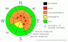
BOTTOM LINE
Danger by aspect and elevation on slopes approaching 35° or steeper.
(click HERE for tomorrow's danger rating)
|
Danger Rose Tutorial
|
In the wind zone at mid and upper elevations the avalanche danger is CONSIDERABLE today and human triggered avalanches are likely, especially in steep, wind loaded terrain. With strong winds on tap, the avalanche danger may rise to HIGH in the wind zone as the day wares on.
A MODERATE avalanche danger still exists for scarier avalanches, which break into deeper buried weak layers of snow near the ground. Dangerous, human triggered avalanches are possible today, especially in steep, rocky, upper elevation terrain that faces the north half of the compass with a shallow weak snowpack.
Out of the wind at low elevations the avalanche danger is generally LOW.
|
|
|
CURRENT CONDITIONS |

|
Temperatures, clouds and wind have all been on the increase overnight, ahead of a moist Pacific storm slated to affect the region today through Saturday. Winds switched to the southwest around 7:00 last night, blowing 25-35 mph with gusts near 50 along the high ridges and exposed peaks. In the past few hours they’ve relaxed into the 15-30 mph range. Currently, temperatures are in the mid 20’s at the trailheads and upper teens at 10,000’. Total snow depths average just about three feet at the upper elevations.
|
|
|
RECENT ACTIVITY |

|
Yesterday, several avalanches were reported in steep upper elevation terrain. Averaging 10”-12” in depth, all the activity involved the new storm snow only. Check out Ted’s awesome observations from yesterday here.
|
|
|
THREAT #1 |

|
| WHERE |
PROBABILITY |
SIZE |
TREND |
|
|
|
|
| |
|
|
Over the next
24 hours.
|
|
|
We’ll see a day of changing avalanche conditions and it’s time to start thinking about not only the snow we’re riding in, but also the snow we’re riding on. Recrystallized surface snow got buried by the mid week storm and that weakness is preserved and hasn’t gained any strength in the short term. Then overnight, strong winds changed the avalanche equation and yesterday’s light fluffy in your face powder is becoming dense and slabby. Now a cohesive piece of snow, a slab, rests on top of weak snow and along with several bed surfaces for avalanches to run on, all the ingredients for a slab avalanche are coming together. As winds continue to blow and new snow starts to stack up, slabs will break deeper and wider than you might expect and have the potential to break into deeper buried weak layers as they descend the slope, creating an unmanageable avalanche. Today you’ll need to carefully evaluate your terrain choices and avoid steep slopes with recent deposits of wind drifted snow.
|
|
|
THREAT #2 |

|
| WHERE |
PROBABILITY |
SIZE |
TREND |

|
|
|
|
| |
|
|
Over the next
24 hours.
|
|
|
This weekends storm may insult our problem child- the weak, rotten snow near the ground- helping to overload this temperamental persistent instability. Recent snowpit stabiity tests indicate it’s getting harder to trigger a slide that breaks into weak snow near the ground, especially where the snowpack is thick and relatively strong. However, we tend to trigger deep dangerous slides in areas with weak shallow snow and it takes a lot of detective work to figure out an overall snowpack stability trend. In addition, if you haven’t done your homework and happen to misjudge our structurally challenged snowpack, it isn’t very forgiving and the consequences of making a mistake are severe. Steep, rocky upper elevation terrain remains a likely suspect where you’ll encounter this unmanageable avalanche condition. |
|
|
MOUNTAIN WEATHER |

|
This morning should be cloudy and light snow showers are expected before the main event arrives later tonight into Saturday. Temperatures will seem relatively mild with highs at 8,000’ in the mid 30’s and at 10,000’ in the upper 20’s. Overnight lows dip into the mid 20’s. West and southwest winds will be an issue today, blowing in the 30’s and 40’s along the ridges with gusts in the 50’s near the high peaks. The upcoming storm looks like it’ll go north of our region, but we should still see a light shot of snow developing late tonight and storm totals should be in the 4”-6” range. Lingering snow showers for Saturday, then high pressure builds for the later half of the weekend through early next week.
|
|
|
GENERAL ANNOUNCEMENTS |
The information in this advisory expires 24 hours after the date and time posted. I will update this advisory by 7:00 AM on Saturday January 2, 2010.
If you’re getting out and about and trigger an avalanche or see anything interesting please drop me an email at craig@utahavalanchecenter.org or call 801-231-2170
Also, now is a great time to schedule one of our free avalanche awareness presentations for your group or club. Email or call me and we’ll get you booked before things get too crazy. |
|
|
This information does not apply to developed ski areas or highways where avalanche control is normally done. This advisory is from the U.S.D.A. Forest Service, which is solely responsible for its content. This advisory describes general avalanche conditions and local variations always occur. |
|
This advisory provided by the USDA Forest Service, in partnership with:
The Friends of the Utah Avalanche Center, Utah Division of State Parks and Recreation, Utah Division of Emergency Management, Salt Lake County, Salt Lake Unified Fire Authority and the friends of the La Sal Avalanche Center. See our Sponsors Page for a complete list. |
