SPECIAL ANNOUNCEMENT |
 |
Merry Christmas! We recently installed three weather stations which are up and running in Weber Canyon and along the Mirror Lake Highway. A fourth will be online soon. Click here for current winds, temperatures and snow accumulations.
|
|
|
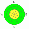
BOTTOM LINE
Danger by aspect and elevation on slopes approaching 35° or steeper.
(click HERE for tomorrow's danger rating)
|

Danger Rose Tutorial
|
The avalanche danger is MODERATE on steep wind drifted slopes at both mid and upper elevations and human triggered avalanches are possible. Be aware that within this elevation band pockets of CONSIDERABLE avalanche danger exist, especially on slopes that had a pre-existing snowpack prior to the mid December storm. Dangerous avalanches can still be triggered on upper elevation slopes that face northwest, north, northeast and east. Avalanches triggered in this type of terrain will be large and unmanageable, pulling out much wider and deeper than you might expect.
A LOW avalanche danger exists on most sun-exposed slopes and low elevation terrain. |
|
|
CURRENT CONDITIONS |

|
A cold northerly flow developed overnight, ushering in an inch of snow and finger numbing temperatures. Currently, it’s 9 degrees at the trailheads and 2 degrees at 10,000’. North and northwest winds are blowing 15-25 mph, gusting into the mid 30’s along the high peaks, producing a wind chill of -20 degrees. Riding conditions are improving, but with only 3’ of total snow depth in most locations it’s still pretty boney out there.
|
|
|
RECENT ACTIVITY |

|
No recent avalanche activity to report. Click here for recent snowpack observations.
|
|
|
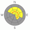
THREAT #1 |

|
| WHERE |
PROBABILITY |
SIZE |
TREND |
|
|
|
|
| |
|
|
Over the next
24 hours.
|
|
|
North and northwest winds have been busy at work the past two days, creating wind slabs on upper elevation leeward slopes. Though not widespread and pockety in nature, they’re sensitive to the weight of a rider and big enough to knock you off your sled, skis or board and take you for a ride. Be aware that even a small wind drift may break into weaker snow as it descends the slope, triggering a much bigger slide than you bargained for. Today you’ll want to continue avoiding these hollow sounding hard slabs which look like fat rounded pillows of snow.
|
|
|
THREAT #2 |

|
| WHERE |
PROBABILITY |
SIZE |
TREND |
|
|
|
|
| |
|
|
Over the next
24 hours.
|
|
|
The bigger avalanche concern is triggering a deeper slide which breaks into old snow near the ground, especially in terrain that didn’t slide during the mid December avalanche cycle. Snowpit stability tests indicate the snowpack is slowly healing, but remains quite reactive, especially in upper elevation terrain that had pre-exiting snow prior to the big mid December storm. We continue to see failures on weak sugary snow near the ground and avalanche conditions remain deceptively tricky. As a matter of fact, you can ride plenty of steep slopes without incident, particularly if they’ve already avalanched this season. However, if you’re getting into steep, rocky, upper elevation terrain and haven’t been tracking the history of the slope it’s still a bit of a crap shoot. If your travels take you into this type of terrain you’ll need to carefully evaluate the snowpack, your terrain choices and above all, think about the consequences of triggering a slide.
|
|
|
MOUNTAIN WEATHER |

|
The area remains under a northwest flow today, giving us cold temperatures, strong ridgeline winds and a flurry or two through tonight. Highs at 8,000’ only reach into the mid teens, at 10,000’ near 10 degrees. Under clearing skies overnight lows will be right around -5 degrees. North and northwest winds will gust into the 40’s along the high peaks. High pressure and continued cold temperatures are on tap for the weekend.
|
|
|
GENERAL ANNOUNCEMENTS |
The information in this advisory expires 24 hours after the date and time posted. I will update this forecast by 7:00 AM Saturday December 26th.
If you’re getting out and about and trigger an avalanche or see anything interesting please drop me an email at craig@utahavalanchecenter.org or call 801-231-2170
Also, now is a great time to schedule one of our free avalanche awareness presentations for your group or club. Email or call me and we’ll get you booked before things get too crazy. |
|
|
This information does not apply to developed ski areas or highways where avalanche control is normally done. This advisory is from the U.S.D.A. Forest Service, which is solely responsible for its content. This advisory describes general avalanche conditions and local variations always occur. |
|
This advisory provided by the USDA Forest Service, in partnership with:
The Friends of the Utah Avalanche Center, Utah Division of State Parks and Recreation, Utah Division of Emergency Management, Salt Lake County, Salt Lake Unified Fire Authority and the friends of the La Sal Avalanche Center. See our Sponsors Page for a complete list. |
