BOTTOM LINE
Danger by aspect and elevation on slopes approaching 35° or steeper.
(click HERE for tomorrow's danger rating)
|
Danger Rose Tutorial
|
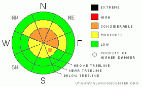
The avalanche danger remains CONSIDERABLE and human triggered avalanches are likely on steep slopes above about 9,300’, especially those that had a pre-existing snowpack prior to last weekend’s storm that face northwest, north, northeast and east. Avalanches triggered in this type of terrain will be large and dangerous, pulling out much wider and deeper than you might expect.
At mid elevations a MODERATE avalanche danger exists in steep terrain facing the north half of the compass and human triggered avalanches are possible.
A LOW avalanche danger exists on most sun-exposed slopes and low elevation terrain.
|
|
|
CURRENT CONDITIONS |

|
High pressure over the region is giving us partly cloudy skies this morning with temperatures in the low to mid 20’s. Westerly winds are blowing 5-15 mph along the ridges, gusting near 25 mph along the high peaks. No new to snow to report in the past 24 hours and our average snow depths hover right around three feet. The snowpack is becoming more supportable, but in most areas remains bottomless, making for difficult travel.
|
|
|
RECENT ACTIVITY |

|
No new avalanche activity that we know of. On Friday, Ted took a look at a snowmobile triggered slide on Double Hill which appeared to be initiated sometime Thursday. The avalanche was over 3’ deep, 300' wide, running over 400 vertical feet, failing on weak sugary snow near the ground. In other words… it ran to the dirt. Fortunately, it appears the rider came out unscathed.
Click here to view avalanche observations from Upper Weber Canyon. |
|
|
THREAT #1 |

|
| WHERE |
PROBABILITY |
SIZE |
TREND |

|
|
|
|
| |
|
|
Over the next
24 hours.
|
|
|
Recent warm temperatures are helping the snowpack gain a little strength, but like most early season shallow snowpacks, our weak house of cards remains inherently dangerous. As the surface snow becomes more supportable it’ll give us a false sense of security, feeling solid under our sled, skis or board and therein lies the problem. Remember- much of our upper elevation north facing terrain had old October snow which grew very weak and sugary during the long dry spell prior to last weekend’s big storm. And then, dense heavy storm snow fell like a cast iron skillet onto a weak, potato chip-like base and the fragile sugary facets near the ground are still having a hard time adjusting. Now we have strong snow on weak snow and that’s a dangerous combination. While much of the steeper terrain slid naturally, many slopes hang in the balance waiting for a trigger like us to come along.
Avalanche conditions remain deceptively tricky and you can still trigger deep, dangerous slides that run to the ground. In addition to the technical aspects of the snowpack, we’ve got the perfect “human factor” setup for an avalanche accident the next couple days- sunny skies, new snow and powder starved riders. Avalanches triggered today will be wider and deeper than you might expect, running to the ground, involving the entire winters snowpack. It’s a long season and you’ll need to practice some restraint and stick to the roads and meadows that aren’t connected to steep slopes above. Have some patience, let the snowpack heal and get after it when the time is right.
|
|
|
MOUNTAIN WEATHER |

|
Partly cloudy skies, warm temperatures and light southwesterly winds are on tap for us today. Highs at 8,000’ will reach into the low 40’s and at 10,000’ near freezing. Overnight lows dip into the low to mid 20’s. Winds should remain well behaved, averaging 5-15 mph with a few gusts near 30 mph along the highest peaks. A storm system weakens as it moves into the region tonight and we can expect mostly cloudy skies and a flurry or two for Monday. A stronger trough moves across the area Tuesday into Tuesday night. This doesn’t look like a big storm just a fresh coat of paint. High pressure builds through the rest of the week.
|
|
|
GENERAL ANNOUNCEMENTS |
The information in this advisory expires 24 hours after the date and time posted. I will be update this forecast by 7:00 AM Wednesday December 23rd.
If you’re getting out and about and trigger an avalanche or see anything interesting please drop me an email at craig@utahavalanchecenter.org or call 801-231-2170
Also, now is a great time to schedule one of our free avalanche awareness presentations for your group or club. Email or call me and we’ll get you booked before things get too crazy. |
|
|
This information does not apply to developed ski areas or highways where avalanche control is normally done. This advisory is from the U.S.D.A. Forest Service, which is solely responsible for its content. This advisory describes general avalanche conditions and local variations always occur. |
|
This advisory provided by the USDA Forest Service, in partnership with:
The Friends of the Utah Avalanche Center, Utah Division of State Parks and Recreation, Utah Division of Emergency Management, Salt Lake County, Salt Lake Unified Fire Authority and the friends of the La Sal Avalanche Center. See our Sponsors Page for a complete list. |
