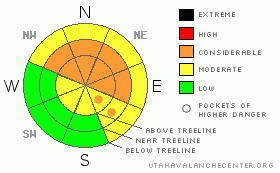
BOTTOM LINE
Danger by aspect and elevation on slopes approaching 35° or steeper.
(click HERE for tomorrow's danger rating)
|
Danger Rose Tutorial
|
The avalanche danger is CONSIDERABLE on high & mid elevation shady slopes meaning human triggered avalanches are probable, natural avalanches possible. Unstable slabs exist on these slopes. All other slopes have a MODERATE avalanche danger, except for slopes that face the sun at low elevations which have an avalanche danger of LOW.
Use conservative decision making, careful route finding, and good travel habits. Training and experience are essential. Avoid lulling about in run-out areas. |
|
|
CURRENT CONDITIONS |

|
The weekend’s storm has cleared out leaving behind a messy ridge of high pressure. Overnight lows hover around zero while daytime highs reach into the upper thirties. Winds continue to blow consistently out of the southwest loading up our north through east facing aspects. It's T-R-I-C-K-Y out there at the moment. There is no real base for the machine to hook up. Travel off road is very difficult. In addition, our house of cards snowpack structure is very weak, and natural avalanches continue to occur. |
|
|
RECENT ACTIVITY |

|
In the wake of last weekend’s big storm Ted & I were able to get out yesterday and survey the damage. The storm produced a large natural avalanche cycle on the shady slopes (read north through east). Unfortunately, not all the shady slopes slid. Those that didn't are incredibly sensitive. A small pillow of snow blowing out of a tree was enough to produce this avalanche which failed at the ground. |
|
|
THREAT #1 |

|
| WHERE |
PROBABILITY |
SIZE |
TREND |
|
|
|
|
| |
|
|
Over the next
24
hours.
|
|
|
Last weekends storm snow sits on top of a base with the strength of an intricate Christmas tree ornament. The tiny structures at the ground are just barely supporting the weight of the new snow. Any additional weight is enough to overload them which produce avalanches running on the ground. I mean *any* weight, even a pillow of snow falling out of a tree!
As daytime high temperatures rise into the upper thirties & winds push snow out of the west - southwest, the new snow will continue to gain strength, taking on more slab like properties. In the long run, this is a good thing. However, it creates a very scary avalanche dragon in the short term. While the slab gains strength, the facets do not. This strengthening of the slab will produce bigger avalanches as we move into the weekend, and it will take the weight of a rider to trigger them. You don't need to be on the slopes to trigger them directly, our cousins in the central Wasatch are remote triggering avalanches from as far as 350' away. This means avalanches could even be triggered from the bottom of the slopes in the run-out areas.
The snowpack needs a few more storms before we can pronounce it healthy again. For the mean time, take it easy out there and avoid slopes that had snow on them before this last storm. |
|
|
THREAT #2 |

|
| WHERE |
PROBABILITY |
SIZE |
TREND |

|
|
|
|
| |
|
|
Over the next
24
hours.
|
|
|
The traveling conditions are such that it would be very difficult for a rider to access our high elevation slopes. If someone does get up there however, they will find a fresh wind slab on top of the existing storm snow/facet interface. These slopes are essentially mine fields; incredibly dangerous places that no one should be on right now. |
|
|
MOUNTAIN WEATHER |

|
You can expect cloudy skies today before things clear up going into tomorrow. For the rest of the week, a "dirty ridge" exists, meaning a mix of partly sunny/partly cloudy skies. Overnight, temperatures will drop down to 10 or so, and day time high's will reach just above freezing. No snow accumulation is expected for the next 5 days. Things may change a bit towards Christmas where we could see another shot of snow. |
|
|
GENERAL ANNOUNCEMENTS |
The information in this advisory expires 24 hours after the date and time posted. Craig Gordon will be update this forecast by 7:00 AM Saturday December 19th.
If you’re getting out and about and trigger an avalanche or see anything interesting please drop me an email at craig@utahavalanchecenter.org or call 801-231-2170
Also, now is a great time to schedule one of our free avalanche awareness presentations for your group or club. Email or call me and we’ll get you booked before things get too crazy. |
|
|
This information does not apply to developed ski areas or highways where avalanche control is normally done. This advisory is from the U.S.D.A. Forest Service, which is solely responsible for its content. This advisory describes general avalanche conditions and local variations always occur. |
|
This advisory provided by the USDA Forest Service, in partnership with:
The Friends of the Utah Avalanche Center, Utah Division of State Parks and Recreation, Utah Division of Emergency Management, Salt Lake County, Salt Lake Unified Fire Authority and the friends of the La Sal Avalanche Center. See our Sponsors Page for a complete list. |
