AVALANCHE WATCH »
The risk of an avalanche is expected to increase significantly
but the timing and location are still uncertain. Stay tuned for updates.
|
 |
Notice: AN AVALANCHE WATCH HAS BEEN ISSUED FOR THE MOUNTAINS OF UTAH, INCLUDING THE WESTERN UINTAS. HEAVY SNOWFALL AND STRONG WINDS ARE EXPECTED TO CREATE DANGEROUS AVALANCHE CONDITIONS SATURDAY NIGHT AND SUNDAY. THIS WATCH DOES NOT INCLUDE SKI AREAS OR HIGHWAYS WHERE AVALANCHE CONTROL IS NORMALLY DONE. |
|
|
SPECIAL ANNOUNCEMENT |
 |
Mirror Lake Highway is officially closed |
|
|
BOTTOM LINE
Danger by aspect and elevation on slopes approaching 35° or steeper.
(click HERE for tomorrow's danger rating)
|
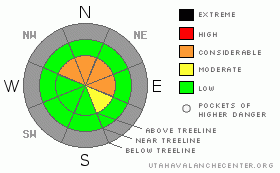
Danger Rose Tutorial
|
The avalanche danger is CONSIDERABLE in steep, wind drifted, upper elevation terrain facing east, northeast, north and northwest, especially on slopes with a pre-existing snowpack. Natural avalanches are possible, human triggered avalanches are likely in this type of terrain. Out of the wind zone and on sun exposed slopes the avalanche danger is generally LOW this morning, possibly rising to MODERATE by days end and human triggered avalanches will be possible as the snow stacks up. |
|
|
CURRENT CONDITIONS |

|
The first in a series of moist and relatively mild Pacific storms moved through the region overnight. Two inches of new snow was recorded at Trial Lake and temperatures are noticeably warmer, in the low to mid 20’s. West and southwest winds increased late yesterday and are blowing 15-25 mph with gusts in the low 30’s along the high ridges. Riding and turning conditions remain shallow and rocky, but a promising looking storm should open up more possibilities once the dust settles. |
|
|
RECENT ACTIVITY |

|
Click here for a look at yesterday's observations. |
|
|
THREAT #1 |

|
| WHERE |
PROBABILITY |
SIZE |
TREND |
|
|
|
|
| |
|
|
Over the next
24 hours.
|
|
|
The next couple of days will be tricky and it’ll be a time of increasing avalanche danger. As a matter of fact, we expect to issue an Avalanche Warning with the incoming storm and here’s why. With only two feet of total snow on the ground, our snowpack is shallow and structurally challenged and has grown very weak and sugary over time. It won’t take much weight before it fails and the region experiences a widespread avalanche cycle. The pattern of avalanche activity should be pretty straight forward and I expect the majority of avalanches will occur on upper elevation, shady slopes- those are the ones facing the north half of the compass. Sun exposed slopes have very little pre-existing snow and I don’t anticipate as much activity on these.
The bigger problem is we’ve been powder starved this season and we’re gonna want to get out and ride now that the winters first big storm is on the way. Remember- the snowpack will see this storm differently than we do. Many early season avalanche accidents and close calls occur when we don’t think there’s enough snow to slide. You’re best bet the next couple of days is to have some patience and as the snow stacks up think about riding low angle terrain or south facing slopes. |
|
|
MOUNTAIN WEATHER |

|
A moist southwest flow will usher in a series of storms today through Monday morning. The first wave is crossing the region this morning and we should see a couple more inches out of this impulse before an early morning break. Winds will remain manageable for most of the day, blowing out of the southwest at 10-20 mph with gusts in the low 30’s along the high ridges. Another shot of moisture works into the area late this afternoon and snow accumulations in the 2”-4” range are a good bet. High temperatures will feel downright balmy today, reaching into the mid to upper 20’s. Overnight lows dip into the upper teens. A more vigorous system moves through the region late tonight and Sunday producing significant snow and strong winds. Storm totals by Monday morning should be in the two foot range. High pressure builds for the latter half of the week. |
|
|
GENERAL ANNOUNCEMENTS |
The information in this advisory expires 24 hours after the date and time posted, but will be updated by 7:00 AM Sunday December 13th.
If you’re getting out and about and trigger an avalanche or see anything interesting please drop me an email at craig@utahavalanchecenter.org or call 801-231-2170
Also, now is a great time to schedule one of our free avalanche awareness presentations for your group or club. Email or call me and we’ll get you booked before things get too crazy. |
|
|
This information does not apply to developed ski areas or highways where avalanche control is normally done. This advisory is from the U.S.D.A. Forest Service, which is solely responsible for its content. This advisory describes general avalanche conditions and local variations always occur. |
|
This advisory provided by the USDA Forest Service, in partnership with:
The Friends of the Utah Avalanche Center, Utah Division of State Parks and Recreation, Utah Division of Emergency Management, Salt Lake County, Salt Lake Unified Fire Authority and the friends of the La Sal Avalanche Center. See our Sponsors Page for a complete list. |
