SPECIAL ANNOUNCEMENT |
 |
Mirror Lake Highway is currently open, but don't let this easy access to the western Uintas lull you into a false sense of security just because you can see your car from a nearby ridge or mountain top. The Uinta snowpack is notoriously sketchy and much weaker than you might find in the central Wasatch. If you're getting into steep terrain, be prepared for your own self rescue- that means wear and know how to use an avalanche beacon, shovel and probe. |
|
|
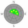
BOTTOM LINE
Danger by aspect and elevation on slopes approaching 35° or steeper.
(click HERE for tomorrow's danger rating)
|
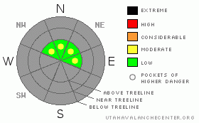
Danger Rose Tutorial
|
While the avalanche danger is generally LOW, there are still places where you could trigger a slide today. Likely suspects are steep, upper elevation wind drifted slopes, especially those with a pre-existing snowpack, facing east, northeast, north and northwest. In this type of terrain a MODERATE avalanche danger exists and human triggered avalanches are possible. |
|
|
CURRENT CONDITIONS |

|
Skies cleared out late yesterday as high pressure becomes firmly entrenched over the region. Currently, temperatures are in the mid teens and northeasterly winds are blowing 10-20 mph with a few gusts in the low 30's along the high ridges. If you're looking for a few early season turns or just want to take the sled out for a spin I gotta tell you, it's pretty grim out there. High and dry weather along with no measurable new snowfall for a week has left the Uintas looking white from far, but they're far from white. Above about 9,500' total snow depths only average 2' or so. Limited riding and turning conditions can be found on upper elevation, north facing, rock free slopes and meadows and low angle terrain is your best bet for turns. |
|
|
RECENT ACTIVITY |

|
Click here for snowpits and recent pictures. |
|
|
THREAT #1 |

|
| WHERE |
PROBABILITY |
SIZE |
TREND |
|
|
|
|
| |
|
|
Over the next
24
hours.
|
|
|
Friday's southerly winds were ruthless, blasting all day in the 30's and 40's with a few gusts in the 50's along the upper elevation ridges and peaks. Then to add insult to injury, late yesterday and overnight, winds switched to the northeast. Winds have been all over the map, finding what little snow there is available for transport and loading slopes in unusual places.
Today be on the lookout for and avoid fat rounded pillows of snow and fresh wind drifts. These hard slabs will feel very strong under your skis or sled, but are resting on weak sugary snow and will have a hollow drum-like sound. They're most prevalent not only along the leeward side of upper elevation ridges and around chutes and gullies, but also formed much lower downslope than you might expect. Given the lack of snow cover right now and all the obstacles buried under our thin façade of snow, getting caught in even a small slide could result in season ending consequences. |
|
|
MOUNTAIN WEATHER |

|
High pressure takes hold of our weather pattern today, lingering through at least mid week, providing mostly sunny skies and warming temperatures. Today, northeasterly winds will be a nuisance, blowing in the 20's and 30's before dying off late this afternoon. High temperatures reach into the low to mid 30's with overnight lows near 20 degrees. Looking into the future, a small glimmer of hope for a storm late in the week, but right now there are no big storms in sight. |
|
|
GENERAL ANNOUNCEMENTS |
The information in this advisory expires 24 hours after the date and time posted, but will be updated by 7:00 AM Saturday December 5th.
If you’re getting out and about and trigger an avalanche or see anything interesting please drop me an email at craig@utahavalanchecenter.org or call 801-231-2170
Also, now is a great time to schedule one of our free avalanche awareness presentations for your group or club. Email or call me and we’ll get you booked before things get too crazy. |
|
|
This information does not apply to developed ski areas or highways where avalanche control is normally done. This advisory is from the U.S.D.A. Forest Service, which is solely responsible for its content. This advisory describes general avalanche conditions and local variations always occur. |
|
This advisory provided by the USDA Forest Service, in partnership with:
The Friends of the Utah Avalanche Center, Utah Division of State Parks and Recreation, Utah Division of Emergency Management, Salt Lake County, Salt Lake Unified Fire Authority and the friends of the La Sal Avalanche Center. See our Sponsors Page for a complete list. |
