SPECIAL ANNOUNCEMENT |
 |
Mirror Lake Highway is currently open, but don't let this easy access to the western Uintas lull you into a false sense of security just because you can see your car from a nearby ridge or mountain top. The Uinta snowpack is notoriously sketchy and much weaker than you might find in the central Wasatch. If you're getting into steep terrain, be prepared for your own self rescue- that means wear and know how to use an avalanche beacon, shovel and probe. |
|
|
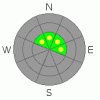
BOTTOM LINE
Danger by aspect and elevation on slopes approaching 35° or steeper.
(click HERE for tomorrow's danger rating)
|

Danger Rose Tutorial
|
While the avalanche danger is generally LOW, there are still places where you could trigger a slide the next few days. Likely suspects are steep, upper elevation wind drifted slopes, especially those with a pre-existing snowpack, facing east, northeast, north and northwest. In this type of terrain a MODERATE avalanche danger exists and human triggered avalanches are possible. |
|
|
CURRENT CONDITIONS |

|
High and dry weather along with no measurable snowfall for about a week has left the Uintas looking white from far, but they are far from white. Above about 9,500' total snow depths only average 2' or so. Limited riding and turning conditions can be found on upper elevation, north facing, rock free slopes and meadows and low angle terrain is your best bet for turns. |
|
|
RECENT ACTIVITY |

|
A small wind loaded pocket was intentionally triggered in Murdock Bowl mid week. Click here for details. |
|
|
THREAT #1 |

|
| WHERE |
PROBABILITY |
SIZE |
TREND |
|
|
|
|
| |
|
|
Over the next
24
hours.
|
|
|
While they may be a little less reactive than even a couple of days ago, there's a few old wind drifts along the leeward side of upper elevation ridges and around chutes and gullies. While easy to detect and manageable in size, given the lack of snow cover right now and all the obstacles buried under our thin façade of snow, getting caught in even a small slide could result in season ending consequences. |
|
|
MOUNTAIN WEATHER |

|
A splitting system will graze Utah late Friday into early Saturday, but there's not much in the way of snow expected. For Friday, skies should be partly cloudy and high temperatures will reach into the low 40's. By days end south and southwest winds should increase into the 20's and 30's along the high ridges. Cloudy skies and a few flurries are on tap for Saturday with a return to high pressure for Sunday into early next week. |
|
|
GENERAL ANNOUNCEMENTS |
The information in this advisory expires 24 hours after the date and time posted, but will be updated by 7:00 AM Saturday November 28th.
If you’re getting out and about and trigger an avalanche or see anything interesting please drop me an email at craig@utahavalanchecenter.org or call 801-231-2170
Also, now is a great time to schedule one of our free avalanche awareness presentations for your group or club. Email or call me and we’ll get you booked before things get too crazy. |
|
|
This information does not apply to developed ski areas or highways where avalanche control is normally done. This advisory is from the U.S.D.A. Forest Service, which is solely responsible for its content. This advisory describes general avalanche conditions and local variations always occur. |
|
This advisory provided by the USDA Forest Service, in partnership with:
The Friends of the Utah Avalanche Center, Utah Division of State Parks and Recreation, Utah Division of Emergency Management, Salt Lake County, Salt Lake Unified Fire Authority and the friends of the La Sal Avalanche Center. See our Sponsors Page for a complete list. |
