SPECIAL ANNOUNCEMENT |
 |
I’ll be giving a free avalanche awareness talk at Tri-City Performance in Centerville on Saturday, November 14th at 2:00. Hope to see y’all there!
|
|
|
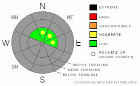
BOTTOM LINE
Danger by aspect and elevation on slopes approaching 35° or steeper.
(click HERE for tomorrow's danger rating)
|
Danger Rose Tutorial
|
The avalanche danger is generally LOW this morning and may rise to MODERATE on steep upper elevation wind drifted slopes. While relatively small, manageable in size and pockety in nature, a person will be able to trigger shallow wind slabs, especially on steep slopes with a pre-existing snowpack.
|
|
|
CURRENT CONDITIONS |

|
A few early season storms have laid the cornerstone of our winter snowpack. While most sun exposed terrain is pretty bare, upper elevation north facing slopes are harboring several storms worth of snow. Above 10,000’ total snow depths average 12”-16”. While it’s white from far… it’s far from white and early season conditions could easily rack up a costly repair on your sled or even worse, a total knee reconstruction. |
|
|
RECENT ACTIVITY |

|
No recent avalanche activity to report |
|
|
THREAT #1 |

|
| WHERE |
PROBABILITY |
SIZE |
TREND |
|
|
|
|
| |
|
|
Over the next
24 hours.
|
|
|
There’s not a whole lot going on in the avalanche world at the moment. As a matter of fact, you probably stand a better chance of hitting a buried rock or stump than you do of triggering an avalanche, but a good looking storm is bearing down on the state and that may start to change the equation. As the new snow starts to stack up, small loose sluffs will be the main concern. While manageable in size, take care that one doesn’t knock you off your skis or sled and body slam you into a season ending obstacle.
|
|
|
THREAT #2 |

|
| WHERE |
PROBABILITY |
SIZE |
TREND |
|
|
|
|
| |
|
|
Over the next
24 hours.
|
|
|
As the cold front slams into the region, gusty west and northwest winds will surely create a fresh batch of wind slabs and these will be sensitive to the weight of a person. Remember to look for clues- cracking around your skis or board and whoomphing sounds are indicators to unstable snow.
|
|
|
MOUNTAIN WEATHER |

|
A fast moving cold storm dives into the region today and we should see storm totals in the 4”-6” range before this system exits the state and high pressure begins to build. West and northwest winds increase as the front arrives; averaging 15-25 mph, gusting into the 30’s and 40’s along the ridges. Temperatures are gonna feel winter-like this weekend with highs in the low 20’s and overnight lows near zero. Partly cloudy skies are on tap for Sunday with a warming trend developing for early part of the upcoming week.
http://www.wrh.noaa.gov/slc/wxbriefing/wxb13nov2009/player.html
|
|
|
GENERAL ANNOUNCEMENTS |
|
The information in this advisory expires 24 hours after the date and time posted. It’s still pretty early in the season and until there’s enough snow to really get things rolling, I will update this information as conditions warrant.
If you’re getting out and about and trigger an avalanche or see anything interesting please drop me an email at craig@utahavalanchecenter.org or call 801-231-2170
Also, now is a great time to schedule one of our free avalanche awareness presentations for your group or club. Email or call me and we’ll get you booked before things get too crazy.
|
|
|
This information does not apply to developed ski areas or highways where avalanche control is normally done. This advisory is from the U.S.D.A. Forest Service, which is solely responsible for its content. This advisory describes general avalanche conditions and local variations always occur. |
|
This advisory provided by the USDA Forest Service, in partnership with:
The Friends of the Utah Avalanche Center, Utah Division of State Parks and Recreation, Utah Division of Emergency Management, Salt Lake County, Salt Lake Unified Fire Authority and the friends of the La Sal Avalanche Center. See our Sponsors Page for a complete list. |
