SPECIAL ANNOUNCEMENT |
 |
Tomorrow, Sunday April 12th will be our last scheduled advisory for the season. |
|
|
BOTTOM LINE
Danger by aspect and elevation on slopes approaching 35° or steeper.
(click HERE for tomorrow's danger rating)
|

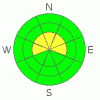
Danger Rose Tutorial
|
At and above treeline on steep slopes facing the north half of the compass, there's a few wind slabs that will remain sensitive to the weight of a person today. In this type of terrain a MODERATE avalanche danger exists and human triggered avalanches are possible.
Out of the wind zone the avalanche danger is generally LOW. |
|
|
CURRENT CONDITIONS |

|
A storm system well to the south of our region spread clouds into the area overnight, keeping temperatures quite mild. Currently at 10,000’ it’s 27 degrees and at the trailheads right around 36 degrees. Winds are blowing out of the south and southeast, averaging 10-20 mph with a few gusts in the low 30’s along the high peaks. In general, the riding and turning conditions are pretty underwhelming, but a few patches of soft settled powder can still be found on mid and upper elevation, wind sheltered northerly facing slopes.
|
|
|
RECENT ACTIVITY |

|
No new significant avalanche activity to report.
Click here for a list of recent avalanche activity in the Uinta's.
For more photos of recent avalanche activity click here |
|
|
THREAT #1 |

|
| WHERE |
PROBABILITY |
SIZE |
TREND |
|
|
|
|
| |
|
|
Over the next
24
hours.
|
|
|
Friday’s winds were gusty along the upper elevation ridges and both Ted and I were surprised at how much snow was getting blown around, forming shallow yet sensitive slabs on steep, leeward slopes. These manageable drifts are breaking about a foot deep, on light density snow which fell early during Wednesday nights storm. While not particularly dangerous and predictably breaking around or below your sled or skis, there may be a pocket or two that could surprise you in sustained steep terrain, packing more of a punch than you might expect. You don’t have to go into this blindly, nor do you need to be a snow scientist. Gather some information by tweaking small road cuts and test slopes to see how they’re reacting before committing to big terrain. |
|
|
THREAT #2 |

|
| WHERE |
PROBABILITY |
SIZE |
TREND |

|
|
|
|
| |
|
|
Over the next
24
hours.
|
|
|
For better or worse, nearly everyone who’s spent time in the mountains during the winter months has a cornice story. Talking with other folks around the range, we’re amazed at how big cornices have grown, especially during the last storm cycle. As a matter of fact, they’re epically huge and may break back much further than you’d think. I’d continue to give these unpredictable pieces of snow the respect they deserve and avoid messing around with them.
|
|
|
MOUNTAIN WEATHER |

|
A storm system in southern Utah will drift far enough northward to give us a few snow showers throughout the day with a better chance of accumulating snow tonight. We might be able to squeak 3”-6” out of it before high pressure builds late tonight through Monday. Winds switch to the north and northeast late today and increase, gusting into the mid 30’s along the ridges. High temperatures don’t vary much through the day reaching into the upper 30’s at 8,000’ and near freezing at 10,000’. Overnight lows dip into the low 20’s. Warmer temperatures and sunny skies prevail for Sunday and Monday and another cold storm with significant snow is slated for late Tuesday. I’ll have a better handle on strength and timing of this system for tomorrow’s advisory.
|
|
|
GENERAL ANNOUNCEMENTS |
Remember- your observations help to save other riders lives. So if you see or trigger any avalanches please let me know what your seeing. You can reach me at 801-231-2170 or craig@utahavalanchecenter.org
Also, Beacon Basin is up and running and located inside the orange fencing on the northeast corner of the Nobletts Trailhead.
The information in this advisory expires 24 hours after the date and time posted. I'll update this advisory by 7:00 am on Sunday Apr. 12, 2009.
Sunday April 12th will be our last scheduled advisory for the season. |
|
|
This information does not apply to developed ski areas or highways where avalanche control is normally done. This advisory is from the U.S.D.A. Forest Service, which is solely responsible for its content. This advisory describes general avalanche conditions and local variations always occur. |
|
This advisory provided by the USDA Forest Service, in partnership with:
The Friends of the Utah Avalanche Center, Utah Division of State Parks and Recreation, Utah Division of Emergency Management, Salt Lake County, Salt Lake Unified Fire Authority and the friends of the La Sal Avalanche Center. See our Sponsors Page for a complete list. |
