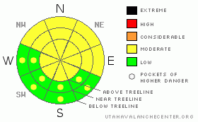
BOTTOM LINE
Danger by aspect and elevation on slopes approaching 35° or steeper.
(click HERE for tomorrow's danger rating)
|

Danger Rose Tutorial
|
The danger of wet avalanches will rise from LOW this morning to MODERATE during the heat of the day on steep, sun exposed slopes and human triggered avalanches will be possible.
As the upcoming storm materializes and new snow stacks up, the avalanche danger will rise accordingly. |
|
|
CURRENT CONDITIONS |

|
High clouds moved into the region late yesterday, but early this morning skies have cleared and temperatures cooled off the past few hours. Currently at 10,000’ it’s 29 degrees and down at the trailheads right around 34 degrees. Southwest winds picked up at 3:00 this morning and are averaging 30 mph along the ridges with gusts near 45 mph near the high peaks. Riding and turning conditions are a mixed bag. Down low you’ll find hard, crusty snow early this morning that’ll soften to a corn-like surface later in the day, before turning to unsupportable glop. However, a few patches of cold dry powder will still be found on high elevation, due north facing slopes.
|
|
|
RECENT ACTIVITY |

|
A few wet, afternoon sluffs like this one of Hayden Peak, but in general it’s pretty quiet on the avalanche front.
Click here for a list of recent avalanche activity in the Uinta's.
For more photos of recent avalanche activity click here |
|
|
THREAT #1 |

|
| WHERE |
PROBABILITY |
SIZE |
TREND |

|
|
|
|
| |
|
|
Over the next
24
hours.
|
|
|
Today’s avalanche concerns involve damp snow and the possibility of triggering wet slides during the heat of the day, especially on mid and lower elevation slopes facing the north half of the compass. I think today’s afternoon cloud cover will help temper most of the avalanche activity, but a good rule of thumb is to get off of and out from under steep, sun exposed slopes as they’re getting baked by strong afternoon sun. Also, avoid terrain traps like gullies and road cuts where debris can pile up deeply.
Another storm rolls in late this afternoon and avalanche conditions will change in the next few days as we go back into a winter-like pattern. We’ll need to readjust our avalanche radar as well. This isn’t going to be a huge storm, but as new snow stacks up be sure to stomp on road banks and small test slopes to see how they’re reacting before committing to big terrain.
|
|
|
THREAT #2 |

|
| WHERE |
PROBABILITY |
SIZE |
TREND |

|
|
|
|
| |
|
|
Over the next
24
hours.
|
|
|
Cornices have grown huge and may continue to break much further back than you might expect. Getting on the wrong side of a boxcar size piece of snow will definitely ruin your day. I’d give these unpredictable monsters plenty of respect and avoid walking out on one to see what’s on the other side. |
|
|
MOUNTAIN WEATHER |

|
Today we can expect increasing clouds and southerly winds ahead of a moist Pacific storm system slated to impact the region beginning this afternoon. Today’s highs reach into the mid 40’s at 8,000’ and upper 30’s at 10,000’. Snow should begin around dinner time, continuing overnight and into the morning hours Thursday. The storm winds down Thursday afternoon and I think a foot of snow is a pretty good bet. It looks like a break in the action for Friday with another system dropping into the area for the upcoming weekend.
|
|
|
GENERAL ANNOUNCEMENTS |
Remember- your observations help to save other riders lives. So if you see or trigger any avalanches please let me know what your seeing. You can reach me at 801-231-2170 or craig@utahavalanchecenter.org
Also, Beacon Basin is up and running and located inside the orange fencing on the northeast corner of the Nobletts Trailhead.
The information in this advisory expires 24 hours after the date and time posted. I'll update this advisory by 7:00 am on Saturday Apr. 11, 2009.
Sunday April 12th will be our last scheduled advisory for the season. |
|
|
This information does not apply to developed ski areas or highways where avalanche control is normally done. This advisory is from the U.S.D.A. Forest Service, which is solely responsible for its content. This advisory describes general avalanche conditions and local variations always occur. |
|
This advisory provided by the USDA Forest Service, in partnership with:
The Friends of the Utah Avalanche Center, Utah Division of State Parks and Recreation, Utah Division of Emergency Management, Salt Lake County, Salt Lake Unified Fire Authority and the friends of the La Sal Avalanche Center. See our Sponsors Page for a complete list. |

