BOTTOM LINE
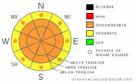
Danger by aspect and elevation on slopes approaching 35° or steeper.
(click HERE for tomorrow's danger rating)
|

Danger Rose Tutorial
|
At all elevations the danger of wet avalanches will quickly rise from MODERATE this morning to CONSIDERABLE on all steep, sun exposed slopes. Human triggered avalanches are probable, natural avalanches possible. Avoid steep slopes and avalanche runout zones especially during the heat of the day. |
|
|
CURRENT CONDITIONS |

|
One last gasp of snow yesterday added another 6” to the already ridiculously deep totals we’ve received in the past two weeks. By all accounts this has been an amazing storm cycle with nearly 90” stacking up around Chalk Creek, 72” in the Trial Lake area and 58” around Daniels. We’re slowly drying out as high pressure builds across the region and skies are partly cloudy this morning. Northeast winds were active yesterday, blowing in the 20’s and 30’s, but died down around 8:00 last night and are currently blowing less than 10 mph even along the highest wind exposed peaks. This morning it’s 12 degrees at 10,000’ and near 20 degrees at the trailheads. The over-the head, over-the-hood, white room riding conditions will go from hero to zero in a hurry today, as the snowpack gets a strong dose of spring-like sun. If you wanna get the goods an early start is essential.
|
|
|
RECENT ACTIVITY |

|
Shallow, natural, soft slabs, up to a foot deep, were reported in steep upper elevation terrain yesterday.
Click here for a list of recent avalanche activity in the Uinta's.
For more photos of recent avalanche activity click here |
|
|
THREAT #1 |

|
| WHERE |
PROBABILITY |
SIZE |
TREND |

|
|
|
|
| |
|
|
Over the next
24
hours.
|
|
|
Considering the sheer amount of snow we’ve received, the snowpack has been pretty well behaved. Unfortunately that’s all about to come to a screeching halt as all the new snow gets its first taste of strong sunshine in nearly two weeks. The new snow will change rapidly and as you already know, that’s when snow gets cranky. Minimizing your chances of triggering or getting caught in a slide today is going to be the big ticket item and it’s pretty straight forward. Avoid being on or underneath steep, sun exposed slopes especially during the heat of the day. Today’s avalanches could break deeper than you might expect, into older storm layers, stacking up deep piles of cement-like, bone snapping debris. In addition, you’ll want to think about your slope choices and avoid terrain traps like gullies, benches and road cuts.
|
|
|
THREAT #2 |

|
| WHERE |
PROBABILITY |
SIZE |
TREND |

|
|
|
|
| |
|
|
Over the next
24
hours.
|
|
|
Cornices have grown huge and are breaking much further back than you might expect. Getting on the wrong side of a boxcar size piece of snow will definitely ruin your day. I’d give these unpredictable monsters plenty of respect and avoid walking out on one to see what’s on the other side. |
|
|
MOUNTAIN WEATHER |

|
High pressure camps out over the region the next few days, producing sunny skies, warm temperatures and generally light winds. Highs today reach into the mid 30’s at 8,000’ and near freezing at 10,000’. Overnight lows dip into the mid teens. Winds will be light, out of the north, blowing less than 20 mph along the ridges. Clear and slightly warmer Monday, with temperatures soaring into the mid 40’s Tuesday ahead of another round of snow slated for midweek.
|
|
|
GENERAL ANNOUNCEMENTS |
Remember- your observations help to save other riders lives. So if you see or trigger any avalanches please let me know what your seeing. You can reach me at 801-231-2170 or craig@utahavalanchecenter.org
Also, Beacon Basin is up and running and located inside the orange fencing on the northeast corner of the Nobletts Trailhead.
The information in this advisory expires 24 hours after the date and time posted. I'll update this advisory by 7:00 am on Wednesday Apr. 8, 2009.
Sunday April 12th will be our last scheduled advisory for the season. |
|
|
This information does not apply to developed ski areas or highways where avalanche control is normally done. This advisory is from the U.S.D.A. Forest Service, which is solely responsible for its content. This advisory describes general avalanche conditions and local variations always occur. |
|
This advisory provided by the USDA Forest Service, in partnership with:
The Friends of the Utah Avalanche Center, Utah Division of State Parks and Recreation, Utah Division of Emergency Management, Salt Lake County, Salt Lake Unified Fire Authority and the friends of the La Sal Avalanche Center. See our Sponsors Page for a complete list. |

