BOTTOM LINE
Danger by aspect and elevation on slopes approaching 35° or steeper.
(click HERE for tomorrow's danger rating)
|
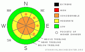
Danger Rose Tutorial
|
The avalanche danger is generally MODERATE early this morning, but will quickly rise to CONSIDERABLE once the storm arrives. Human triggered avalanches will be probable and natural avalanches possible, especially on steep wind drifted slopes.
In wind sheltered terrain the danger of triggering avalanches within the new storm snow will rise from LOW to MODERATE with the storm’s arrival and human triggered avalanches will be possible on slopes steeper than about 35 degrees. |
|
|
CURRENT CONDITIONS |

|
A strong cold front is bearing down on the region and it should be pounding snow by about mid morning. Ahead of the system, clouds started streaming in late last night. Southwest winds began cranking around midnight with hourly averages in the 40’s, gusting into the 60’s along the ridges. Currently, temperatures are in the upper 20’s at 10,000’ and right around freezing at the trailheads. |
|
|
RECENT ACTIVITY |

|
No significant new avalanche activity.
Click here for a list of recent avalanche activity in the Uinta's.
For more photos of recent avalanche activity click here |
|
|
THREAT #1 |

|
| WHERE |
PROBABILITY |
SIZE |
TREND |

|
|
|
|
| |
|
|
Over the next
24
hours.
|
|
|
Strong winds will accompany today’s system and they’ll be coming from every direction of the compass. The prefrontal southwesterly winds are finding enough snow to blow around and form shallow, stiff slabs on mid and upper elevation slopes facing the north half of the compass. The bigger concern is once the storm kicks in and it starts snowing, then winds shift to the west and northwest and all slopes get in on the act. With plenty of new snow expected, sensitive wind slabs will form at a rapid rate.
It’ll be a day of changing weather and avalanche conditions and as the day progresses you’ll need to re-evaluate your terrain choices. This mornings manageable wind drifts will become more widespread, deeper and less manageable later in the day. Avalanches triggered today could break into older storm snow from earlier in the week, creating a deep, scary slide. |
|
|
THREAT #2 |

|
| WHERE |
PROBABILITY |
SIZE |
TREND |

|
|
|
|
| |
|
|
Over the next
24
hours.
|
|
|
Once the front arrives by around 11:00 or so, snowfall rates are expected to be in the 2” an hour range and shallow, natural avalanche activity on steep slopes is a good bet. As the new snow stacks up, sluffs and soft slab avalanches will have a head of steam, packing a big enough punch to ruin your day. As the day wares on you’ll want to avoid being at the bottom of steep, sustained slopes and avalanche runout zones. |
|
|
MOUNTAIN WEATHER |

|
Snow develops this morning ahead of a strong cold front that will likely enter the area between 10am and noon. A period of heavy snow accompanies the front and could produce snowfall rates greater than two inches an hour through the early afternoon. Winds will be an issue, switching to the northwest with frontal passage, gusting into the 70’s and 80’s along the ridges. We’ve probably already reached our daytime high temperature and it’ll be dropping into the single digits overnight. Snow showers continue during the late afternoon and evening before tapering off Monday morning. Storm totals of a foot still seem pretty reasonable. Another storm slides into the region late Tuesday. |
|
|
GENERAL ANNOUNCEMENTS |
Remember- your observations help to save other riders lives. So if you see or trigger any avalanches please let me know what your seeing. You can reach me at 801-231-2170 or craig@utahavalanchecenter.org
Also, Beacon Basin is up and running and located inside the orange fencing on the northeast corner of the Nobletts Trailhead.
The information in this advisory expires 24 hours after the date and time posted. I'll update this advisory by 7:00 am on Wednesday Apr. 2, 2009. |
|
|
This information does not apply to developed ski areas or highways where avalanche control is normally done. This advisory is from the U.S.D.A. Forest Service, which is solely responsible for its content. This advisory describes general avalanche conditions and local variations always occur. |
|
This advisory provided by the USDA Forest Service, in partnership with:
The Friends of the Utah Avalanche Center, Utah Division of State Parks and Recreation, Utah Division of Emergency Management, Salt Lake County, Salt Lake Unified Fire Authority and the friends of the La Sal Avalanche Center. See our Sponsors Page for a complete list. |
