BOTTOM LINE
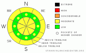
Danger by aspect and elevation on slopes approaching 35° or steeper.
(click HERE for tomorrow's danger rating)
|
Danger Rose Tutorial
|
The danger of wet avalanches is LOW this morning, but will rise to MODERATE on steep sun exposed slopes, especially at low and mid elevations during the heat of the day. Human triggered avalanches will be possible.
While not widespread, in upper elevation terrain at and above treeline, the avalanche danger is MODERATE today and human triggered avalanches are possible on steep wind drifted slopes.
|
|
|
CURRENT CONDITIONS |

|
A short-lived break in between storm systems allowed high pressure to build and skies remained clear overnight. Temperatures are 10-15 degrees warmer than yesterday at this time, in the mid teens at both 8,000’ and 10,000’. North and northeast winds are blowing 25-35 mph along the ridges. Cold, deep powder can still be found in mid elevation sheltered terrain, but up high it’s an entirely different story. Strong easterly winds Thursday night gusted into the 80’s and 90’s, damaging much of our upper elevation terrain, producing a wave-like Victory at Sea surface.
|
|
|
RECENT ACTIVITY |

|
No significant new avalanche activity.
Click here for a list of recent avalanche activity in the Uinta's.
For more photos of recent avalanche activity click here |
|
|
THREAT #1 |

|
| WHERE |
PROBABILITY |
SIZE |
TREND |

|
|
|
|
| |
|
|
Over the next
24
hours.
|
|
|
It’s been a stormy week on the eastern front with much of the region receiving 3’-4’ of new snow since Monday. While strong sunshine accompanied yesterday’s toe numbing temperatures, winter-like highs only reached into the mid teens and a thin veil of afternoon cloud cover kept wet avalanche activity at bay. With daytime highs expected to reach into the mid 30’s, today it’s a different story. The new storm snow will react to the big warm up and as you already know, snow gets cranky when it goes through a rapid change. Cloud cover is going to be the wild card today. If it remains sunny, steep mid and lower elevation slopes will become damp and it’ll be easy to trigger wet avalanches during the heat of the day. You’ll want to avoid steep slopes and terrain traps like gullies and road cuts and think about your terrain choices to get back to the rig this afternoon.
|
|
|
THREAT #2 |

|
| WHERE |
PROBABILITY |
SIZE |
TREND |

|
|
|
|
| |
|
|
Over the next
24
hours.
|
|
|
This week’s stormy pattern started off with strong, gusty west and northwest winds and ended with nuking east and northeast winds… an unusual direction for us. As you might’ve guessed, wind loading occurred in odd locations and on slopes we normally see stripped by the wind. The drifts created are easy to detect and look like small hump back whales. Yesterday I found these drifts stubborn and unreactive, but I bet there’s still a pocket or two out there that’ll be sensitive to the weight of a rider today. You know the drill- look for and avoid any fat looking pillow of snow, especially if it sounds hollow like a drum. In addition, cornices have grown large and may break back further than you might expect.
|
|
|
MOUNTAIN WEATHER |

|
Partly cloudy skies with highs in the mid to upper 30’s are on tap for the region today. Winds will be out of the west and northwest, blowing in the 20’s and 30’s along the ridges, before switching to the southwest tonight, gusting into the 50’s. We can expect increasing clouds late this afternoon and tonight with overnight lows in the mid 20’s. An approaching storm system ushers in snow by mid morning Sunday and it looks like a pretty good shot for us. I think a foot is a good bet by Monday morning. A break in the action is slated for Tuesday with more unsettled weather returning mid week.
|
|
|
GENERAL ANNOUNCEMENTS |
Remember- your observations help to save other riders lives. So if you see or trigger any avalanches please let me know what your seeing. You can reach me at 801-231-2170 or craig@utahavalanchecenter.org
Also, Beacon Basin is up and running and located inside the orange fencing on the northeast corner of the Nobletts Trailhead.
The information in this advisory expires 24 hours after the date and time posted. I'll update this advisory by 7:00 am on Sunday Mar. 29, 2009. |
|
|
This information does not apply to developed ski areas or highways where avalanche control is normally done. This advisory is from the U.S.D.A. Forest Service, which is solely responsible for its content. This advisory describes general avalanche conditions and local variations always occur. |
|
This advisory provided by the USDA Forest Service, in partnership with:
The Friends of the Utah Avalanche Center, Utah Division of State Parks and Recreation, Utah Division of Emergency Management, Salt Lake County, Salt Lake Unified Fire Authority and the friends of the La Sal Avalanche Center. See our Sponsors Page for a complete list. |
