SPECIAL ANNOUNCEMENT |
 |
Recent strong winds and heavy snow have prompted us to issue a Special Avalanche Advisory for the western Uinta Mountains. A Considerable avalanche danger exists on steep mid and upper elevation slopes and human triggered avalanches are probable. |
|
|
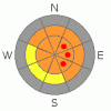
BOTTOM LINE
Danger by aspect and elevation on slopes approaching 35° or steeper.
(click HERE for tomorrow's danger rating)
|

Danger Rose Tutorial
|
In mid and upper elevation terrain at and above treeline, the avalanche danger on steep wind drifted slopes is CONSIDERABLE and human triggered avalanches are probable with some natural avalanche activity possible. Within this terrain there may be a pocket or two of HIGH avalanche danger, especially on slopes with an easterly component and human triggered avalanches are likely on these slopes.
A MODERATE avalanche danger exists in steep, mid elevation, wind sheltered terrain and human triggered sluffs and soft slabs are possible. |
|
|
CURRENT CONDITIONS |

|
24 hour snow totals are nearing 2' in Chalk Creek, 16” at Trial Lake and about a foot in the Daniels area. More of an issue is the wind. Yesterday, west and northwest winds howled along the ridges with hourly averages in the 30’s and gusts in the upper 50’s. I would suspect winds got into mid elevation terrain as well. Currently, light snow is falling, northwest winds are blowing 30-40 mph and temperatures have cooled into the mid teens. |
|
|
RECENT ACTIVITY |

|
No significant new avalanche activity.
Click here for a list of recent avalanche activity in the Uinta's.
For more photos of recent avalanche activity click here |
|
|
THREAT #1 |

|
| WHERE |
PROBABILITY |
SIZE |
TREND |
|
|
|
|
| |
|
|
Over the next
24
hours.
|
|
|
With the transition from spring back to winter we need to recalibrate our avalanche radar and get back into a cold snow groove. Most of the instabilities are at the old snow/new snow interface. If you’re covering a lot of ground today or traveling from one drainage to another, remember- in terrain that received the lion’s share of the recent storm track, there’s plenty of light density snow to blow around and wind drifts along the leeward side of ridges are getting unmanageably deep and dangerous. Now here’s the wild card in the deck- in upper elevation shady terrain all this snow is stacking up on weak, sugary, near surface facets and they may become a player in the equation, especially if there’s a stronger slab overlaying this weak layer. If you’re feeling unsure about the snow you’re riding on, you can dig quick hand pits to see the layers. Better yet, tweak road cuts and observe how the snowpack is reacting to your additional weight. The avalanche danger is less pronounced in areas that received less than a foot of snow the past few days and in wind sheltered terrain. |
|
|
THREAT #2 |

|
| WHERE |
PROBABILITY |
SIZE |
TREND |

|
|
|
|
| |
|
|
Over the next
24
hours.
|
|
|
In wind sheltered terrain the avalanche danger is easier to detect, involving new snow sluffs and shallow soft slabs that break around or just below a person. While manageable in size, these could pack a punch especially on sustained steep slopes. |
|
|
MOUNTAIN WEATHER |

|
A northwest flow over the region will keep snow showers going for most of the morning, though accumulations will only be in the 2”-4” range. Northwest winds should remain active, blowing in the 30’s along the ridges with gusts in the 60’s along the high peaks. High temperatures reach into the upper teens and low 20’s. A break for Friday and Saturday with a quick hitting storm slated to move in on Sunday. |
|
|
GENERAL ANNOUNCEMENTS |
Remember- your observations help to save other riders lives. So if you see or trigger any avalanches please let me know what your seeing. You can reach me at 801-231-2170 or craig@utahavalanchecenter.org
Also, Beacon Basin is up and running and located inside the orange fencing on the northeast corner of the Nobletts Trailhead. In addition, Ted installed a Beacon Park in his neck of the woods, near the Bear River trailhead on the Evanston side of the range, so here's no excuse not to be practicing with your rescue gear.
The information in this advisory expires 24 hours after the date and time posted. I'll update this advisory by 7:00 am on Saturday Mar. 28, 2009. |
|
|
This information does not apply to developed ski areas or highways where avalanche control is normally done. This advisory is from the U.S.D.A. Forest Service, which is solely responsible for its content. This advisory describes general avalanche conditions and local variations always occur. |
|
This advisory provided by the USDA Forest Service, in partnership with:
The Friends of the Utah Avalanche Center, Utah Division of State Parks and Recreation, Utah Division of Emergency Management, Salt Lake County, Salt Lake Unified Fire Authority and the friends of the La Sal Avalanche Center. See our Sponsors Page for a complete list. |
