SPECIAL ANNOUNCEMENT |
 |
We now have three western Uinta specific weather stations up and running.
For Weber Canyon and upper Chalk Creek- Windy Peak (wind and temperature) and Giant Steps (snow depth and temperature)
For the region around Mirror Lake- Lofty Lake Peak (wind and temperature) |
|
|
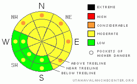
BOTTOM LINE
Danger by aspect and elevation on slopes approaching 35° or steeper.
(click HERE for tomorrow's danger rating)
|
Danger Rose Tutorial
|
The avalanche danger on steep, lower elevation north facing slopes is generally MODERATE this morning and human triggered avalanche are possible. While not widespread, there are pockets of CONSIDERABLE avalanche danger on these same slopes, especially in steep rocky terrain with a shallow weak snowpack. A CONSIDERABLE danger means human triggered avalanches are probable, natural avalanches possible.
In colder upper elevation terrain, the avalanche danger is generally LOW this morning, but will rise to MODERATE on steep slopes as the new storm snow stacks up. |
|
|
CURRENT CONDITIONS |

|
March madness is just starting to gear up for the eastern front and southerly winds have been cranking since about midnight in anticipation of the main event. Averaging 30-40 mph with gusts in the 50’s along the high peaks, they’ll stick around ‘til early afternoon before diminishing. Under mostly cloudy skies, overnight low temperatures only reached 33 degrees at 10,000’ and it’s still 40 degrees at the trailheads. Riding and turning conditions are a bit grim this morning, but perhaps a dusk patrol will be in order with a good burst of afternoon snow on the way. |
|
|
RECENT ACTIVITY |

|
State Parks groomer extraordinaire Joe Donnell found a few natural wet slabs in the Cold Springs area yesterday. These natural slides started out as small point releases during the heat of the day, but quickly broke into old weak snow near rock bands, piling up impressive piles on bone crushing debris. Thanks Joe for the great pics!
Click here for a list of recent avalanche activity in the Uinta's.
For more photos of recent avalanche activity click here |
|
|
THREAT #1 |

|
| WHERE |
PROBABILITY |
SIZE |
TREND |
|
|
|
|
| |
|
|
Over the next
24
hours.
|
|
|
It’s the tale of two snowpacks. At lower elevations the pack is damp and in many places last night’s thin refreeze is only a façade, adding a thin veneer of supportability to the snow surface. Without a solid refreeze for three nights, you can expect to find soggy wet snow, especially on low elevation northerly facing slopes and in terrain that has a thin snowpack. Steep rocky terrain would be a likely suspect. Forecasting for wet avalanches can be a bit deceptive and stability patterns are often hit and miss. Minimizing all the science from the equation and getting back to basics is usually your best bet. Until today’s cold front arrives and welds the snowpack back together I’d continue to avoid steep, lower elevation terrain, particularly slopes facing the north half of the compass. |
|
|
THREAT #2 |

|
| WHERE |
PROBABILITY |
SIZE |
TREND |

|
|
|
|
| |
|
|
Over the next
24
hours.
|
|
|
Periods of heavy snowfall are expected this afternoon and if the forecast verifies with a foot or more of new snow, the avalanche danger will rise accordingly. In much of our mid and upper elevation terrain, there’s an abundance of hard, slick bed surfaces for avalanches to run on and they may pack a bigger punch than you might expect. You know the drill by now- tweak small test slopes and road banks and see how they’re reacting before blindly charging into steep terrain. |
|
|
MOUNTAIN WEATHER |

|
This morning we can expect mostly cloudy skies, warm temperatures and gusty southerly winds. High temperatures won’t vary much from where we’re at this morning, reaching into the upper 30’s at 10,000’ and mid 40’s at 8,000’. Southwest winds will blow in the 30’s and 40’s with a few gusts in the 60’s along the highest terrain, before mellowing out and switching to the west-northwest around midday. Colder, unstable air filters into the region and a pretty good shot of snow will accompany the front along with the possibility of lightening. Temperatures dive into the mid teens overnight. Snow showers linger into Monday and a foot of new snow seems like a reasonable bet for storm totals. Cool, unsettled weather is on tap for the upcoming week. |
|
|
GENERAL ANNOUNCEMENTS |
Remember- your observations help to save other riders lives. So if you see or trigger any avalanches please let me know what your seeing. You can reach me at 801-231-2170 or craig@utahavalanchecenter.org
Also, Beacon Basin is up and running and located inside the orange fencing on the northeast corner of the Nobletts Trailhead. In addition, Ted installed a Beacon Park in his neck of the woods, near the Bear River trailhead on the Evanston side of the range, so here's no excuse not to be practicing with your rescue gear.
The information in this advisory expires 24 hours after the date and time posted. I'll update this advisory by 7:00 am on Wednesday Mar. 25, 2009. |
|
|
This information does not apply to developed ski areas or highways where avalanche control is normally done. This advisory is from the U.S.D.A. Forest Service, which is solely responsible for its content. This advisory describes general avalanche conditions and local variations always occur. |
|
This advisory provided by the USDA Forest Service, in partnership with:
The Friends of the Utah Avalanche Center, Utah Division of State Parks and Recreation, Utah Division of Emergency Management, Salt Lake County, Salt Lake Unified Fire Authority and the friends of the La Sal Avalanche Center. See our Sponsors Page for a complete list. |
