SPECIAL ANNOUNCEMENT |
 |
We now have three western Uinta specific weather stations up and running.
For Weber Canyon and upper Chalk Creek- Windy Peak (wind and temperature) and Giant Steps (snow depth and temperature)
For the region around Mirror Lake- Lofty Lake Peak (wind and temperature) |
|
|
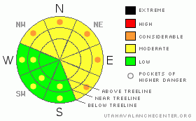
BOTTOM LINE
Danger by aspect and elevation on slopes approaching 35° or steeper.
(click HERE for tomorrow's danger rating)
|
Danger Rose Tutorial
|
The avalanche danger on steep, lower elevation north facing slopes is MODERATE this morning and human triggered avalanche are possible. The danger may rise to CONSIDERABLE on these same slopes, especially during the heat of the day. A CONSIDERABLE danger means human triggered avalanches are probable, natural avalanches possible.
In colder upper elevation terrain, the avalanche danger is generally LOW this morning, rising to MODERATE on steep sunny slopes with daytime heating.
|
|
|
CURRENT CONDITIONS |

|
Skies remained clear overnight, allowing for a shallow refreeze of the snow surface, but in general temperatures are rather sultry this morning. Currently at 10,000’ it’s right around 32 degrees and it’s in the mid 30’s at the trailheads. Southerly winds increased early this morning and are blowing15-25 mph along the ridges with a few gusts in the 30’s along the high peaks. The riding and turning conditions have taken a hard hit since earlier in the week. It’s probably a good day to get your taxes in order and wait for the return of winter which is slated to arrive back in town late tonight.
|
|
|
RECENT ACTIVITY |

|
Pretty quiet other than a damp, shallow avalanche triggered by a cornice drop in the Super Bowl area.
Click here for a list of recent avalanche activity in the Uinta's.
For more photos of recent avalanche activity click here |
|
|
THREAT #1 |

|
| WHERE |
PROBABILITY |
SIZE |
TREND |

|
|
|
|
| |
|
|
Over the next
24
hours.
|
|
|
The snowpack is going through the beginning stages of a mid-life crisis right now- transitioning from a cold winter pack to warm spring-like snowpack. As you already know, snow doesn’t like change, especially rapid change. In upper elevation terrain where the snowpack is deep and overnight low temperatures remain cool, the main concern is loose, shallow wet surface sluffs which are very manageable. The more deceptive avalanche dragon is deep, wet slab avalanches particularly in low elevation terrain where the snowpack is thin, overnight low temperatures have been above freezing since the 19th and avalanches could break into weak snow near the ground.
In either case the best way to avoid getting tangled up in these nasty, slow moving, bone twisting slides is to stay off of and out from under steep sunny slopes, especially during the heat of the day. In addition, think about your exit back to the rig this afternoon and avoid terrain traps like gullies and road cuts where cement-like debris can pile up very deeply. Today’s winds may cool the snow surface at the upper elevations, buying you a little more time out on the snow before it turns to bottomless glop. None-the-less, the sun is high in the sky and its intensity is penetrating deeper into the snowpack than you might expect. If you’re feeling like an ant under a magnifying glass, remember- the snowpack is feeling those same effects.
|
|
|
MOUNTAIN WEATHER |

|
Partly cloudy, warm and windy about sums it up for today, before the much anticipated cold Pacific storm rolls into town on Sunday. Today’s high temperatures will reach into the mid 50’s at 8,000’ and in the upper 40’s at 10,000’. Overnight lows should be right around freezing. South and southwest winds will be a nuisance, blowing in the 20’s and 30’s with gusts in the 50’s along the high peaks. Tonight will be mostly cloudy with a chance of rain and snow showers before midnight and then snow showers likely for early Sunday morning. Snowy and much colder weather is on tap for Sunday. While the bulk of the storm appears to be sliding south of the region, I still think we should see close to a foot of new snow by Monday morning. A cool, unsettled pattern sets up for the early portion of next week.
|
|
|
GENERAL ANNOUNCEMENTS |
Remember- your observations help to save other riders lives. So if you see or trigger any avalanches please let me know what your seeing. You can reach me at 801-231-2170 or craig@utahavalanchecenter.org
Also, Beacon Basin is up and running and located inside the orange fencing on the northeast corner of the Nobletts Trailhead. In addition, Ted installed a Beacon Park in his neck of the woods, near the Bear River trailhead on the Evanston side of the range, so here's no excuse not to be practicing with your rescue gear.
The information in this advisory expires 24 hours after the date and time posted. I'll update this advisory by 7:00 am on Sunday Mar. 22, 2009. |
|
|
This information does not apply to developed ski areas or highways where avalanche control is normally done. This advisory is from the U.S.D.A. Forest Service, which is solely responsible for its content. This advisory describes general avalanche conditions and local variations always occur. |
|
This advisory provided by the USDA Forest Service, in partnership with:
The Friends of the Utah Avalanche Center, Utah Division of State Parks and Recreation, Utah Division of Emergency Management, Salt Lake County, Salt Lake Unified Fire Authority and the friends of the La Sal Avalanche Center. See our Sponsors Page for a complete list. |
