SPECIAL ANNOUNCEMENT |
 |
We now have three western Uinta specific weather stations up and running.
For Weber Canyon and upper Chalk Creek- Windy Peak (wind and temperature) and Giant Steps (snow depth and temperature)
For the region around Mirror Lake- Lofty Lake Peak (wind and temperature) |
|
|
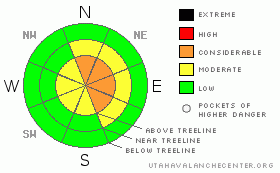
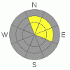
BOTTOM LINE
Danger by aspect and elevation on slopes approaching 35° or steeper.
(click HERE for tomorrow's danger rating)
|
Danger Rose Tutorial
|
At and above treeline the avalanche danger is CONSIDERABLE today and human triggered avalanches are probable on wind drifted slopes steeper than about 35 degrees, especially those facing east, north, northeast and southeast.
In steep, rocky, upper elevation terrain there's a MODERATE or isolated danger of triggering a deeper avalanche which breaks into weaker snow near the ground.
In wind sheltered terrain the avalanche danger is generally LOW. |
|
|
CURRENT CONDITIONS |

|
High pressure over the region allowed skies to clear late yesterday. A slight inversion developed overnight and temperatures are right around 10 degrees at both the trailheads and along the ridges. After a blustery day Monday, winds calmed down around 3:00 this morning. Currently they’re out of the west-southwest, averaging 20 mph with gusts in the mid 30’s. A foot of new snow Monday night helped freshen up the snow surface, but nuking winds damaged a lot of upper elevation terrain. Don’t be too discouraged though, you can still find soft settled powder on wind sheltered, mid elevation, shady slopes. |
|
|
RECENT ACTIVITY |

|
A snowmobiler triggered a deep hard slab avalanche near Humpy Peak on Saturday and it was reported to us late Sunday. The avalanche was 5'-6' deep, occurring in a northeasterly facing chute, approximately 37 degrees in steepness at about 10,500’ in elevation and ran for 600’ vertically. It appears the avalanche was triggered in very shallow portion of the snowpack on a steep rocky breakover, then stepped up, breaking into buried near surface facets in the mid-pack. One rider was caught and buried for a short time, but his helmet was partially sticking out of the snow and he was quickly rescued. Fortunately, everyone in the group was equipped with avalanche rescue gear and the story has a happy outcome.
Click here for a list of recent avalanche activity in the Uinta's.
For more photos of recent avalanche activity click here |
|
|
THREAT #1 |

|
| WHERE |
PROBABILITY |
SIZE |
TREND |

|
|
|
|
| |
|
|
Over the next
24
hours.
|
|
|
Winds have been all over the place the past few days. First, gusting to 70 mph out of the southwest on Sunday, then switching to the northwest on Monday and blowing to 45 mph and finally mellowing out and turning southwest again early this morning. With an abundance of light snow available for transport, wind slabs are fairly widespread and these will remain sensitive to the weight of a rider today. Most of the drifting occurred at the upper elevations, in the wind zone, particularly in terrain with an easterly component to its aspect. Due to the strength of the wind, slabs have formed a little lower down slope than usual, so be suspicious when approaching steep, mid slope breakovers. Remember- the Uinta’s are a huge range and local terrain features can channel wind into odd locations. While the majority of today’s slabs are manageable in size, you’ll need to reevaluate your slope choices on an individual basis, especially if you’re changing drainages, slope aspect or elevation. |
|
|
THREAT #2 |

|
| WHERE |
PROBABILITY |
SIZE |
TREND |
|
|
|
|
| |
|
|
Over the next
24
hours.
|
|
|
I thought we were done talking about deep instabilities, but Saturday’s close call deserves mention and apparently there’s terrain out there where you can still trigger a rogue avalanche which breaks into weak snow near the ground. I’d have to say this is more the exception than the rule. However, with a supportable, strong feeling, go anywhere kind of base; riders are nosing into some steep slopes for the first time this year. If you’re travels take you into steep, radical terrain, particularly slopes that are connected to weak shallow snow, there’s an isolated possibility you can trigger a slide that breaks into weaker snow near the ground. You’ll have to be the judge on this one and carefully evaluate both the snowpack and the consequences of your terrain choices. |
|
|
MOUNTAIN WEATHER |

|
Today we can expect mostly sunny skies with a few high clouds at times. West and southwest winds will blow in the 20’s and 30’s along the high ridges. High temperatures at 8,000’ should reach into the low 30’s and at 10,000’ in the mid to upper 20’s. Overnight lows dive into the mid teens. Quiet weather is on tap for the remainder of the week with a cold storm scheduled to arrive sometime Sunday. |
|
|
GENERAL ANNOUNCEMENTS |
Remember- your observations help to save other riders lives. So if you see or trigger any avalanches please let me know what your seeing. You can reach me at 801-231-2170 or craig@utahavalanchecenter.org
Also, Beacon Basin is up and running and located inside the orange fencing on the northeast corner of the Nobletts Trailhead. In addition, Ted installed a Beacon Park in his neck of the woods, near the Bear River trailhead on the Evanston side of the range, so here's no excuse not to be practicing with your rescue gear.
The information in this advisory expires 24 hours after the date and time posted. I'll update this advisory by 7:00 am on Saturday Mar. 14, 2009. |
|
|
This information does not apply to developed ski areas or highways where avalanche control is normally done. This advisory is from the U.S.D.A. Forest Service, which is solely responsible for its content. This advisory describes general avalanche conditions and local variations always occur. |
|
This advisory provided by the USDA Forest Service, in partnership with:
The Friends of the Utah Avalanche Center, Utah Division of State Parks and Recreation, Utah Division of Emergency Management, Salt Lake County, Salt Lake Unified Fire Authority and the friends of the La Sal Avalanche Center. See our Sponsors Page for a complete list. |
