SPECIAL ANNOUNCEMENT |
 |
In partnership with Park City Powder Cats, we'll be hosting a "hands on" avalanche workshop on Friday, March 6th and Saturday March 7th. Click here for more details.
|
|
|
BOTTOM LINE
Danger by aspect and elevation on slopes approaching 35° or steeper.
(click HERE for tomorrow's danger rating)
|
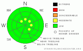
Danger Rose Tutorial
|
In the wind zone, at and above treeline, there are pockets of MODERATE avalanche danger on slopes steeper than about 35 degrees with recent deposits of wind drifted snow. Human triggered avalanches are possible, especially in steep windloaded terrain facing north, northeast, east and southeast.
In wind sheltered terrain the avalanche danger is generally LOW. |
|
|
CURRENT CONDITIONS |

|
The ridge that brought us such a stellar day Saturday has shifted east, allowing clouds to filter into the region. Under mostly cloudy skies this morning, temperatures are a balmy 28 degrees at 10,000’, it’s 33 degrees at 8,000’. Southerly winds increased around 11:00 last night, averaging 20 mph with gusts near 30 mph along the high ridges. Snow surface conditions vary with aspect and elevation, with an abundance of hard, molar rattling old tracks thrown in to keep you on your toes. Ted, Justin and I found good soft powder in upper elevation shady terrain, on our way to installing a new addition to our weather station network. The new site, above Lofty Lake near the Mirror Lake Highway, will be available online early next week. Thanks to Ted, Justin, Howie and Al, along with our good partners at the National Weather Service for all the help making this happen! (Phase one, two, three)
In the mean time you can click here for wind and here for snow data from Upper Weber Canyon. |
|
|
RECENT ACTIVITY |

|
No new avalanche activity reported or observed yesterday.
Click here for a list of recent avalanche activity in the Uinta's.
For more photos of recent avalanche activity click here |
|
|
THREAT #1 |

|
| WHERE |
PROBABILITY |
SIZE |
TREND |
|
|
|
|
| |
|
|
Over the next
24
hours.
|
|
|
Strong winds on Thursday and Friday blew a lot of snow around, forming wind drifts along the leeward side of upper elevation ridges. Yesterday we stomped on steep, wind loaded test slopes and couldn’t get anything to budge. As a matter of fact, the slabs seem tired, lifeless and out of gas… that’s about how I feel this time of year. None the less, there’s probably an old wind slab or two that’s still lurking out there, but these will be limited to steep terrain at and above treeline with an easterly component to the slope’s aspect. Avalanches triggered today will be shallow, but if you’re getting into steep radical terrain they may be big enough to trip you up and roll you into a group of trees or over a cliff. |
|
|
MOUNTAIN WEATHER |

|
A warm, moist southerly flow will bring with it clouds, wind and a little bit of the R word on Monday. Today, southerly winds will average 20 mph with gusts in the 40’s along the high ridges. Even under a blanket of thick clouds, high temperatures will soar into the mid 40’s at 8,000’ and near 40 degrees at 10,000’. Overnight lows will be right around freezing. Moisture works its way into the region Monday with snow levels near 10,000’. Gradual cooling is on tap for Tuesday with the possibility of a stronger system for late Wednesday. |
|
|
GENERAL ANNOUNCEMENTS |
Remember- your observations help to save other riders lives. So if you see or trigger any avalanches please let me know what your seeing. You can reach me at 801-231-2170 or craig@utahavalanchecenter.org
Also, Beacon Basin is up and running and located inside the orange fencing on the northeast corner of the Nobletts Trailhead. In addition, Ted installed a Beacon Park in his neck of the woods, near the Bear River trailhead on the Evanston side of the range, so here's no excuse not to be practicing with your rescue gear.
The information in this advisory expires 24 hours after the date and time posted. I'll update this advisory by 7:00 am on Wednesday Mar. 4, 2009. |
|
|
This information does not apply to developed ski areas or highways where avalanche control is normally done. This advisory is from the U.S.D.A. Forest Service, which is solely responsible for its content. This advisory describes general avalanche conditions and local variations always occur. |
|
This advisory provided by the USDA Forest Service, in partnership with:
The Friends of the Utah Avalanche Center, Utah Division of State Parks and Recreation, Utah Division of Emergency Management, Salt Lake County, Salt Lake Unified Fire Authority and the friends of the La Sal Avalanche Center. See our Sponsors Page for a complete list. |
