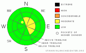
BOTTOM LINE
Danger by aspect and elevation on slopes approaching 35° or steeper.
(click HERE for tomorrow's danger rating)
|
Danger Rose Tutorial
|
In the wind zone, at and above treeline, the avalanche danger is MODERATE on slopes steeper than about 35 degrees with recent deposits of wind drifted snow. Human triggered avalanches are possible, especially in steep windloaded terrain facing north, northeast, east and southeast.
In wind sheltered terrain the avalanche danger is generally LOW. |
|
|
CURRENT CONDITIONS |

|
High pressure is building rapidly and once we get out of the deep freeze this morning, temperatures should rebound nicely. Currently it’s in the low to mid single digits at both 8,000’ and 10,000’. Winds switched to the west and southwest around 3:00 this morning. Not living up to its reputation, Windy Peak is averaging wind speeds in the 10-20 mph range. The northern half of the region picked up 4”-6” of light density, cold smoke the past few days, but strong winds in the high terrain raked the ridges and upper elevation bowls. Your best bet for soft settled powder will be in mid elevation wind protected terrain. |
|
|
RECENT ACTIVITY |

|
No new avalanche activity reported or observed yesterday.
Click here for a list of recent avalanche activity in the Uinta's.
For more photos of recent avalanche activity click here |
|
|
THREAT #1 |

|
| WHERE |
PROBABILITY |
SIZE |
TREND |
|
|
|
|
| |
|
|
Over the next
24
hours.
|
|
|
Wind slabs, near and along the upper ridges is today’s main avalanche concern. Since Thursday morning, winds have been busy at work, whipping the new light density snow into stiff, yet shallowly manageable slabs. The slabs are manageable because they break at your feet or machine or just below you. Recent winds have had a strong westerly component, so as you might expect, wind slabs have formed on slopes with easterly aspects. Due to the strength of the winds, I’d expect drifts formed a little lower downslope than usual and on the leeward side of chutes, gullies and around sub-ridges. Remember- the western Uinta Mountains are a huge range and there are lots of nooks and crannies where wind gets channeled around terrain features, creating usual avalanche conditions. You can get a good handle on the snows stability by digging into it with your hands or shovel. Also, before center-punching a steep line, tweak small test slopes and road cuts similar to what you want to ride on and see how the snow is reacting. Once you’re out of the upper elevation wind zone this all becomes a moot point. |
|
|
MOUNTAIN WEATHER |

|
High pressure brings a strong warming trend to the area today and it will be a spectacular day in the mountains. Winds should remain light, blowing less than 25 mph even along the high peaks. Temperatures will feel spring-like with highs at 8,000’ near 40 degrees and at 10,000’ in the low to mid 30’s. Overnight lows dip into the low 20’s. The high shifts east Sunday and a mild southwest flow develops, allowing moisture to gradually increase over the area Sunday and Monday. Snow showers are on tap for the early portion of the week and a better shot of snow should materialize late Wednesday. |
|
|
GENERAL ANNOUNCEMENTS |
Remember- your observations help to save other riders lives. So if you see or trigger any avalanches please let me know what your seeing. You can reach me at 801-231-2170 or craig@utahavalanchecenter.org
Also, Beacon Basin is up and running and located inside the orange fencing on the northeast corner of the Nobletts Trailhead. In addition, Ted installed a Beacon Park in his neck of the woods, near the Bear River trailhead on the Evanston side of the range, so here's no excuse not to be practicing with your rescue gear.
The information in this advisory expires 24 hours after the date and time posted. I'll update this advisory by 7:00 am on Sunday Mar. 1, 2009. |
|
|
This information does not apply to developed ski areas or highways where avalanche control is normally done. This advisory is from the U.S.D.A. Forest Service, which is solely responsible for its content. This advisory describes general avalanche conditions and local variations always occur. |
|
This advisory provided by the USDA Forest Service, in partnership with:
The Friends of the Utah Avalanche Center, Utah Division of State Parks and Recreation, Utah Division of Emergency Management, Salt Lake County, Salt Lake Unified Fire Authority and the friends of the La Sal Avalanche Center. See our Sponsors Page for a complete list. |
