BOTTOM LINE
Danger by aspect and elevation on slopes approaching 35° or steeper.
(click HERE for tomorrow's danger rating)
|
Danger Rose Tutorial
|
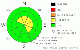
In the wind zone, at and above treeline, the avalanche danger is MODERATE on slopes steeper than about 35 degrees, especially those with recent deposits of wind drifted snow. Human triggered avalanches are possible in steep windloaded terrain facing north, northeast, east and southeast.
In wind sheltered terrain the avalanche danger is generally LOW.
|
|
|
CURRENT CONDITIONS |

|
A fast moving storm system is ushering in clouds and wind, but little in the way of moisture. Speaking of winds, they’ve been at it for days now, generally blowing out of the west and southwest. This morning they’re averaging 15-25 mph along most ridges, gusting into the 40’s along the high peaks. Temperatures are in the mid 20’s at 10,000’ and upper 20’s to low 30’s at 8,000’. The riding and turning conditions are a mixed bag and we could really use a shot of new snow. However, in between the old tracks, suncrusts and windjacked snow, you can still find a few patches of soft creamy powder in sheltered shady terrain.
|
|
|
RECENT ACTIVITY |

|
No new avalanche activity reported or observed yesterday.
Click here for a list of recent avalanche activity in the Uinta's.
For more photos of recent avalanche activity click here |
|
|
THREAT #1 |

|
| WHERE |
PROBABILITY |
SIZE |
TREND |

|
|
|
|
| |
|
|
Over the next
24
hours.
|
|
|
Spring is in the air and our recent bout of warm temperatures combined with strong sunshine has glued the snow in place. Even though the winds have been busy at work, blowing strong since about Thursday, there’s very little snow left to blow around and create dangerous slabs. As a matter of fact, the only slabs we found the past few days are shallow, manageable and easy to detect, forming near or just below ridgelines at the upper elevations. While it may seem pretty mellow out there right now, there are lots of nooks and crannies in the Uinta’s where wind gets channeled around terrain features creating usual avalanche conditions. If you’re getting off the beaten path, take a minute or two and evaluate the snowpack by tweaking small test slopes similar to what you want to ride. Get some solid information about the snowpack before center punching a big bowl or chute.
|
|
|
MOUNTAIN WEATHER |

|
Today should be cloudy, warm and windy with a quick shot of snow developing by late afternoon. Don’t get your hopes up too much; storm totals will only add up to a couple of inches. Winds increase slightly as the day wares on, switching to the west-northwest, averaging 20 mph. with gusts in the 50’s along the high ridges. 8,000’ highs reach into the upper 30’s and at 10,000’ we should see high temperatures near freezing. Overnight lows dive into the low 20’s as a fast moving cold front brushes by the region. Thursday looks like an in-between day, with a stronger looking system on tap for late Thursday into Friday morning. Storm totals should be in the 6” range before a drying trend takes hold for the weekend.
|
|
|
GENERAL ANNOUNCEMENTS |
Remember- your observations help to save other riders lives. So if you see or trigger any avalanches please let me know what your seeing. You can reach me at 801-231-2170 or craig@utahavalanchecenter.org
Also, Beacon Basin is up and running and located inside the orange fencing on the northeast corner of the Nobletts Trailhead. In addition, Ted installed a Beacon Park in his neck of the woods, near the Bear River trailhead on the Evanston side of the range, so here's no excuse not to be practicing with your rescue gear.
The information in this advisory expires 24 hours after the date and time posted. I'll update this advisory by 7:00 am on Saturday Feb. 28, 2009. |
|
|
This information does not apply to developed ski areas or highways where avalanche control is normally done. This advisory is from the U.S.D.A. Forest Service, which is solely responsible for its content. This advisory describes general avalanche conditions and local variations always occur. |
|
This advisory provided by the USDA Forest Service, in partnership with:
The Friends of the Utah Avalanche Center, Utah Division of State Parks and Recreation, Utah Division of Emergency Management, Salt Lake County, Salt Lake Unified Fire Authority and the friends of the La Sal Avalanche Center. See our Sponsors Page for a complete list. |
