SPECIAL ANNOUNCEMENT |
 |
The Windy Peak wind site is back up and running. Click here for current info. I want to thank Ted Scroggin for being a willing participant with Friday’s humbling maintenance outing. It was a classic suffer-fest complete with 50 mph winds, creating sub-zero temperatures, making the work with tiny screw drivers and skin sticking metal objects all that much more enlightening.
Also, Beacon Basin is up and running and located inside the orange fencing on the northeast corner of the Nobletts Trailhead. In addition, Ted installed a Beacon Park in his neck of the woods, near the Bear River trailhead on the Evanston side of the range, so here's no excuse not to be practicing with your rescue gear. |
|
|
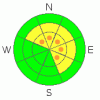
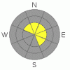
BOTTOM LINE
Danger by aspect and elevation on slopes approaching 35° or steeper.
(click HERE for tomorrow's danger rating)
|
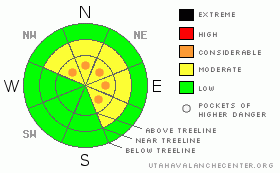
Danger Rose Tutorial
|
At and above treeline there are pockets of CONSIDERABLE avalanche danger today and human triggered avalanches are probable on steep wind loaded slopes, especially those facing northwest through southeast.
Out of the wind the avalanche danger is generally LOW. |
|
|
CURRENT CONDITIONS |

|
A mild southerly flow kept temperatures at bay overnight and currently it’s a balmy 29 degrees at the trailheads and in the mid 20’s at 10,000’. Southwesterly winds picked up around 6:00 last night, blowing steadily in the 20 mph range, gusting in the mid 30’s along the high ridges. Winds have been relentless since Thursday, turning much of our upper elevation terrain into a moonscape. While powder is getting scarce there’s a still patch or two of soft settled snow in wind sheltered shady terrain. |
|
|
RECENT ACTIVITY |

|
No new activity reported yesterday.
On Friday Ted spotted several snowmobile triggered avalanches on steep, wind loaded, north and northeast facing slopes around the Double Hill area (photo one, photo two) and also in Moffit Basin. The slides averaged 2’ deep and were up to 100’ wide. In addition, we noticed two natural cornice releases in upper Weber Canyon which initiated slabs up to 2’ deep on steep, easterly facing slopes.
Click here for a list of recent avalanche activity in the Uinta's.
For more photos of recent avalanche activity click here |
|
|
THREAT #1 |

|
| WHERE |
PROBABILITY |
SIZE |
TREND |
|
|
|
|
| |
|
|
Over the next
24
hours.
|
|
|
Since Thursday, winds have been busy at work forming cornices and wind slabs which are sensitive to the weight of a rider. With yet another round of strong ridgetop winds, I’d expect yet another round of fresh wind slabs formed overnight. They’ll be in the usual suspect terrain- along the leeward side of ridges and terrain features like chutes and gullies. In addition, they will have formed a little lower downslope than you might expect. That’s all pretty straight forward… now here’s the tricky part. Several wind events are starting to stack up on top of each other, forming a thick, dense slab. While these pieces of snow may feel stubborn and glued in, the wild card is if you do trigger a fresh wind slab it could break several feet deep into older drifts, quickly becoming an unmanageable situation. Look for and avoid rounded pillows of snow in steep terrain, especially on slopes with either a north or east component to their aspect. |
|
|
THREAT #2 |

|
| WHERE |
PROBABILITY |
SIZE |
TREND |
|
|
|
|
| |
|
|
Over the next
24
hours.
|
|
|
Cornices have quite grown large and sensitive. In addition to breaking further back than you might expect, they’re also releasing naturally. I’d give these unpredictable pieces of snow a wide berth and think about the consequences of having a bus sized chunk of snow crashing down on you, ruining your day in a hurry. |
|
|
MOUNTAIN WEATHER |

|
High pressure drifts to the east today opening the door to a series of small storms slated to impact the region for most of the upcoming week. Look for thickening clouds, warm temperatures and gusty winds developing today. Southwest winds will be strongest this morning, gusting into the low 50’s along the high ridges, before relaxing in the afternoon and backing off into the 20’s. Snow develops around midnight and overnight low temperatures bottom out in the upper 20’s. Accumulations for the first round of snow should be in the 2”-4” range. A break is slated for Tuesday with another similar system for Wednesday and Thursday. |
|
|
GENERAL ANNOUNCEMENTS |
Remember- your observations help to save other riders lives. So if you see or trigger any avalanches please let me know what your seeing. You can reach me at 801-231-2170 or craig@utahavalanchecenter.org
While it's quiet, now is a great time to schedule a free avalanche awareness class for your group or club. You can reach me at 801-231-2170 or craig@utahavalanchecenter.org for more details.
The information in this advisory expires 24 hours after the date and time posted. I'll update this advisory by 7:00 am on Wednesday Feb. 25, 2009. |
|
|
This information does not apply to developed ski areas or highways where avalanche control is normally done. This advisory is from the U.S.D.A. Forest Service, which is solely responsible for its content. This advisory describes general avalanche conditions and local variations always occur. |
|
This advisory provided by the USDA Forest Service, in partnership with:
The Friends of the Utah Avalanche Center, Utah Division of State Parks and Recreation, Utah Division of Emergency Management, Salt Lake County, Salt Lake Unified Fire Authority and the friends of the La Sal Avalanche Center. See our Sponsors Page for a complete list. |
