SPECIAL ANNOUNCEMENT |
 |
The Windy Peak wind site is back up and running. Click here for current info. I want to thank Ted Scroggin for being a willing participant with yesterday’s brutal maintenance outing. It was a classic suffer-fest complete with 50 mph winds, creating sub-zero temperatures, making the work with tiny screw drivers and skin sticking metal objects all that much more enlightening.
Also, Beacon Basin is up and running and located inside the orange fencing on the northeast corner of the Nobletts Trailhead. In addition, Ted installed a Beacon Park in his neck of the woods, near the Bear River trailhead on the Evanston side of the range, so here's no excuse not to be practicing with your rescue gear. |
|
|
BOTTOM LINE
Danger by aspect and elevation on slopes approaching 35° or steeper.
(click HERE for tomorrow's danger rating)
|

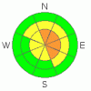
Danger Rose Tutorial
|
The avalanche danger is CONSIDERABLE today and human triggered avalanches are probable in steep wind loaded terrain at and above treeline, especially on slopes facing north, northeast and east.
In addition, the danger of wet avalanches will rise from LOW to MODERATE during the heat of the day on steep low and mid elevation, sun exposed slopes and human avalanches are possible. |
|
|
CURRENT CONDITIONS |

|
High pressure over the region will provide another spectacular day in the mountains as the valley haze begins to build. Currently, temperatures are slightly inverted. At 10,000’ it’s 17 degrees, 8,000’ temperatures are in the mid teens and in terrain where cold air pools, like Lily Lake, it’s 4 degrees. Winds are northerly, blowing 10-20 mph along most mid elevation ridges. It’s a different story up high where winds remain quite active, averaging 20 mph, gusting into the low 30’s. Recent winds hammered above treeline bowls and exposed slopes, but if you lose a little elevation, soft settled powder will be found on sheltered, shady slopes.
|
|
|
RECENT ACTIVITY |

|
Ted spotted several snowmobile triggered avalanches on steep, wind loaded, north and northeast facing slopes yesterday around the Double Hill area (photo one, photo two) and also in Moffit Basin. The slides averaged 2’ deep and were up to 100’ wide. In addition, we noticed two natural cornice releases in upper Weber Canyon which initiated slabs up to 2’ deep on steep, easterly facing slopes.
Click here for a list of recent avalanche in the Uinta's.
For more photos of recent avalanche activity click here |
|
|
THREAT #1 |

|
| WHERE |
PROBABILITY |
SIZE |
TREND |
|
|
|
|
| |
|
|
Over the next
24
hours.
|
|
|
Not only are the western Uinta’s famous for weak, shallow and dangerous snowpack conditions, we’re also known for relentless wind… the past few days haven’t disappointed. West and southwest winds picked up late Thursday blowing 20-30 mph, switching to the west on Friday gusting to 50 mph and finally turned to the north late last night and blew in the 20’s. There’s plenty of light fluffy snow to blow around and recent winds have had no problem forming stiff wind drifts on the leeward side of ridges and little further downslope than usual. While today’s slabs might not be quite as sensitive as yesterday, I’d continue to avoid any fat looking wind drift and these formed mostly on upper elevation slopes facing the north half of the compass, especially those with an easterly component to their aspect. |
|
|
THREAT #2 |

|
| WHERE |
PROBABILITY |
SIZE |
TREND |

|
|
|
|
| |
|
|
Over the next
24
hours.
|
|
|
Cornices have quite grown large and sensitive. In addition to breaking further back than you might expect, they’re also releasing naturally. I’d give these unpredictable pieces of snow a wide berth and think about the consequences of having a bus sized chunk of snow crashing down on you, ruining your day in a hurry. |
|
|
THREAT #3 |

|
| WHERE |
PROBABILITY |
SIZE |
TREND |
|
|
|
|
| |
|
|
Over the next
24
hours.
|
|
|
The sun will be baking sun exposed slopes and the danger of wet avalanches in steep, low and mid elevation terrain will increase during the heat of the day. Remember- the sun is high in the sky and it’s starting to penetrate into steep northerly facing terrain, especially at lower elevations. Think about your exits this afternoon and avoid terrain traps like gullies and steep road cuts where debris can pile up very deeply. |
|
|
MOUNTAIN WEATHER |

|
Look for mostly sunny skies today with high temperatures near 40 degrees at 8,000’ and in the low to mid 30’s at 10,000’. Overnight lows under a veil of high thin clouds dip into the mid 20’s. Winds calm down this morning, switch to the southwest and increase later in the day, gusting into the 30’s along both the mid and high elevation ridges. A moist southwest flow develops by Sunday and a weak but rather moist system crosses the area Monday into Tuesday with another system on Wednesday. Timing and intensity of these storms is rather vague at the moment and there are no well defined cold fronts. I’ll probably have a better handle on all this for tomorrow’s advisory. |
|
|
GENERAL ANNOUNCEMENTS |
Remember- your observations help to save other riders lives. So if you see or trigger any avalanches please let me know what your seeing. You can reach me at 801-231-2170 or craig@utahavalanchecenter.org
While it's quiet, now is a great time to schedule a free avalanche awareness class for your group or club. You can reach me at 801-231-2170 or craig@utahavalanchecenter.org for more details.
The information in this advisory expires 24 hours after the date and time posted. I'll update this advisory by 7:00 am on Sunday Feb. 22, 2009. |
|
|
This information does not apply to developed ski areas or highways where avalanche control is normally done. This advisory is from the U.S.D.A. Forest Service, which is solely responsible for its content. This advisory describes general avalanche conditions and local variations always occur. |
|
This advisory provided by the USDA Forest Service, in partnership with:
The Friends of the Utah Avalanche Center, Utah Division of State Parks and Recreation, Utah Division of Emergency Management, Salt Lake County, Salt Lake Unified Fire Authority and the friends of the La Sal Avalanche Center. See our Sponsors Page for a complete list. |
