SPECIAL ANNOUNCEMENT |
 |
Beacon Basin is up and running and located inside the orange fencing on the northeast corner of the Nobletts Trailhead. In addition, Ted installed a Beacon Park in his neck of the woods, near the Bear River trailhead on the Evanston side of the range, so here's no excuse not to be practicing with your rescue gear. |
|
|
BOTTOM LINE
Danger by aspect and elevation on slopes approaching 35° or steeper.
(click HERE for tomorrow's danger rating)
|
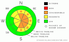
Danger Rose Tutorial
|
The avalanche danger is CONSIDERABLE today and human triggered avalanches are probable in steep wind loaded terrain at and above treeline.
The avalanche danger is generally MODERATE on steep mid elevation slopes and human triggered soft slab avalanches are possible. Be aware that while isolated, it's still possible to trigger avalanches deeper than you might expect, especially where a strengthening slab consisting of several storms worth of snow now overlays buried weak snow.
Wind sheltered terrain generally has a LOW avalanche danger. |
|
|
CURRENT CONDITIONS |

|
Tuesday’s storm was late on arrival to the eastern front, but snow totals started to add up quickly yesterday. The range faired well with a solid foot from Daniel’s to Trail Lake. About 10” fell in the Chalk Creek area and half that amount at the trailheads. West and northwest winds increased around 6:00 last night and have been blowing 15-25 mph along the ridges, gusting in the 30’s and 40’s along the high peaks. Currently, temperatures are in the low to mid teens at 10,000’ and near 20 degrees at 8,000’. |
|
|
RECENT ACTIVITY |

|
Shallow wind drifts and soft slabs reported.
Click here for a list of recent avalanche in the Uinta's.
For more photos of recent avalanche activity click here |
|
|
THREAT #1 |

|
| WHERE |
PROBABILITY |
SIZE |
TREND |

|
|
|
|
| |
|
|
Over the next
24
hours.
|
|
|
Sensitive wind drifts formed at a rapid pace yesterday and these easily broke at your ski tips or around your machine. This type of avalanche is manageable because the slabs predictably break below you, they’re easy to detect and avoid and a well placed slope cut or cornice drop gives you lots of information about the slopes stability. Ted and Grant stomped around in mid elevation terrain in the Gold Hill area yesterday, finding tender soft slabs near or just below ridges. They also found that in continuously steep terrain and big open bowls, even small avalanches built up a good head of steam, packing a punch and depositing debris deep enough to bury a person. With stronger winds overnight, today’s slabs are more widespread and deeper, forming a little lower downslope, as well as around terrain features and on mid-slope break-overs. Remember- avalanche conditions will change with elevation, so get some solid information before center-punching your favorite bowl. Tweak small test slopes and road cuts and see how they react and think about the consequences of the terrain you plan to ride in. |
|
|
THREAT #2 |

|
| WHERE |
PROBABILITY |
SIZE |
TREND |
|
|
|
|
| |
|
|
Over the next
24
hours.
|
|
|
The weak snow created during the early February dry spell hasn’t gone away, as a matter of fact it’s buried and preserved. We’ve been finding this persistent problem child on wind protected slopes where you don’t normally think there’s an avalanche problem. In steep terrain facing the north half of the compass it’s possible to trigger avalanches which break into these weaknesses, creating a deeper and wider avalanche than you might expect; taking out several storms worth of snow. While performing a detailed snowpit test yesterday, Ted and Grant got an interesting surprise as they tried to isolate a column, finding the Thanksgiving raincrust is still a big player in terrain where the snowpack remains thin. (Click here to watch the results) You don’t have to be an avalanche geek or snow scientist to figure out what’s going on here. Take a minute or two, dig into the snow with your hands or shovel and it’s easy to see what kind of snow your riding on. |
|
|
MOUNTAIN WEATHER |

|
The storm is winding down, but we should still see a last gasp of moisture moving through the region which will deposit another couple of inches before it’s all said and done. Northwest winds will be strong the next couple of hours, gusting into the 40’s and 50’s along the highest ridges, before mellowing out later this morning. High temperatures at 8,000’ will be in the mid 20’s and at 10,000’ near 20 degrees. Overnight lows under clearing skies dip into the upper single digits. High pressure with a drying trend takes hold for the latter half of the week into the weekend. The next storm is slated for around Tuesday. |
|
|
GENERAL ANNOUNCEMENTS |
Remember- your observations help to save other riders lives. So if you see or trigger any avalanches please let me know what your seeing. You can reach me at 801-231-2170 or craig@utahavalanchecenter.org
While it's quiet, now is a great time to schedule a free avalanche awareness class for your group or club. You can reach me at 801-231-2170 or craig@utahavalanchecenter.org for more details.
The information in this advisory expires 24 hours after the date and time posted. I'll update this advisory by 7:00 am on Saturday Feb. 21, 2009. |
|
|
This information does not apply to developed ski areas or highways where avalanche control is normally done. This advisory is from the U.S.D.A. Forest Service, which is solely responsible for its content. This advisory describes general avalanche conditions and local variations always occur. |
|
This advisory provided by the USDA Forest Service, in partnership with:
The Friends of the Utah Avalanche Center, Utah Division of State Parks and Recreation, Utah Division of Emergency Management, Salt Lake County, Salt Lake Unified Fire Authority and the friends of the La Sal Avalanche Center. See our Sponsors Page for a complete list. |
