SPECIAL ANNOUNCEMENT |
 |
Beacon Basin is up and running and located inside the orange fencing on the northeast corner of the Nobletts Trailhead. In addition, Ted installed a Beacon Park in his neck of the woods, near the Bear River trailhead on the Evanston side of the range, so here's no excuse not to be practicing with your rescue gear. |
|
|
BOTTOM LINE
Danger by aspect and elevation on slopes approaching 35° or steeper.
(click HERE for tomorrow's danger rating)
|
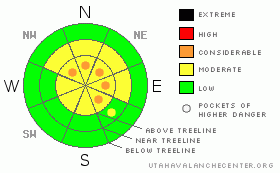
Danger Rose Tutorial
|
Along the high elevation ridges there are pockets of CONSIDERABLE avalanche danger today and human triggered avalanches are probable in steep wind loaded terrain above treeline, especially on slopes facing the north half of the compass.
The avalanche danger is generally MODERATE on steep mid elevation slopes and human triggered avalanches are possible.
Most other slopes generally have a LOW avalanche danger.
The avalanche danger will be rising the next few days.
|
|
|
CURRENT CONDITIONS |

|
In the wake of yesterday’s storm which only deposited an inch or two of new snow, skies cleared out and temperatures dove into the single digits last night. This morning we’re hovering right around zero at 10,000’ and near 7 degrees at 8,000’. West and southwest winds increased slightly yesterday and have been blowing in the teens at most ridgeline locations, gusting in the 20’s and 30’s along the highest ridges. Today’s the day to get after it because all this nice, light, fluffy powder is gonna get be a distant memory in a day or two.
|
|
|
RECENT ACTIVITY |

|
No new avalanche activity to report.
For more photos of recent avalanche activity click here |
|
|
THREAT #1 |

|
| WHERE |
PROBABILITY |
SIZE |
TREND |

|
|
|
|
| |
|
|
Over the next
24
hours.
|
|
|
By all accounts the riding has been epic the past few days and I’m psyched to see people getting into steep terrain when the avalanche conditions are manageable. I think we’ll see one more day where shallow soft slabs along the leeward side of upper elevation ridges are going to be the main avalanche concern.
These soft slabs are manageable because they predictably break at or just below your feet or machine. They're easy to detect and avoid, confined to upper elevation terrain above treeline facing the north half of the compass. Unfortunately, winds are expected to increase throughout the day and there’s plenty of very light snow available for transport. I’d expect slabs will become more widespread, deeper and a bit more sensitive as the day wares on. This morning’s manageable wind drifts could get a little out of hand and pack a punch by days end.
|
|
|
THREAT #2 |

|
| WHERE |
PROBABILITY |
SIZE |
TREND |

|
|
|
|
| |
|
|
Over the next
24
hours.
|
|
|
Our snowpack has been well behaved lately, but don’t let its quiet demeanor lull you into a false sense of confidence… it’s got some issues. First off, the early February dry spell created weak, sugary facets and surface hoar which are now buried and preserved under last weeks storm snow. We might’ve forgotten about them, but the snowpack hasn’t. Next, we’ve been finding yet another rain crust created on January 23rd which is widespread throughout the range, on all aspects up to 10,000’. While not as stout as our Thanksgiving raincrust, the downside is a thin layer of faceted snow forming above it.
Our avalanche conditions have been relatively benign because we’re missing the key ingredient- a slab. Today’s warmer temperatures, especially at mid and lower elevations, could make all the new snow a little more cohesive, essentially forming a slab and adding a little more stress to the buried weak layers. Now that some of the key players are coming into place, it wouldn’t be out of the question for a rider to trigger something a little deeper in the snowpack than you might expect. If the surface snow you’re riding feels like it’s getting denser and a little heavier, avoid steep open bowls and mid slope break-overs and think about the consequences of your terrain choices. |
|
|
MOUNTAIN WEATHER |

|
High pressure dominates our weather pattern today and tonight, giving us mostly sunny skies and warming temperatures. Highs at 8,000’ will be in the mid to upper 20’s and at 10,000’ near 20 degrees. Overnight lows dip into the low teens. Southwest winds get going late in the day, gusting into the 40’s and 50’s along the high ridges. A strengthening low pressure along the west coast today results in increasing southerly winds and warmer temperatures through Monday evening. Expect a warm and windy Monday with thickening clouds. A cold front crosses the region late Monday night and a good shot of snow is slated for Tuesday. I think a foot is a good bet. A ridge returns for midweek leading to a drying trend for the area.
|
|
|
GENERAL ANNOUNCEMENTS |
Remember- your observations help to save other riders lives. So if you see or trigger any avalanches please let me know what your seeing. You can reach me at 801-231-2170 or craig@utahavalanchecenter.org
While it's quiet, now is a great time to schedule a free avalanche awareness class for your group or club. You can reach me at 801-231-2170 or craig@utahavalanchecenter.org for more details.
The information in this advisory expires 24 hours after the date and time posted. I'll update this advisory with a holiday forecast by 7:00 am on Monday Feb. 16, 2009. |
|
|
This information does not apply to developed ski areas or highways where avalanche control is normally done. This advisory is from the U.S.D.A. Forest Service, which is solely responsible for its content. This advisory describes general avalanche conditions and local variations always occur. |
|
This advisory provided by the USDA Forest Service, in partnership with:
The Friends of the Utah Avalanche Center, Utah Division of State Parks and Recreation, Utah Division of Emergency Management, Salt Lake County, Salt Lake Unified Fire Authority and the friends of the La Sal Avalanche Center. See our Sponsors Page for a complete list. |
