SPECIAL ANNOUNCEMENT |
 |
You can get real-time wind and temperature data for Windy Peak by clicking here.
Beacon Basin is up and running and located inside the orange fencing on the northeast corner of the Nobletts Trailhead. In addition, Ted installed a Beacon Park in his neck of the woods, near the Bear River trailhead on the Evanston side of the range, so here's no excuse not to be practicing with your rescue gear. |
|
|
BOTTOM LINE
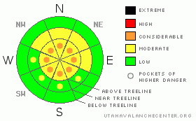
Danger by aspect and elevation on slopes approaching 35° or steeper.
(click HERE for tomorrow's danger rating)
|
Danger Rose Tutorial
|
Along the high elevation ridges there are pockets of CONSIDERABLE avalanche danger today and human triggered avalanches are probable in steep wind loaded terrain above treeline.
The avalanche danger is MODERATE on steep mid elevation slopes with recently formed wind drifts and human triggered avalanches are possible.
Most other slopes generally have a LOW avalanche danger. |
|
|
CURRENT CONDITIONS |

|
Skies are mostly cloudy this morning, temperatures cold, in the low teens and southeasterly winds are blowing 15-25 mph along the upper elevation ridges. An inch of light density, chin tickling snow fell overnight and the riding and turning conditions are about the best they’ve been in years.
|
|
|
RECENT ACTIVITY |

|
No new avalanche activity to report.
For more photos of recent avalanche activity click here |
|
|
THREAT #1 |

|
| WHERE |
PROBABILITY |
SIZE |
TREND |

|
|
|
|
| |
|
|
Over the next
24
hours.
|
|
|
Winds picked up early yesterday afternoon and have been blowing steadily along the upper elevation ridges, forming shallow soft slabs that are sensitive to the weight of a person. These manageable drifts are easy to detect and avoid, confined to upper elevation leeward terrain above treeline.
|
|
|
THREAT #2 |

|
| WHERE |
PROBABILITY |
SIZE |
TREND |

|
|
|
|
| |
|
|
Over the next
24
hours.
|
|
|
After a shaky start to the season, the snowpack has grown thick and relatively strong and many of our worries near the ground are well behaved at the moment. However, with a vigorous looking storm slated for early next week things could change in a hurry. The past few days we’ve been looking for potential problems and just like a detective trying to solve a crime, we’ve come up with a few shady characters that could give us trouble once a big storm rolls around. The most obvious and certainly most notorious of them is a weak layer of sugary snow formed during the early February dry spell. We’ve been finding both near surface facets and surface hoar which are now buried and preserved under last weeks storm snow. We might’ve forgotten them, but the snowpack has an amazing memory.
Another interesting layer is a rain crust created on January 23rd which seems to be widespread throughout the range, on all aspects up to 10,000’. While not as stout as our Thanksgiving raincrust, the downside is a thin layer of faceted snow is forming above it, setting the stage for a dangerous avalanche cycle should all the components come together. With either scenario the key player missing right now is a cohesive slab.
|
|
|
MOUNTAIN WEATHER |

|
We should see a good shot of snow this morning as a storm tracks through the region from the south. Snow will start by around sunrise, continuing into early afternoon, stacking up 3”-6” before exiting the state by early evening. Winds will be out of the west and southwest, gusting in the low 30’s, before switching to the northwest this afternoon. High temperatures at 8,000’ will be in the low 20’s and it’ll be in the mid to upper teens at 10,000’. Overnight lows should bottom out near zero. A ridge sets up tonight through Sunday night providing clear skies. The next storm system affects the region late Monday through Tuesday, with a strong frontal passage anticipated for early Tuesday morning.
|
|
|
GENERAL ANNOUNCEMENTS |
Remember- your observations help to save other riders lives. So if you see or trigger any avalanches please let me know what your seeing. You can reach me at 801-231-2170 or craig@utahavalanchecenter.org
While it's quiet, now is a great time to schedule a free avalanche awareness class for your group or club. You can reach me at 801-231-2170 or craig@utahavalanchecenter.org for more details.
The information in this advisory expires 24 hours after the date and time posted. I'll update this advisory by 7:00 am on Sunday Feb. 15, 2009. |
|
|
This information does not apply to developed ski areas or highways where avalanche control is normally done. This advisory is from the U.S.D.A. Forest Service, which is solely responsible for its content. This advisory describes general avalanche conditions and local variations always occur. |
|
This advisory provided by the USDA Forest Service, in partnership with:
The Friends of the Utah Avalanche Center, Utah Division of State Parks and Recreation, Utah Division of Emergency Management, Salt Lake County, Salt Lake Unified Fire Authority and the friends of the La Sal Avalanche Center. See our Sponsors Page for a complete list. |
