SPECIAL ANNOUNCEMENT |
 |
You can get real-time wind and temperature data for Windy Peak by clicking here.
Beacon Basin
is up and running and located inside the orange fencing on the northeast corner of the Nobletts Trailhead.
|
|
|
BOTTOM LINE
Danger by aspect and elevation on slopes approaching 35° or steeper.
(click HERE for tomorrow's danger rating)
|
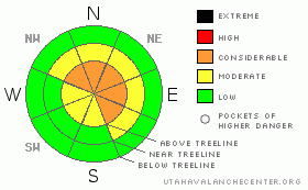
Danger Rose Tutorial
|
There is a CONSIDERABLE avalanche danger today on steep, upper elevation slopes with recent deposits of wind drifted snow. Human triggered avalanches are probable especially in terrain above treeline on slopes facing east, north, northeast and southeast.
A MODERATE danger for avalanches within the new storm snow exists on steep mid and upper elevation wind sheltered terrain and human triggered slides are still possible.
Most other slopes generally have a LOW avalanche danger. |
|
|
CURRENT CONDITIONS |

|
An active weather pattern over the region dumped a surprising amount of snow Monday, stacking up over a foot along most of our upper elevation terrain. Lingering snow showers yesterday didn’t add up to much, just an inch or two fell, but don’t get too discouraged, we’re in between storms and there’s more on the way. Southwest winds increased along the high ridges around noon yesterday and have been averaging 20 mph with gusts in the mid 20’s. Currently, temperatures are near 8 degrees at 10,000’ and in the mid teens at 8,000’. The riding and turning conditions are nearing epic proportions.
|
|
|
RECENT ACTIVITY |

|
No new avalanche activity to report.
For more photos of recent avalanche activity click here |
|
|
THREAT #1 |

|
| WHERE |
PROBABILITY |
SIZE |
TREND |

|
|
|
|
| |
|
|
Over the next
24
hours.
|
|
|
Fresh wind slabs along the leeward side of upper elevation ridges were sensitive yesterday and with continued winds overnight and this morning, they’ve grown a little deeper and are more widespread. Today you’ll want to continue to look for and avoid recently wind loaded slopes, especially those facing north, northeast, east and southeast which are at and above treeline. Once you loose a little elevation and get off the ridges, wind drifting becomes a non-issue.
|
|
|
THREAT #2 |

|
| WHERE |
PROBABILITY |
SIZE |
TREND |

|
|
|
|
| |
|
|
Over the next
24
hours.
|
|
|
The new light fluffy snow was predictably reactive to the weight of a person yesterday and in wind sheltered terrain, sluffs were easy to initiate on steep slopes- in general a very manageable avalanche condition. While many of these new snow instabilities usually settle out quickly, I think they may be with us a little longer because of the old weak snow surface Monday’s storm helped to bury and preserve. Yesterday we found sugary, near surface facets along with a thin layer of surface hoar buried underneath the new storm snow. Most of these fragile layers were destroyed near the ridges, however they’re still very prevalent in wind sheltered terrain. This could be a big player in our next avalanche cycle. We might forget about it, but the snowpack has an amazing memory. With more storms on the way we’ll have to keep on eye on this notoriously tricky layer.
|
|
|
MOUNTAIN WEATHER |

|
A break in the action this morning and then it looks like a weak storm system brushes the area late today, bringing another light round of snow to the region. Unfortunately, much of the energy remains in the southern and central mountains, though we'll pick up a couple of inches late today into tonight. West and southwest winds will average in the teens, gusting into the low 30’s along the high ridges, before mellowing out later today. High temperatures at 8,000’ will be in the low to mid 20’s and at 10,000’ in the upper teens. Overnight lows return to the low single digits. A more potent system impacts the state tomorrow, but again most of the energy dives to the south. There’s perhaps a better shot of snow headed our way for Friday with more weather for the weekend.
|
|
|
GENERAL ANNOUNCEMENTS |
Remember- your observations help to save other riders lives. So if you see or trigger any avalanches please let me know what your seeing. You can reach me at 801-231-2170 or craig@utahavalanchecenter.org
While it's quiet, now is a great time to schedule a free avalanche awareness class for your group or club. You can reach me at 801-231-2170 or craig@utahavalanchecenter.org for more details.
The information in this advisory expires 24 hours after the date and time posted. I'll update this advisory by 7:00 am on Saturday Feb. 14, 2009. |
|
|
This information does not apply to developed ski areas or highways where avalanche control is normally done. This advisory is from the U.S.D.A. Forest Service, which is solely responsible for its content. This advisory describes general avalanche conditions and local variations always occur. |
|
This advisory provided by the USDA Forest Service, in partnership with:
The Friends of the Utah Avalanche Center, Utah Division of State Parks and Recreation, Utah Division of Emergency Management, Salt Lake County, Salt Lake Unified Fire Authority and the friends of the La Sal Avalanche Center. See our Sponsors Page for a complete list. |
