SPECIAL ANNOUNCEMENT |
 |
Our third annual Avalanche Center fundraising ride is Saturday February 7th. Click here for more details. |
|
|
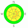
BOTTOM LINE
Danger by aspect and elevation on slopes approaching 35° or steeper.
(click HERE for tomorrow's danger rating)
|

Danger Rose Tutorial
|
At and above treeline there are pockets of CONSIDERABLE avalanche danger and human triggered avalanches are still probable on steep wind loaded slopes with an easterly component to their aspect.
In addition, while deep dangerous avalanches which break into old snow near the ground are becoming more isolated events, a person could still trigger scary slides in steep, rocky, upper elevation terrain which has a shallow, weak snowpack. A MODERATE avalanche danger exists in this type of terrain.
Most other slopes generally have a LOW avalanche danger. |
|
|
CURRENT CONDITIONS |

|
Skies are clear this morning, west-southwest winds blowing 10-20 mph along the ridges and temperatures are near 16 degrees at both 8,000’ and 10,000’. The mid week wind event raked the upper elevations and much of our above treeline terrain looks like the moon. In addition, it’s that time of year when the sun is getting high in the sky, creating tricky crusts on sunny slopes. But in between the windjacked snow and sun crusts, good cold settled powder will be found, especially in shady wind sheltered terrain. |
|
|
RECENT ACTIVITY |

|
A few natural pockets from Wednesday's wind event.
For more photos of recent avalanche activity click here |
|
|
THREAT #1 |

|
| WHERE |
PROBABILITY |
SIZE |
TREND |
|
|
|
|
| |
|
|
Over the next
24
hours.
|
|
|
Wednesday’s hurricane force winds created widespread, sensitive wind slabs and the region saw a few natural avalanches on steep wind loaded slopes. While warmer temperatures are helping to weld these slabs in place, there still may be a few rogue slabs out there which a rider could trigger today. You’ll find these at and above treeline on slopes with an easterly component to their aspect. Also be aware- cornices have grown large and may break back a little further than you expect. |
|
|
THREAT #2 |

|
| WHERE |
PROBABILITY |
SIZE |
TREND |
|
|
|
|
| |
|
|
Over the next
24
hours.
|
|
|
Yesterday, Ted and I went out hunting for instabilities and were psyched to find our snowpack behaving more like it should this time of year, especially where the pack has grown deep. Remember though, we don’t trigger dangerous avalanches from areas where the snowpack is deep and stable... nope, we trigger them from shallow spots or deficit zones. So the key here is to still avoid terrain where the snowpack is thin and the usual suspects- steep, rocky slopes- come to mind. While it’s becoming more of an isolated event, there’s still terrain out there where you could trigger a scary avalanche which breaks into weak snow near the ground. You’d most likely find this condition at the mid and upper elevations on slopes facing the north half of the compass. In addition, terrain outside the core of the western Uinta’s remains thin and therefore a little trickier. A re-evaluation of the snowpack would be in order the further east you travel. |
|
|
MOUNTAIN WEATHER |

|
High pressure breaks down today, allowing colder air to filter in the region. Expect increasing clouds this afternoon with a little dusting of snow expected overnight. Today’s high temperatures will be in the mid 30’s at 8,000’, just about freezing at 10,000’. Overnight lows dive into the mid teens. Northwest winds increase slightly this afternoon and evening, gusts in the upper 30’s along the high ridges are likely. Cooler with light snow showers for Sunday morning, before high pressure quickly rebounds through mid week. There are still no big storms in sight. |
|
|
GENERAL ANNOUNCEMENTS |
Remember- your observations help to save other riders lives. So if you see or trigger any avalanches please let me know what your seeing. You can reach me at 801-231-2170 or craig@utahavalanchecenter.org
While it's quiet, now is a great time to schedule a free avalanche awareness class for your group or club. You can reach me at 801-231-2170 or craig@utahavalanchecenter.org for more details.
The information in this advisory expires 24 hours after the date and time posted. I'll update this advisory by 7:00 am on Sunday Feb. 1, 2009. |
|
|
This information does not apply to developed ski areas or highways where avalanche control is normally done. This advisory is from the U.S.D.A. Forest Service, which is solely responsible for its content. This advisory describes general avalanche conditions and local variations always occur. |
|
This advisory provided by the USDA Forest Service, in partnership with:
The Friends of the Utah Avalanche Center, Utah Division of State Parks and Recreation, Utah Division of Emergency Management, Salt Lake County, Salt Lake Unified Fire Authority and the friends of the La Sal Avalanche Center. See our Sponsors Page for a complete list. |
