AVALANCHE WARNING »
Dangerous avalanche conditions are occuring or are imminent.
Backcountry travel in avalanche terrain is not recommended.
|
 |
Notice: An Avalanche Warning has been issued for the western Uinta Mountains. Recent heavy, dense snow and accumulating water weights will severely tax an inherently weak and unstable snowpack. Large, dangerous and possibly deadly human triggered avalanches are likely on steep, mid and upper elevation slopes, especially those facing the north half of the compass.
|
|
|
SPECIAL ANNOUNCEMENT |
 |
Our third annual Avalanche Center fundraising ride is Saturday February 7th. Click here for more details.
|
|
|
BOTTOM LINE
Danger by aspect and elevation on slopes approaching 35° or steeper.
(click HERE for tomorrow's danger rating)
|

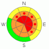
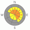
Danger Rose Tutorial
|
At and above treeline the avalanche danger is HIGH today for triggering new snow avalanches and for deep, dangerous avalanches which break into old snow near the ground. Both human triggered and natural avalanches are likely on slopes steeper than 35 degrees. Dangerous avalanche conditions exist on steep slopes facing northwest, north, northeast, east and southeast which are rocky with a shallow, weak underlying snowpack.
Mid elevations have a CONSIDERABLE avalanche danger on slopes steeper than 35 degrees and human triggered avalanches are probable.
At lower elevations the danger of wet avalanches is generally MODERATE and human triggered avalanches are possible. Be aware- some steep, northerly facing low elevation slopes have a CONSIDERABLE avalanche danger and wet, human triggered avalanches are probable in this type of terrain.
|
|
|
CURRENT CONDITIONS |

|
A deep, moist southwest flow over the region is the gift that keeps giving and storm totals are beginning to add up. In the past 24 hours we’ve received another 10” of snow, nearly two feet in 48 hours and we’ve slammed 2” of water on top of our structurally challenged snowpack. At the lower elevations about half that amount has fallen and it’s not the kind of snow our license plates brag about. As a matter of fact, low elevation rain has fallen since Friday morning. Winds have remained fairly manageable, in the 10-25 mph range at most locations for the past 24 hours, though gusts in the 40’s along the high peaks blew from late Saturday afternoon to about midnight. As of 3:00 this morning, there’s hardly a breath of wind and even along the high peaks it’s blowing less than 10 mph.
|
|
|
RECENT ACTIVITY |

|
No new activity to report.
For recent accident reports click here
For more photos of recent avalanche activity click here
|
|
|
THREAT #1 |

|
| WHERE |
PROBABILITY |
SIZE |
TREND |
|
|
|
|
| |
|
|
Over the next
24
hours.
|
|
|
This isn’t the type of storm where winds are raging and it’s an epic, white knuckle adventure just getting to the trailhead. Nope, this is the kind of storm where snow and water totals creep up on us, the weak layers in our snowpack can’t take any more weight and large pieces of snow start peeling out naturally. Remember- each time we’ve loaded the Uinta snowpack this year, whether by heavy new snow or nuking winds, we’ve experienced a deep, dangerous avalanche cycle. It’s been an unusual 48 hours on the eastern front with damp, Gortex soaking white rain and snow falling at the lower elevations and Sierra-esque heavy snows accumulating up high at rates of 2”-3” an hour Saturday. Everyone I talked to commented how it feels like late March or April and we were all wringing the water out of our gear at the trailheads yesterday afternoon… unusual weather makes unusual avalanches. The stability pattern will be tricky and slopes that ran during the Christmas cycle are thin and weak and should be the first slopes to avalanche. These slides will seem tame compared to the terrain that didn’t slide in December. Steep slopes are nothing to monkey around with today. Along with natural avalanches, large, dangerous and possibly deadly human triggered avalanches are likely, especially at and above treeline in steep terrain facing the north half of the compass. In addition, you need to avoid avalanche runout zones and think about steep slopes above you even if you’re playing on low angle terrain.
|
|
|
THREAT #2 |

|
| WHERE |
PROBABILITY |
SIZE |
TREND |
|
|
|
|
| |
|
|
Over the next
24
hours.
|
|
|
The storm snow seems fairly glued in, but any new snow slide triggered could break into weak snow as it descends a slope, initiating a much larger, deeper and scarier avalanche than you bargained for. Your best bet is to avoid steep, upper elevation slopes where storm totals are nearing two feet.
|
|
|
THREAT #3 |

|
| WHERE |
PROBABILITY |
SIZE |
TREND |

|
|
|
|
| |
|
|
Over the next
24
hours.
|
|
|
With warm temperatures still on tap and a damp, water logged snowpack down low, the danger for wet avalanches still exists on steep, low elevation slopes. Think about your exits today and avoid low elevation terrain traps where concrete-like avalanche debris will pile up very deeply.
|
|
|
MOUNTAIN WEATHER |

|
The warm, moist west to southwest flow remains over the region for one more day, before colder air filters into the region. After a morning respite, dense, heavy snow will begin to fall later today with additional accumulations close to a foot at the upper elevations. Winds should remain manageable, blowing 5-15 mph at most ridgetop locations, gusting into the mid 20’s along the high ridges. Slightly cooler temperatures are on tap today with highs at 8,000’ reaching into the mid 30’s and at 10,000’ in the upper 20’s. Overnight lows dive into the single digits as the cold portion of the storm arrives. Snow continues through tonight with additional accumulations in the 6”-10” range. Scattered snow showers are slated for Monday with much colder temperatures. Daytime highs only reach into the low 20’s. Dry weather is expected for midweek.
|
|
|
GENERAL ANNOUNCEMENTS |
Remember- your observations help to save other riders lives. So if you see or trigger any avalanches please let me know what your seeing. You can reach me at 801-231-2170 or craig@utahavalanchecenter.org
While it's quiet, now is a great time to schedule a free avalanche awareness class for your group or club. You can reach me at 801-231-2170 or craig@utahavalanchecenter.org for more details.
The information in this advisory expires 24 hours after the date and time posted. I'll update this advisory by 7:00 am on Wednesday Jan. 28, 2009. |
|
|
This information does not apply to developed ski areas or highways where avalanche control is normally done. This advisory is from the U.S.D.A. Forest Service, which is solely responsible for its content. This advisory describes general avalanche conditions and local variations always occur. |
|
This advisory provided by the USDA Forest Service, in partnership with:
The Friends of the Utah Avalanche Center, Utah Division of State Parks and Recreation, Utah Division of Emergency Management, Salt Lake County, Salt Lake Unified Fire Authority and the friends of the La Sal Avalanche Center. See our Sponsors Page for a complete list. |
