SPECIAL ANNOUNCEMENT |
 |
Our third annual Avalanche Center fundraising ride is Saturday February 7th. Click here for more details.
|
|
|
BOTTOM LINE
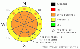
Danger by aspect and elevation on slopes approaching 35° or steeper.
(click HERE for tomorrow's danger rating)
|
Danger Rose Tutorial
|
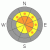
At and above treeline the avalanche is CONSIDERABLE today for triggering new snow avalanches and for deep, dangerous avalanches which break into old snow near the ground. Human triggered avalanches are probable on slopes steeper than 35 degrees. Dangerous avalanche conditions still exist on steep slopes facing northwest, north, northeast, east and southeast which are rocky with a shallow, weak underlying snowpack.
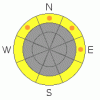
Mid elevations have a MODERATE avalanche danger on slopes steeper than 35 degrees and human triggered avalanches are possible. Be aware- you can still trigger scary avalanches, especially in terrain where the snowpack is less than about 4' deep.
At lower elevations the danger of wet avalanches may rise from MODERATE to CONSIDERABLE especially if we receive any measurable amounts of rain.
|
|
|
CURRENT CONDITIONS |

|
Finally, some new snow totals to talk about. Yesterday’s storm system is just the first in a series of impulses that will affect the region in the next few days. With a moist southwest flow in place, the western Uinta’s faired well and snow totals throughout the range are pretty evenly disbursed. Nearly 10” of new snow with .90" of water stacked up in the high terrain, half that amount at the mid elevations and a mix of wet glop and rain down at the trailheads. West-southwest winds have been relatively well behaved, picking up for a few hours late last night, blowing into the mid 20’s, before backing off into the single digits. It’s calm even along the high peaks, blowing less than 15 mph. Temperatures are in the mid to upper 20’s at 10,000’, near freezing at the trailheads. Yesterday’s rain/snow line was at about 9,200’, so don’t get discouraged with conditions down low. Spongy, Sierra-esque powder riding and turning conditions await and the snow gets lighter and deeper with elevation gain.
|
|
|
RECENT ACTIVITY |

|
No new activity to report.
For recent accident reports click here
For more photos of recent avalanche activity click here
|
|
|
THREAT #1 |

|
| WHERE |
PROBABILITY |
SIZE |
TREND |

|
|
|
|
| |
|
|
Over the next
24
hours.
|
|
|
While the recent spell of clear, warm, dry weather helped to strengthen some of our deeper instabilities; it was a double edged sword, creating a whole new host of weak snow surfaces. Yesterday, we found the new snow very sensitive and it was easy to initiate soft slabs on steep slopes that stacked up a surprisingly deep amount of debris. Today’s most obvious avalanche concern is within the new snow/old snow interface. As storm totals start to stack up, you’ll be able to easily initiate soft slabs that may entrain more snow than you bargained for. Remember to tweak small test slopes with little consequence and get some solid information before getting after the big terrain.
|
|
|
THREAT #2 |

|
| WHERE |
PROBABILITY |
SIZE |
TREND |
|
|
|
|
| |
|
|
Over the next
24
hours.
|
|
|
The snowpack is at a cross roads right now, a mid life crisis of sorts. Yes, it’s starting to gain strength and our snowpit results reveal our problem child near the ground is becoming better behaved over time. However, the basic setup in the snowpack remains structurally unstable. A spring-like pattern is setting up over the region and water totals will start to add up during this storm cycle. That being said, we’ll need to measure the snow not only in inches or feet, but also how much water weight is added. As dense heavy snow piles up, I think this will begin to activate the deeper buried weak layers in the snowpack. Steep, rocky slopes with a thin, shallow snowpack will be likely suspects. Human triggered avalanches that break into deep, buried weak layers will become more widespread throughout the storm cycle. This is definitely not the time to get complacent or lured into a false sense of snow stability. |
|
|
THREAT #3 |

|
| WHERE |
PROBABILITY |
SIZE |
TREND |
|
|
|
|
| |
|
|
Over the next
24
hours.
|
|
|
It’s wet and manky down low and any rain that falls at lower elevations will make the danger of wet avalanche activity rise in a hurry, especially on steep north facing slopes. If you’re encountering rain on your way back to the rig, carefully assess your exits and avoid steep road cuts, gullies and other natural terrain traps where avalanche debris will pile up very deeply. |
|
|
MOUNTAIN WEATHER |

|
A warm, moist, west-southwest flow over the region will continue to develop over the weekend, leading to a good shot of snow through Monday. We should see mostly cloudy skies today with periods of snow. Daytime accumulations should be in the 4”-6” range with similar amounts overnight. Winds will be out of the west-southwest blowing 10-20 mph with gusts in the low 30’s along the highest ridges. High temperatures will be April-like, in the mid to upper 30’s at 8,000’ and near freezing at 10,000’. Overnight lows only dip into the mid 20’s. Another round of snow is expected on Sunday with colder air filtering into the region late Sunday and Monday, giving us our best shot of accumulating snowfall.
|
|
|
GENERAL ANNOUNCEMENTS |
Remember- your observations help to save other riders lives. So if you see or trigger any avalanches please let me know what your seeing. You can reach me at 801-231-2170 or craig@utahavalanchecenter.org
While it's quiet, now is a great time to schedule a free avalanche awareness class for your group or club. You can reach me at 801-231-2170 or craig@utahavalanchecenter.org for more details.
The information in this advisory expires 24 hours after the date and time posted. I'll update this advisory by 7:00 am on Sunday Jan. 25, 2009. |
|
|
This information does not apply to developed ski areas or highways where avalanche control is normally done. This advisory is from the U.S.D.A. Forest Service, which is solely responsible for its content. This advisory describes general avalanche conditions and local variations always occur. |
|
This advisory provided by the USDA Forest Service, in partnership with:
The Friends of the Utah Avalanche Center, Utah Division of State Parks and Recreation, Utah Division of Emergency Management, Salt Lake County, Salt Lake Unified Fire Authority and the friends of the La Sal Avalanche Center. See our Sponsors Page for a complete list. |
