SPECIAL ANNOUNCEMENT |
 |
Our third annual Avalanche Center fundraising ride is Saturday February 7th. Click here for more details.
|
|
|
BOTTOM LINE
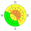
Danger by aspect and elevation on slopes approaching 35° or steeper.
(click HERE for tomorrow's danger rating)
|
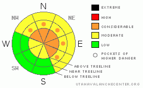
Danger Rose Tutorial
|
At and above treeline the avalanche danger remains CONSIDERABLE today for triggering deep, dangerous avalanches which break into old snow near the ground. Human triggered avalanches are probable on slopes steeper than 35 degrees, especially those facing northwest, north, northeast, east and southeast which are steep and rocky with a shallow, weak underlying snowpack.
Mid elevations have a MODERATE avalanche danger on slopes steeper than 35 degrees facing the north half of the compass and human triggered avalanches are possible. Be aware- you can still trigger scary avalanches, especially in terrain where the snowpack is less than about 4' deep.
In wind sheltered terrain and on most south facing slopes at mid and low elevations the avalanche danger is generally LOW.
|
|
|
CURRENT CONDITIONS |

|
It looks like one last day of high and dry weather, before a weak system slides through the area on Thursday. Under clear skies this morning, temperatures are in the low to mid 30’s at both 8,000’ and 10,000’…. it’s a bone chilling 18 degrees in foggy Salt Lake City. Winds are picking up slightly, blowing 15-25 mph along the high ridges. Riding and turning conditions are getting a little grim, but you can still find soft settled powder in sheltered shady terrain.
|
|
|
RECENT ACTIVITY |

|
No new activity to report.
For recent accident reports click here
For more photos of recent avalanche activity click here
|
|
|
THREAT #1 |

|
| WHERE |
PROBABILITY |
SIZE |
TREND |
|
|
|
|
| |
|
|
Over the next
24
hours.
|
|
|
It’s been nearly a week since our last human triggered avalanche and with the lack of recent slide activity you’d have to think we're finally good to go. However, much like the car salesman trying to get the last Hummer off the lot before gas prices skyrocket, once I take a good look at the details I’m not so convinced. The problem with our snowpack is when we peak under the hood we see persistent buried weaknesses that aren’t gaining much strength. Sure you can ride plenty of slopes and not trigger avalanches, but if you’re getting into terrain that didn’t slide big during the Christmas avalanche cycle, you can still trigger avalanches to the ground. Likely suspect slopes are mid and upper elevation, steep rocky terrain facing the north half of the compass with a thin, weak underlying snowpack. Remember- the Uinta snowpack is different this year and we’ve got to adjust our riding habits accordingly.
|
|
|
THREAT #2 |

|
| WHERE |
PROBABILITY |
SIZE |
TREND |
|
|
|
|
| |
|
|
Over the next
24
hours.
|
|
|
Not much in this department, but as always avoid any fat looking, hollow sounding pillow of snow. These are most prevalent on upper elevation, leeward slopes with an easterly component to their aspect. |
|
|
MOUNTAIN WEATHER |

|
Mostly sunny skies for a good portion of the day and continued warm temperatures are on tap. Highs at 8,000’ will be near 50 degrees and at 10,000’ in the low to mid 40’s. Overnight lows under mostly cloudy skies will be near 20 degrees. Winds increase slightly later today, blowing out of the southwest averaging 15-20 mph with gusts in the upper 30’s along the high ridges. A weak, but moist system slides through the region on Thursday giving us a few inches of snow and cooler temperatures. It looks like a cloudy, unsettled pattern for Friday through the weekend. Unfortunately there are no big storms in sight. |
|
|
GENERAL ANNOUNCEMENTS |
Remember- your observations help to save other riders lives. So if you see or trigger any avalanches please let me know what your seeing. You can reach me at 801-231-2170 or craig@utahavalanchecenter.org
While it's quiet, now is a great time to schedule a free avalanche awareness class for your group or club. You can reach me at 801-231-2170 or craig@utahavalanchecenter.org for more details.
The information in this advisory expires 24 hours after the date and time posted. I'll update this advisory by 7:00 am on Saturday Jan. 24, 2009. |
|
|
This information does not apply to developed ski areas or highways where avalanche control is normally done. This advisory is from the U.S.D.A. Forest Service, which is solely responsible for its content. This advisory describes general avalanche conditions and local variations always occur. |
|
This advisory provided by the USDA Forest Service, in partnership with:
The Friends of the Utah Avalanche Center, Utah Division of State Parks and Recreation, Utah Division of Emergency Management, Salt Lake County, Salt Lake Unified Fire Authority and the friends of the La Sal Avalanche Center. See our Sponsors Page for a complete list. |
